Part II | Thesis Project Proposal
GRADUATE THESIS | WINTER + SPRING 2023
A City for Everyone Promoting Housing Diversity
Committee: Rick Mohler (University of Washington) and Brad Khouri (B9 Architects)
Like many U.S. cities, Seattle’s built environment has been shaped by both public policy and market forces which have created a racially and economically segregated city. Up to 70 percent of land zoned for residential use is set aside for detached single-family structures. This has artificially limited the housing supply which has exacerbated the increasing demand for housing and has driven up the cost of living. Those most affected and facing displacement by these issues include long-term residents, low-income communities, and communities of color. The harms of overly restrictive zoning can be categorized using six main issues: 1) affects affordability, 2) racial and economic inequalities, 3) environmental impacts, 4) economic impacts, 5) limits housing choices and diversity, and 6) contributes to homelessness. Yet, exclusionary zoning laws and practices like minimum lot size requirements, parking minimums, and restrictions on density continue to exist. Thus, restructuring zoning policies is both a racial justice and a climate justice issue. By examining Seattle, this thesis aims to provide an examination of increasing housing density and diversity as a means to increase housing accessibility and affordability. This thesis will examine the current state of Seattle’s housing crisis, dive into Seattle’s land-use history, outline current proposed solutions, review case studies, and explore what densifying Seattle could look like with a series of recommendations for the city of Seattle to consider.
“History has shown that passively waiting for gradual change towards integration is not —and never will be— enough.
De jure segregation can only be rectified through de jure integration, and a great deal remains to be done.”
Kim, Michael.
“Exclusionary Economic Zoning: How The United States Government Circumvented Prohibitions On Racial Zoning Through The Standard State Zoning Enabling Act.” 2021.4 | Designs and Recommendations
Seattle’s Evolution
Possible Changes in NR Zones
In considering the future of Seattle’s Neighborhood Residential (NR) Zones, this project consulted with the Office of Planning and Community Development (OPCD) to understand the metrics that were being used by the city in the 2024 Comprehensive Plan Major Update. Using OPCD’s baseline proposal for three key NR zones: Low, Mid, and High, as well as their preliminary density and FAR metrics, this thesis explores the possible changes in NR zones. As Seattle’s least dense residential areas, the NR zones offer significant potential and opportunities for accommodating additional housing units within their existing urban form. First, as discussed, these neighborhoods have long-standing traditions of racial and economic exclusion. Mending these exclusionary practices is key to creating a more equitable future for housing. By prioritizing density and diversity in these areas, rectifying these inequities and fostering inclusive communities can be pursued. Second, increasing housing density in these areas, which account for 70 percent of residentially zoned land (Seattle Planning Commission, Neighborhoods for All, 2018) can alleviate the strain on high-demand areas outlined by previous Comprehensive Plans as “urban villages.” This can begin to address issues of decreased population in low-density neighborhoods outlined earlier (Bertolet, 2017). Lastly, focusing on Seattle’s least dense neighborhoods aligns with the principles of sustainable urban development by utilizing existing urban neighborhoods that have access to transportation, services, green space, and amenities nearby (Henry, 2023). This will curtail urban sprawl, reduce commuting distances, and foster a more balanced distribution of resources. The focus on the three NR zones facilitates the efficient utilization of existing resources, fosters equity in housing opportunities, and supports sustainable development practices to provide for a more inclusive, resilient, and livable city.
Using OPCD’s baseline proposal for the three NR zones, as well as their preliminary density and FAR metrics, this thesis proposes that with the context of the WA State Middle Housing Bill (HB 1110) and the opportunity that OPCD currently has, it can push further. First, this thesis will examine the opportunities within lot variability within OPCD’s three NR zones, then it will provide examples of housing designs that fit within some of the proposed suggestions, and lastly, it will discuss additional considerations that may be relevant in some neighborhoods. The goal is to strike a careful balance between these elements while achieving a transformative impact on Seattle’s housing landscape that fosters increased housing choices.
Possibilities in Lot Variability
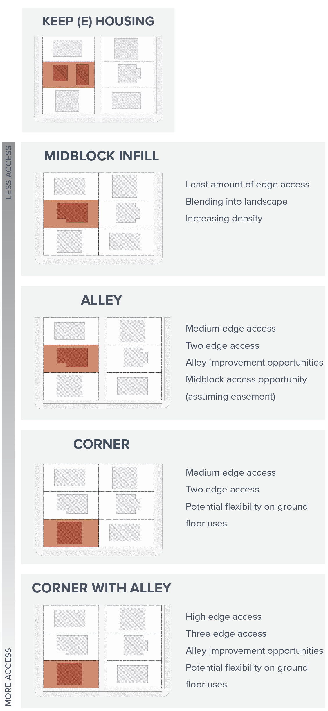
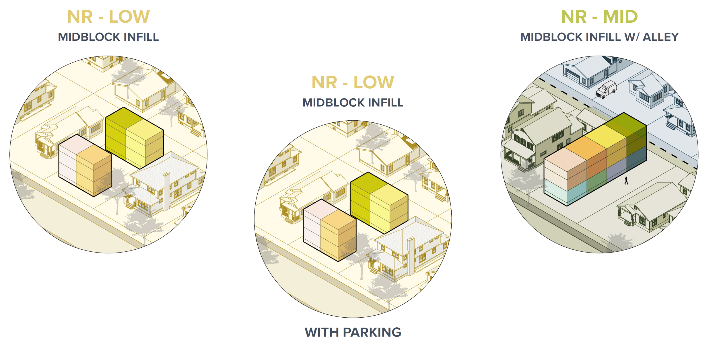
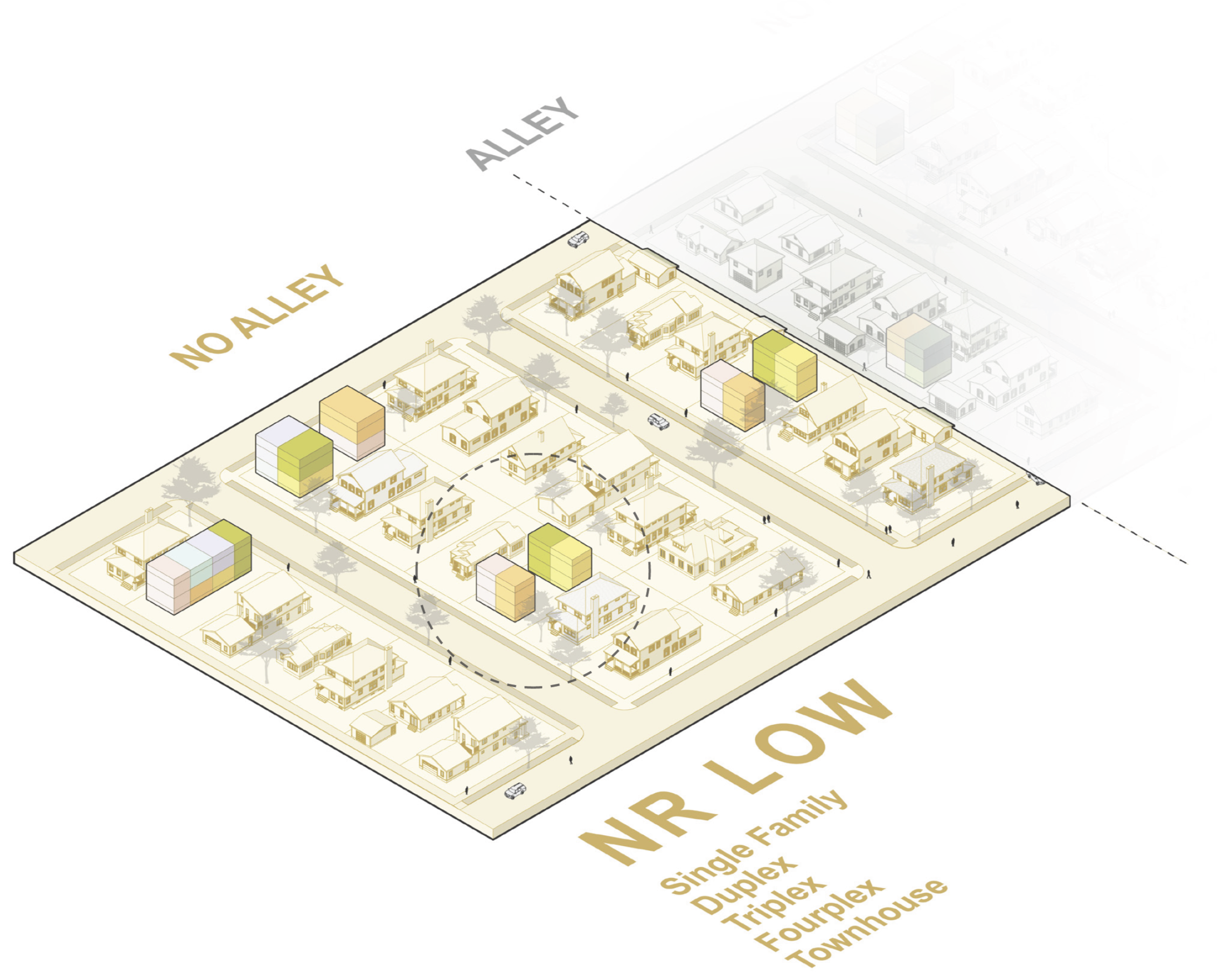
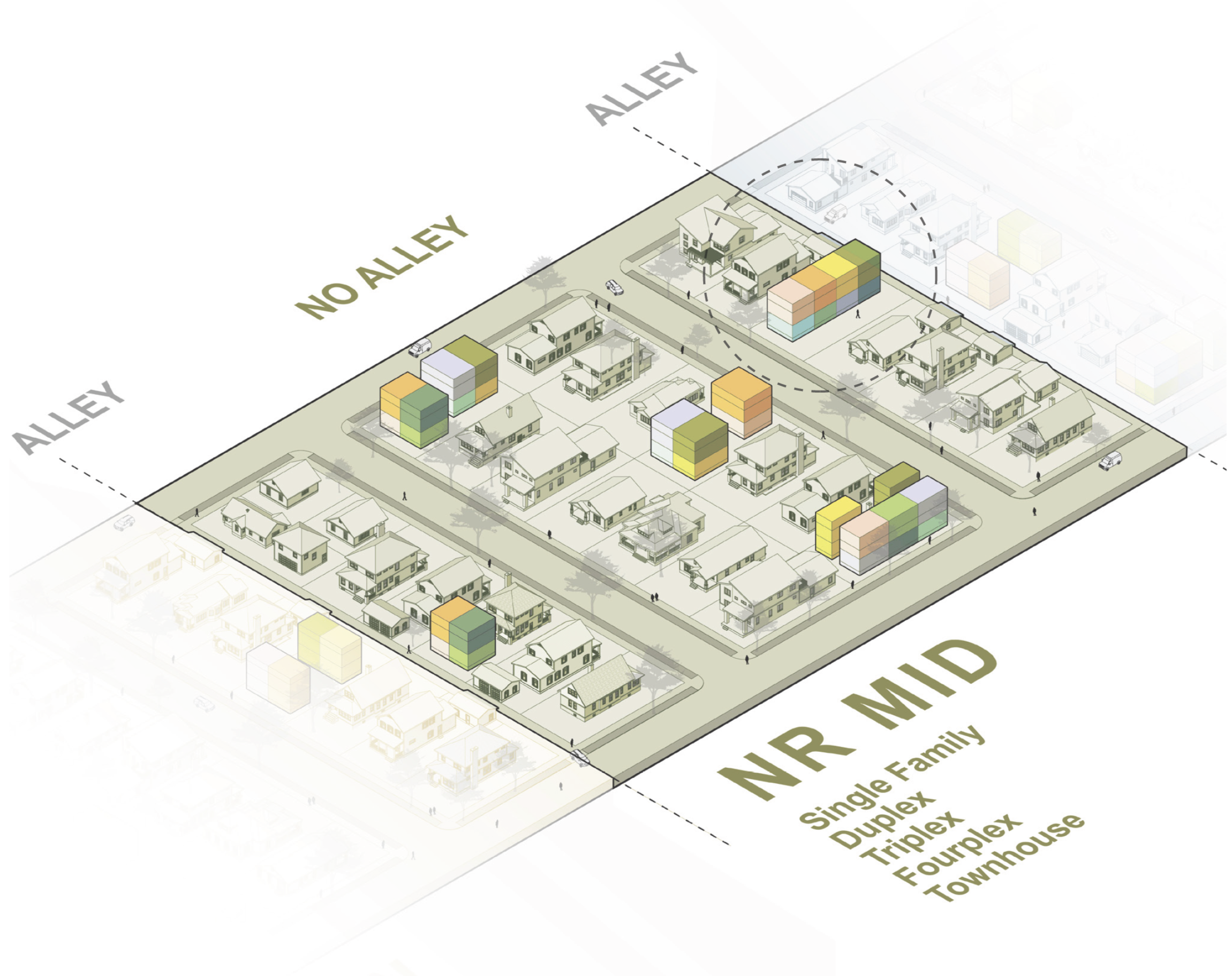
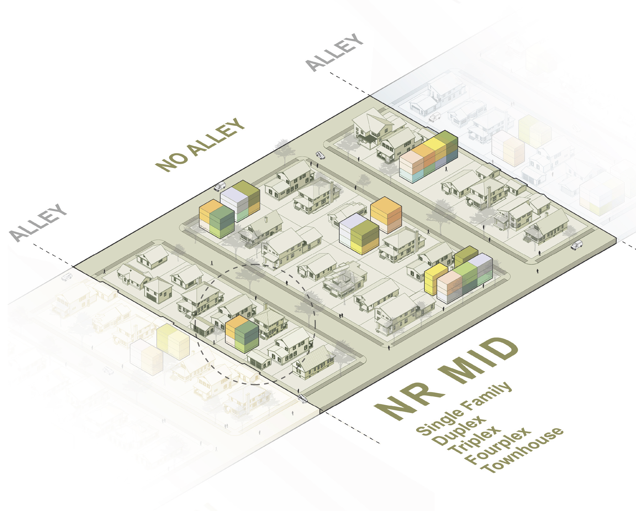
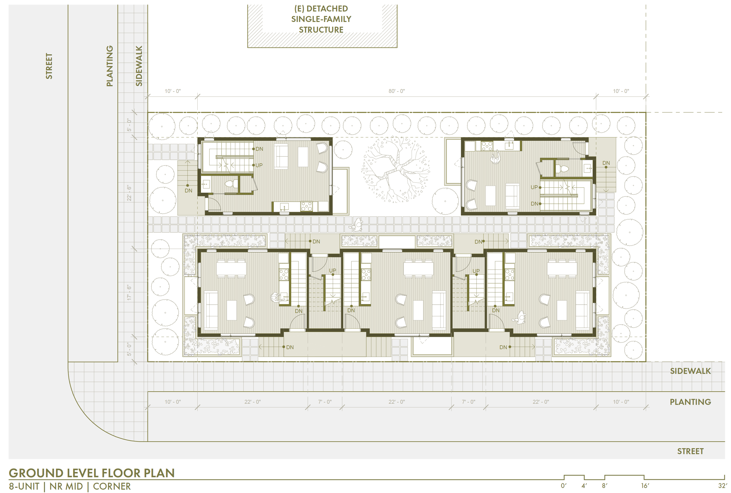
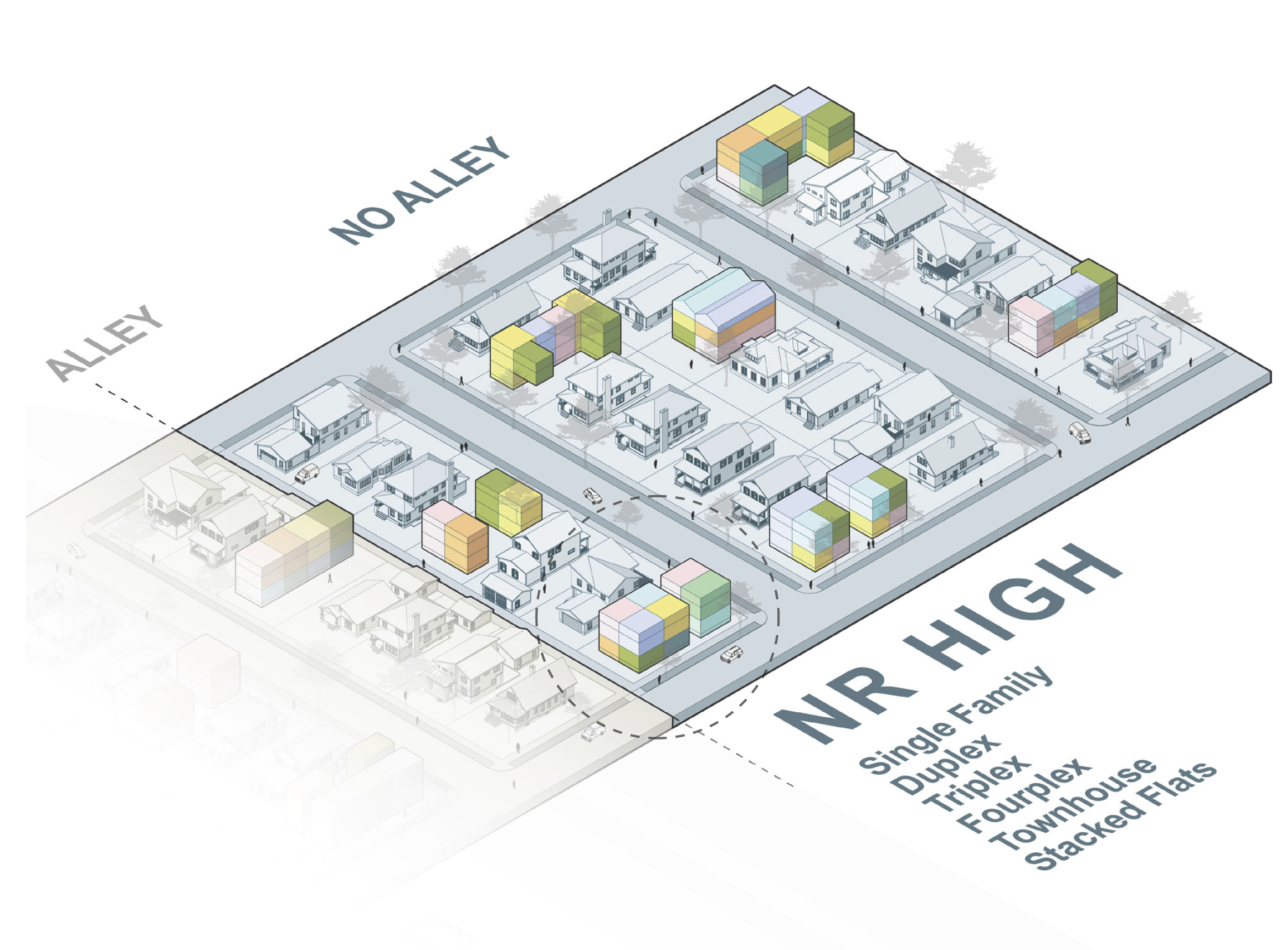
Analyzing the possibilities within different lot types and their opportunities for increasing housing diversity and density is important for various reasons. First, studying different lot configurations allows for an exploration of a variety of housing options. By examining four lot conditions: midblock infill lots, midblock infill lots with alleys, corner lots, and corner lots with alleys, there can be an understanding of varying degrees of access which can shape the design and regulatory approach for potential residential structures. Each of these lot types has various levels of access, which could influence regulations like maximum density and FAR. For example, midblock infill lots can be characterized by their narrower frontages and may necessitate inventive design solutions to optimize daylight, fresh air, and shared open space to accommodate additional housing units. Conversely, corner lots provide greater flexibility in terms of design and layout, as they have longer frontages facilitating heightened density and larger structures due to more inherent access to sidewalks, daylight, and fresh air.
The presence of alleys further increases the opportunities for increased density and FAR. Midblock infill lots with alleys allow for a second frontage for dwelling entries, parking, or shared amenities. Corner lots with alleys have even greater accessibility, facilitating the most possibilities for circulation, residential entries, parking, and outdoor spaces. These characteristics collectively enhance the functionality and possibilities of housing diversity in detached single-family neighborhoods.
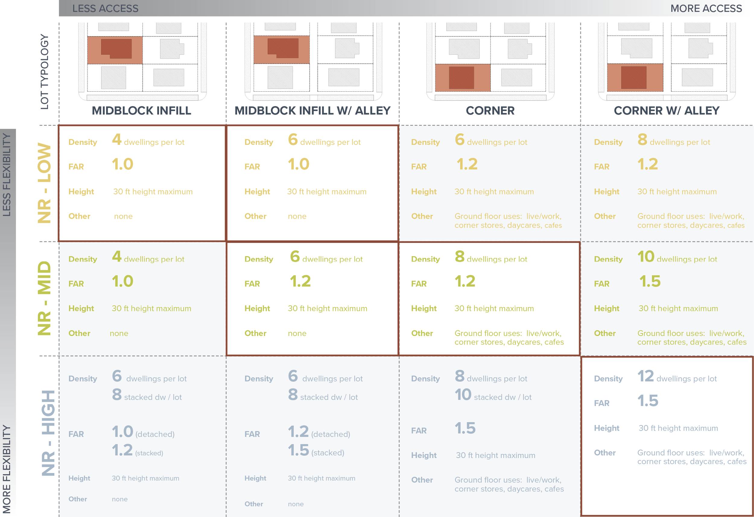
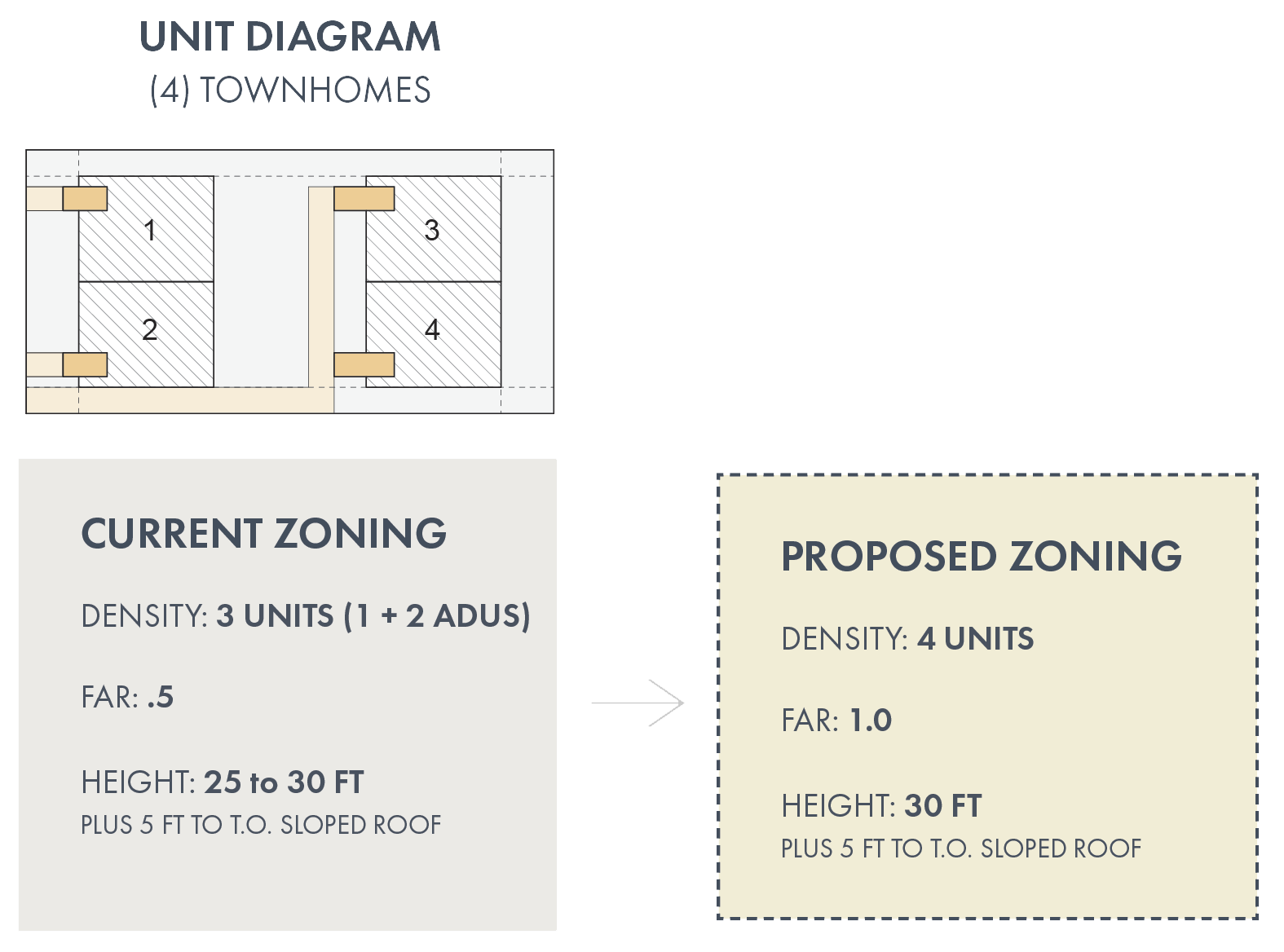
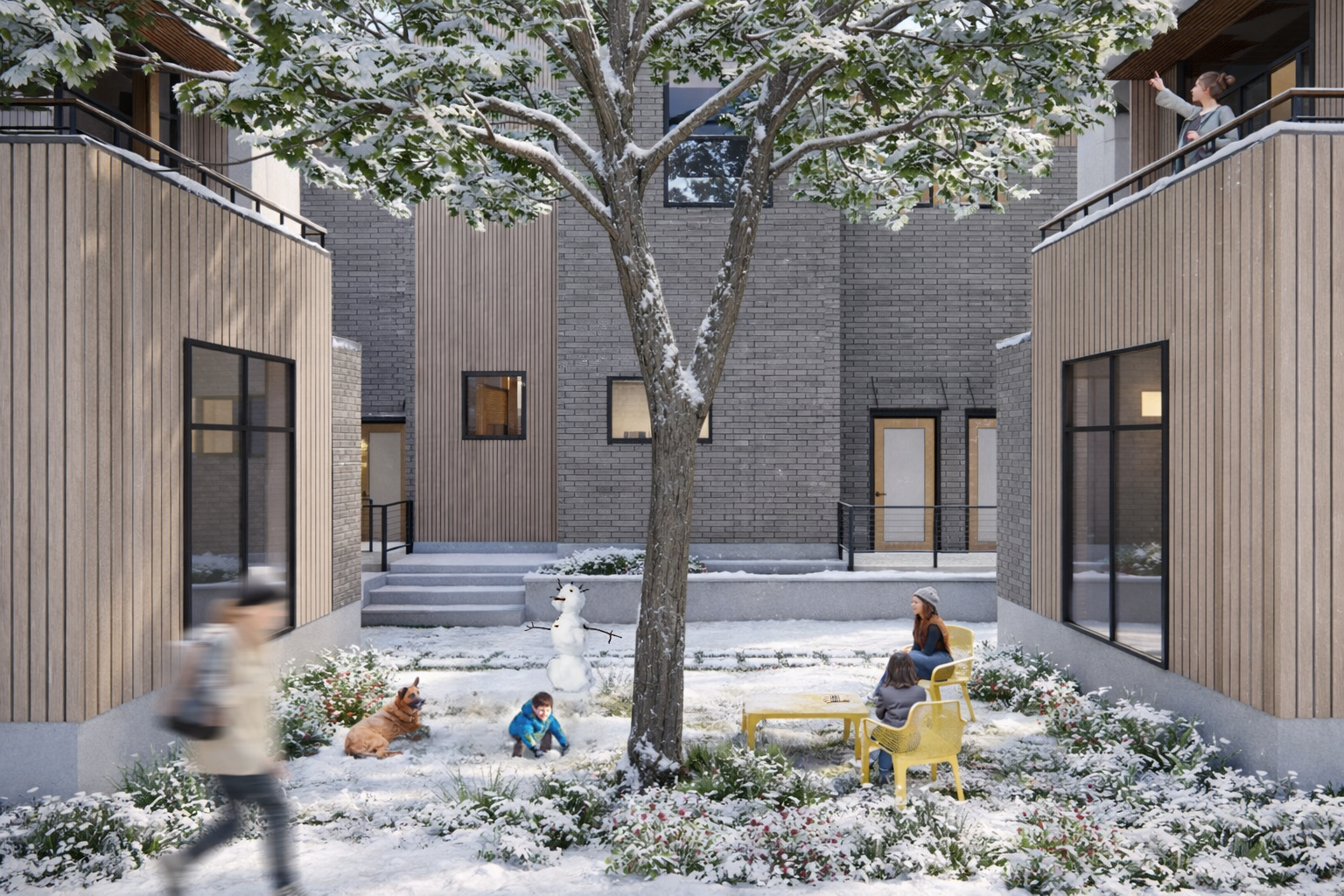
By analyzing lot variability and its implications for density and FAR, tailored strategies can be devised for each condition. This allows us to take advantage of existing low-density neighborhoods to create housing options that amplify density, equity, and diversity and foster a cultivation of diverse and sustainable communities. However, considering the possibility of retaining existing housing structures while adding density on the same lot is also critical for approaching increased density sustainably. It is well understood that “the greenest building is. . . one that is already built.” (Elefante, 2007), thus it is important to consider the integration of new housing units without sacrificing the existing housing stock for both environmental and displacement concerns. This approach proves particularly advantageous on lots with alleys, as it enables new units to have frontages and contributes to an improved and less car-centric alley space. In cases where alleys are absent, pathways can be created using the side yard setback to access new housing structures that can be constructed behind the existing single-family home. This strategy fosters even more diverse housing options. Using this framework, this thesis created a matrix that offers zoning suggestions for each lot type in the three Neighborhood Residential (NR) zones: Low, Mid, and High. The matrix outlines recommended maximum density, floor area ratio (FAR), height restrictions, and other possible considerations for ground-level uses. By customizing zoning suggestions to specific lot types, the thesis aims to optimize land use and promote suitable levels of density and development in each zone, taking into account lot possibilities. After developing the matrix of zoning recommendations, this thesis then examined six housing design options, one in each lot type and NR zone, as well as one focused on preserving existing housing stock and integrating considerations for possible ADA incentives. Exploring diverse design options is critical as it discovers potential housing outcomes in terms of functionality, aesthetics, and accessibility. By analyzing various design approaches, the thesis aims to identify innovative solutions that cater to the needs of diverse populations and contribute to a more inclusive and equitable city.
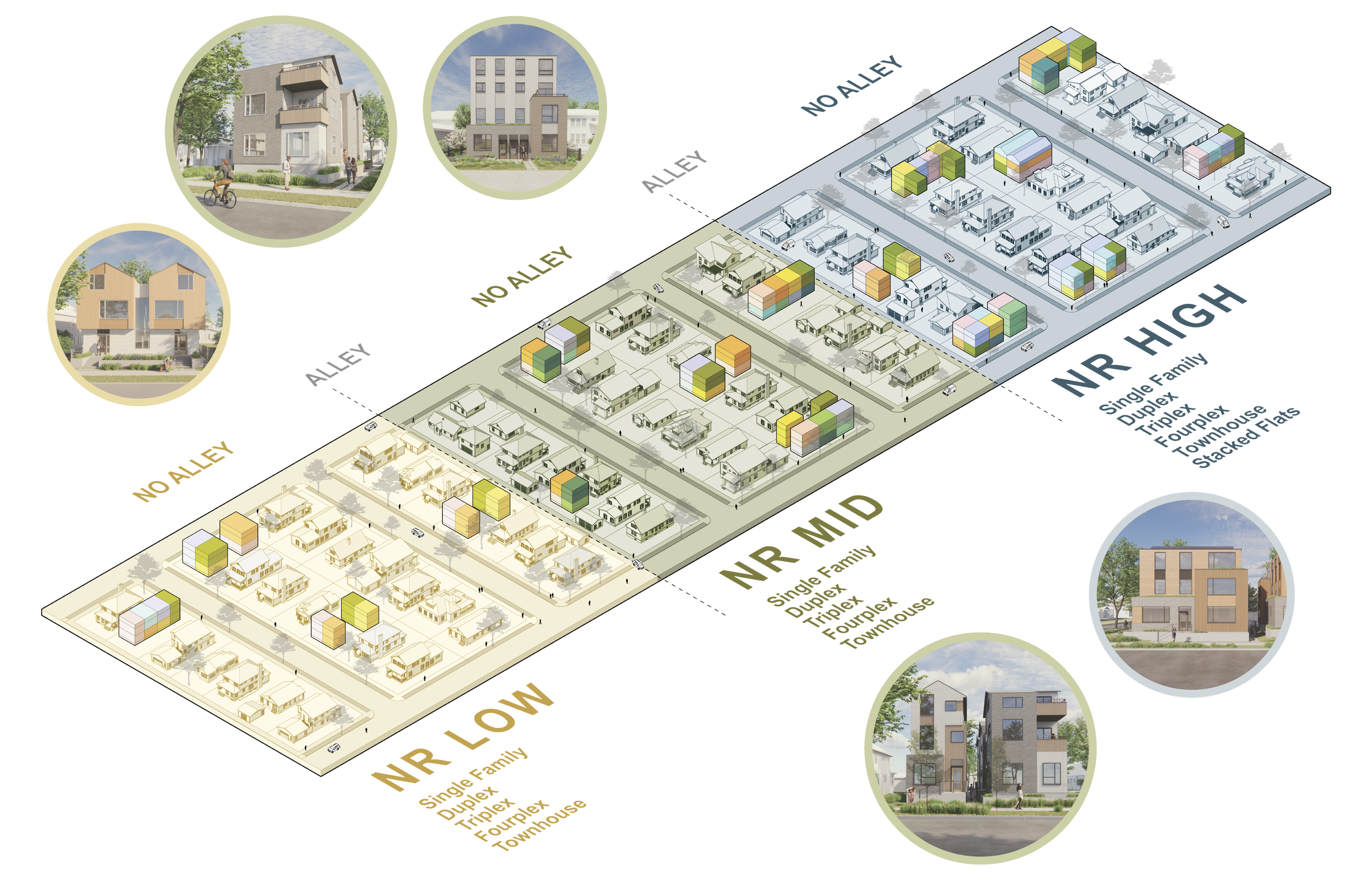
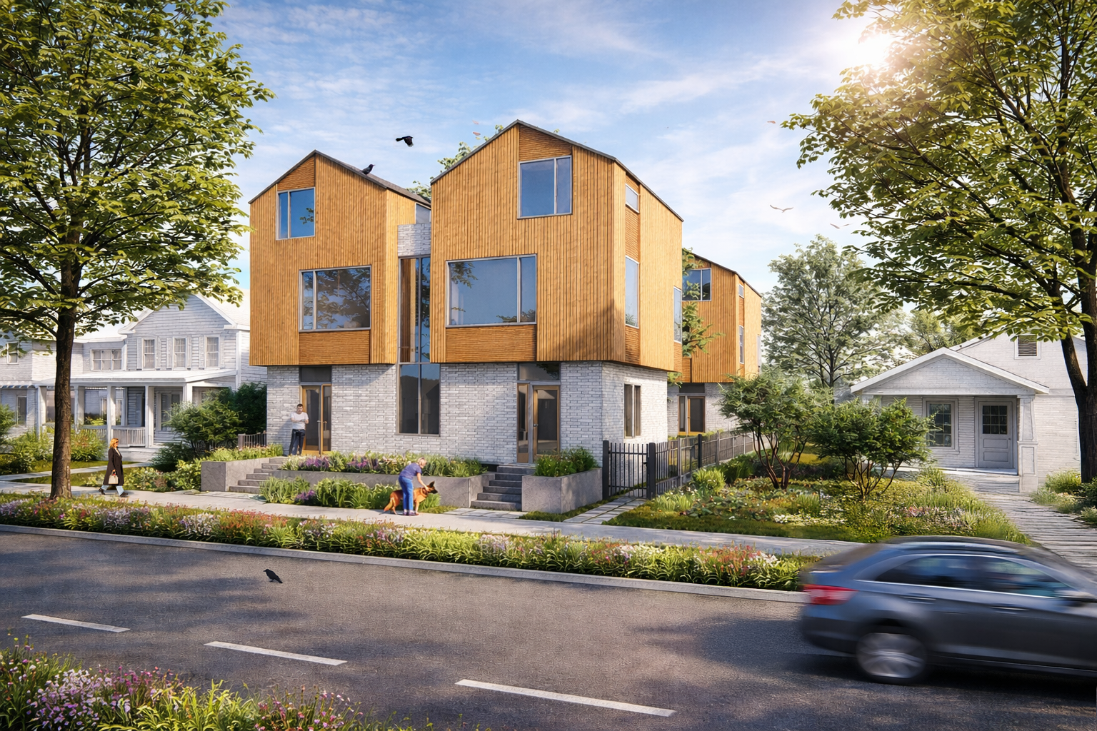
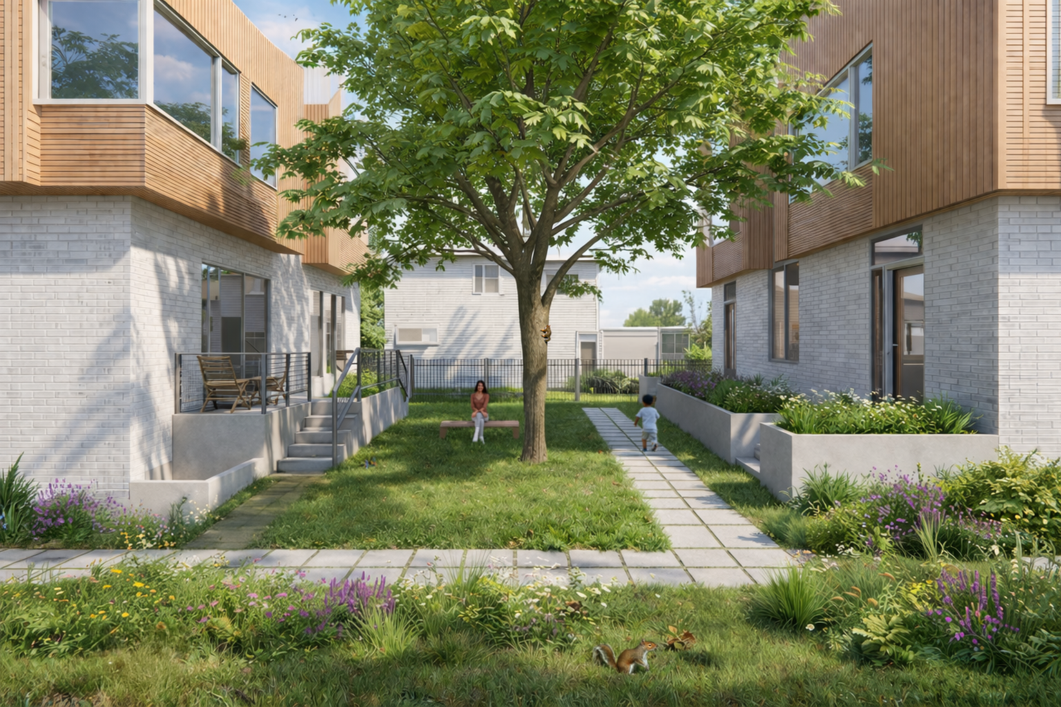
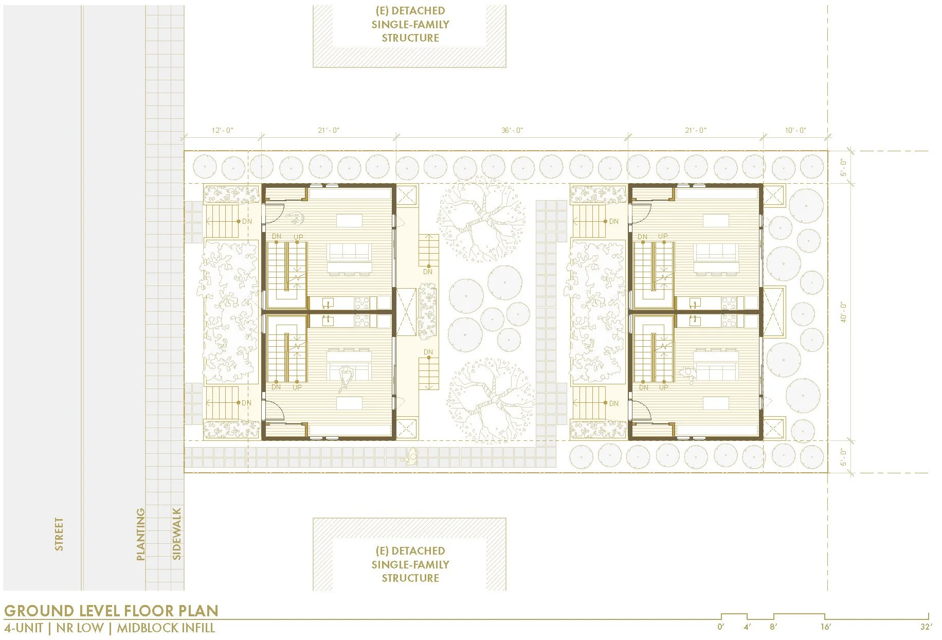
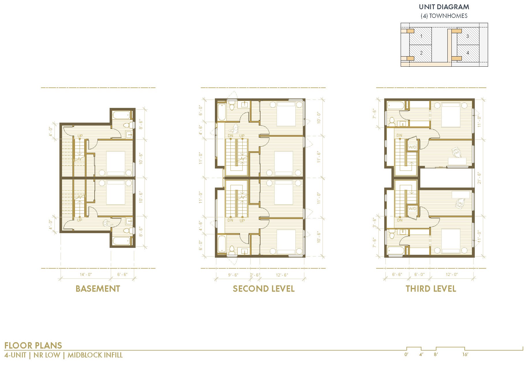
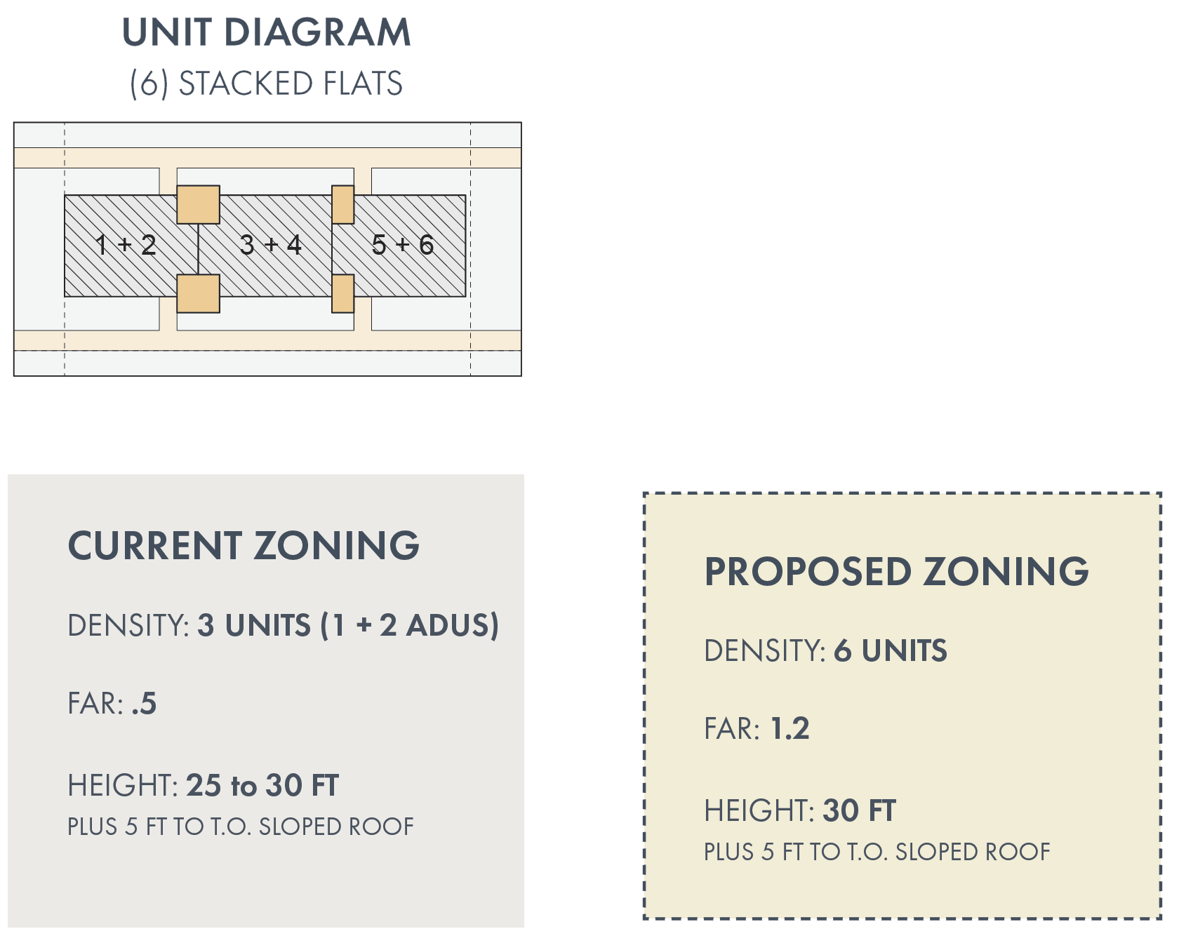
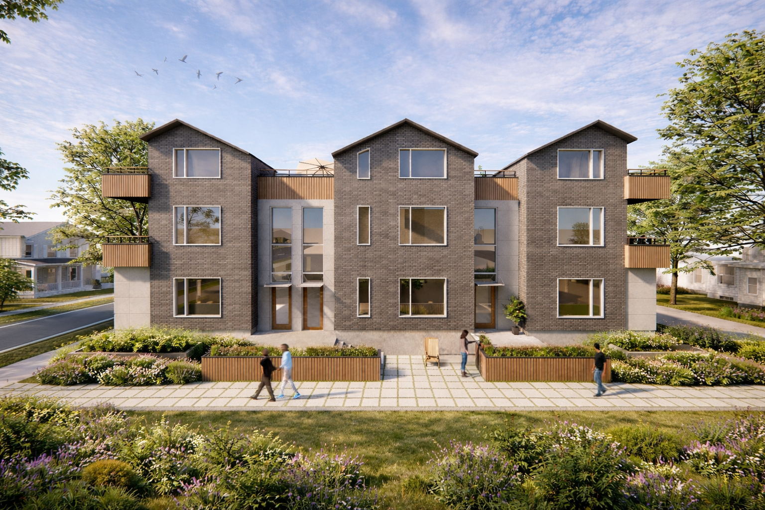
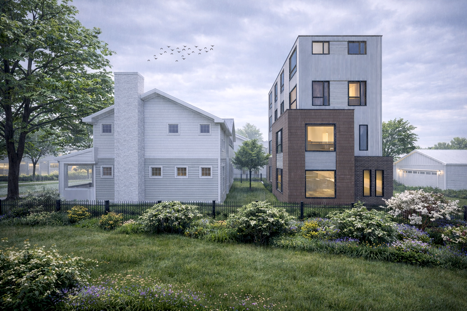
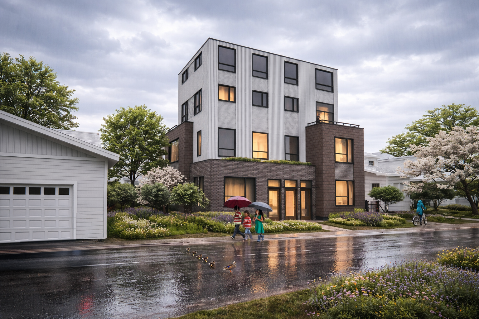
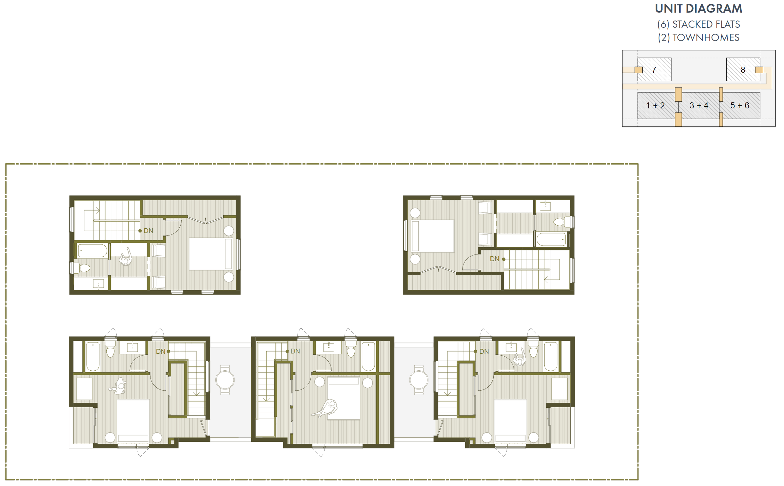
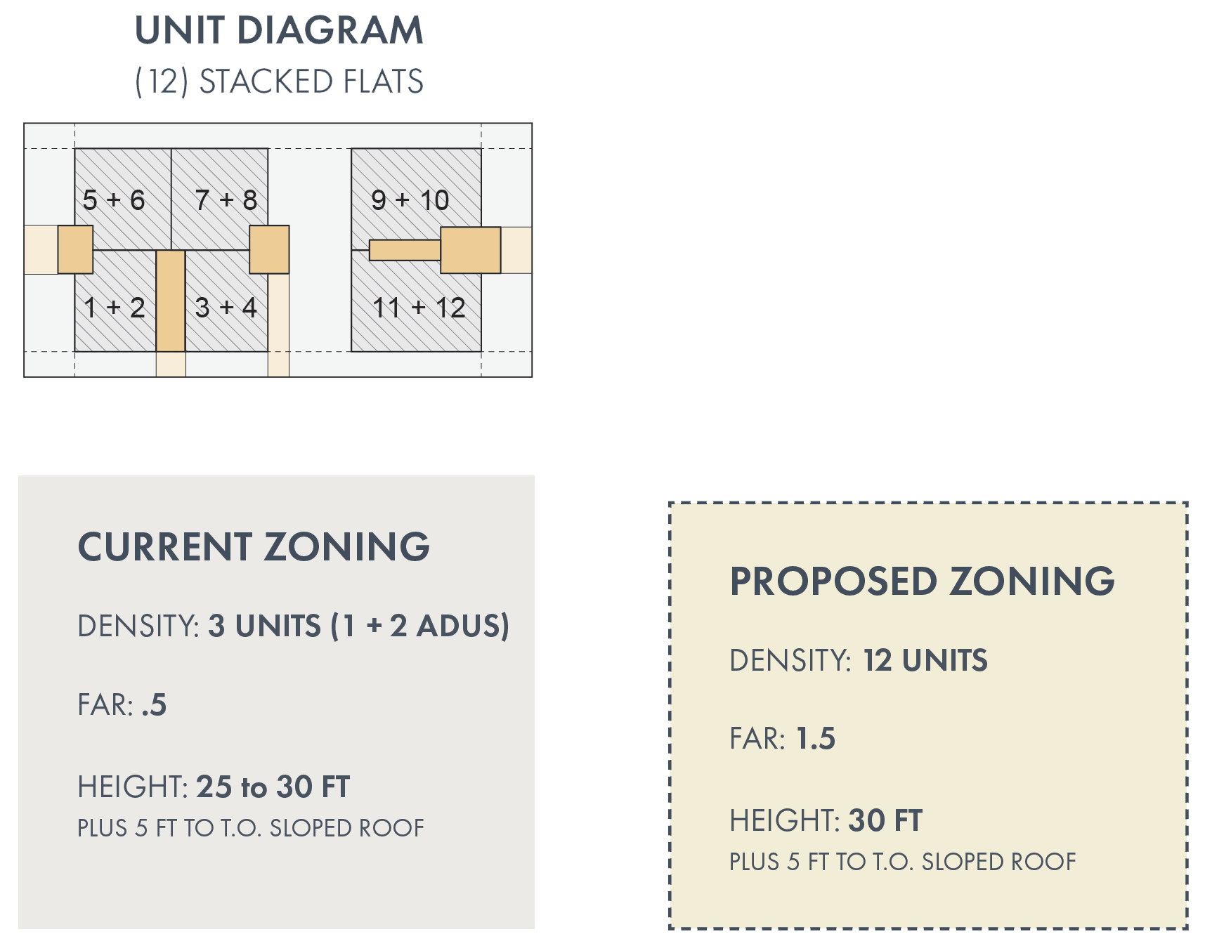
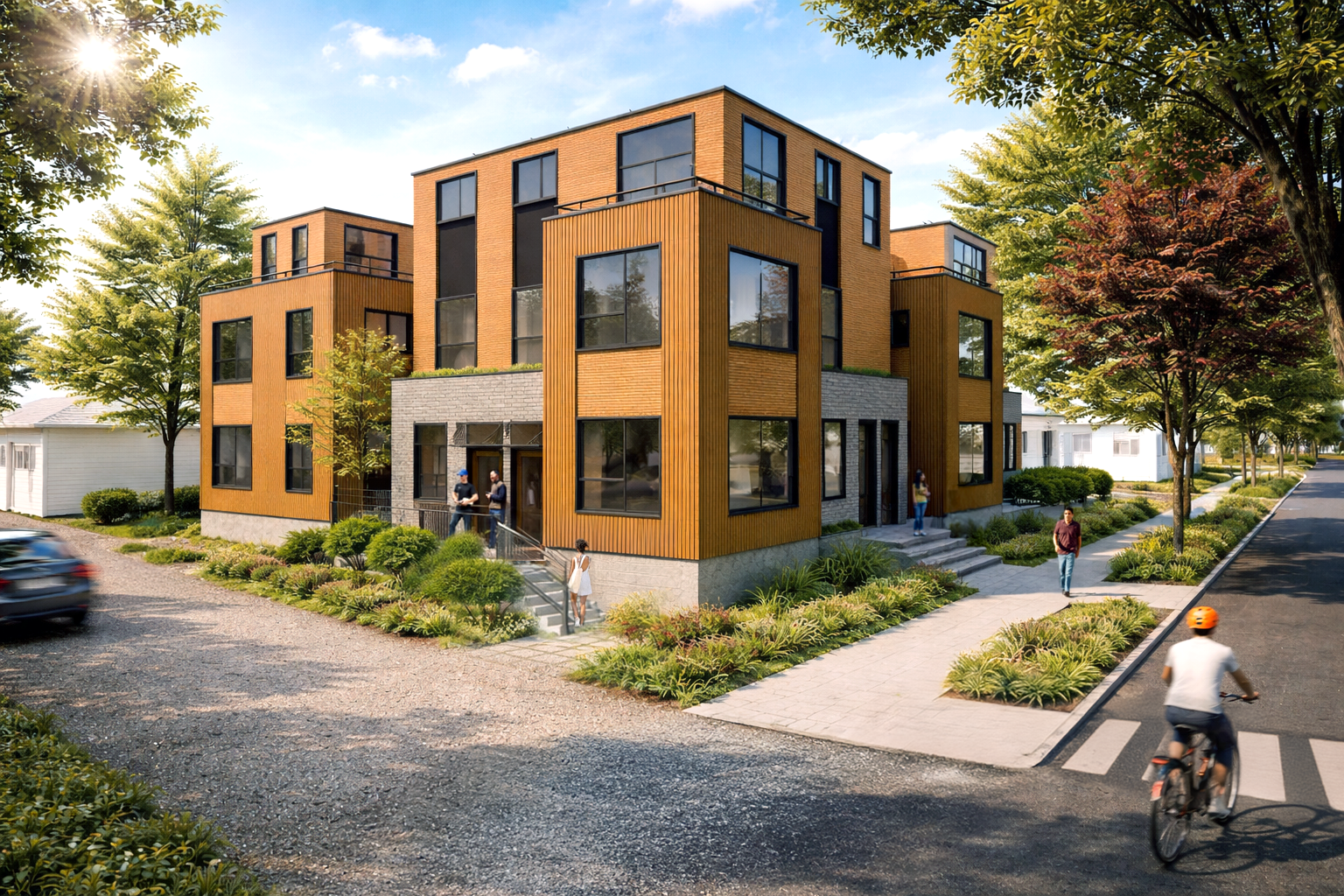
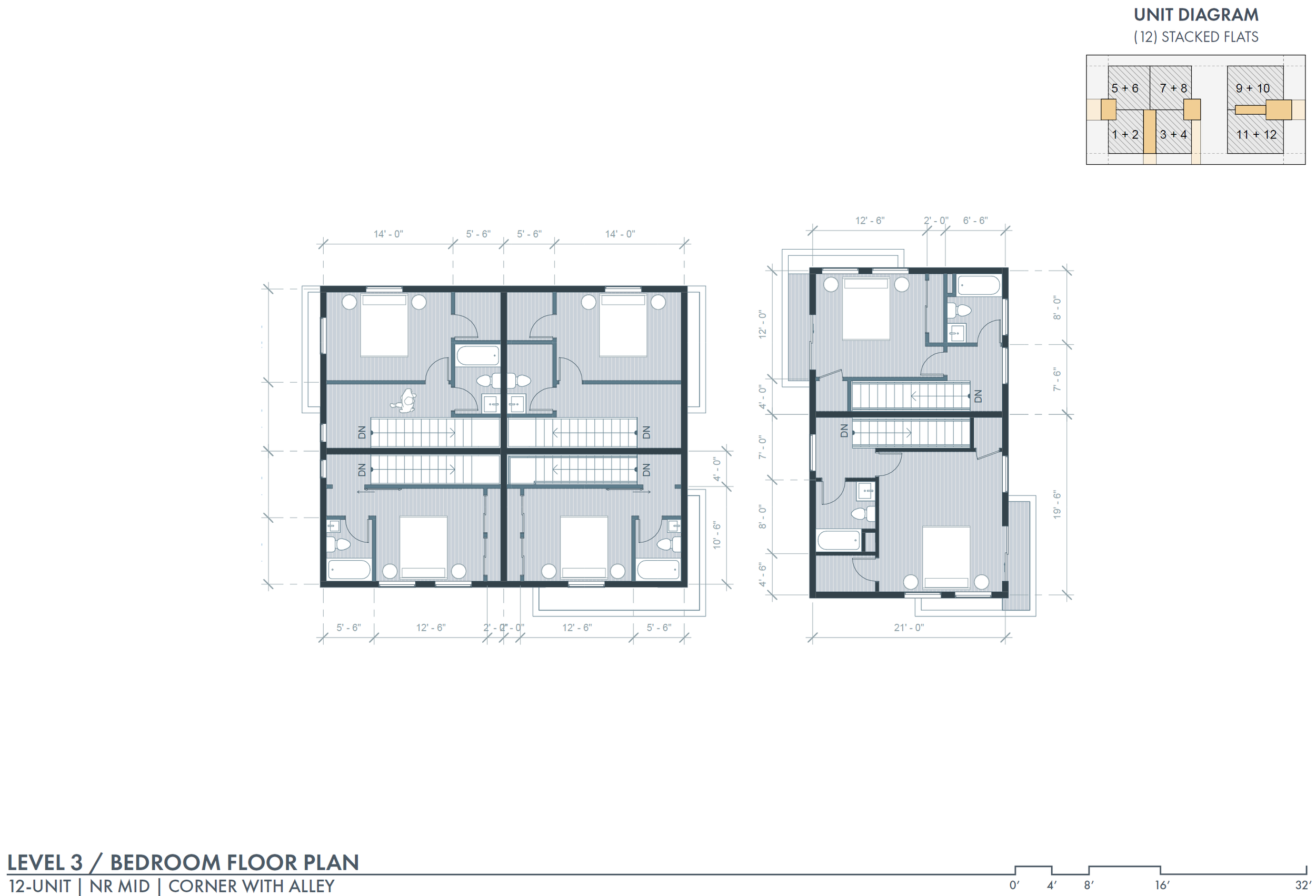
The development of the six housing design options began by developing a series of massing studies, which helped determine the most effective utilization of space, natural sunlight, fresh air, and general access for each lot. Various arrangements and configurations were explored to optimize land usage while adhering to the developed matrix of regulations. Following massing, the design process focused on dwelling adjacencies to ensure that each unit’s experience had good visual and physical access to green space and views outward. Consideration was given to the placement of windows, balconies, and shared spaces. By strategically arranging units in relation to one another and considering site orientation, the designs aimed to create a cohesive living environment that fosters a strong connection to its surroundings. Each design option provides a diagram of context, a unit diagram demonstrating access and paths to each unit, current zoning, proposed zoning, unit floor plans, as well as various renderings. The stacked flat units are all two-story dwellings with living spaces on the entry-level and bedrooms on the upper or lower level.
It is important to acknowledge that while this thesis presented six housing design options, the range of possibilities and variations not shown is extensive. Each design option serves as an illustration, highlighting one potential outcome among numerous alternatives. The design process embraces the possibilities and limitations of each site and responds to the developed matrix. This approach offers a view into what typologies could potentially be developed by designers once the city re-zones its NR areas.
OPCD’S 2024 COMPREHENSIVE PLAN MAJOR UPDATE
SEATTLE NEIGHBORHOOD TRANSECT THROUGH EVOLVING NEIGHBORHOOD RESIDENTIAL (NR) ZONES, AND EXISTING DENSER ZONES (LR, MR)
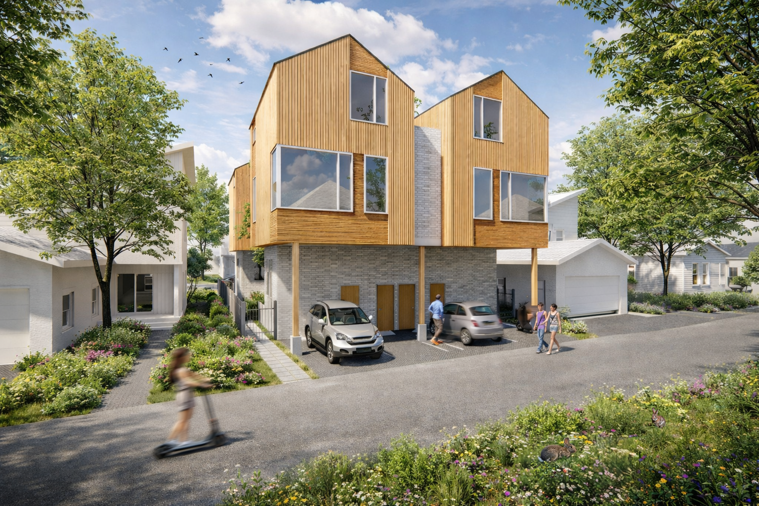
NR - LOW | Midblock Infill | 4-UNIT
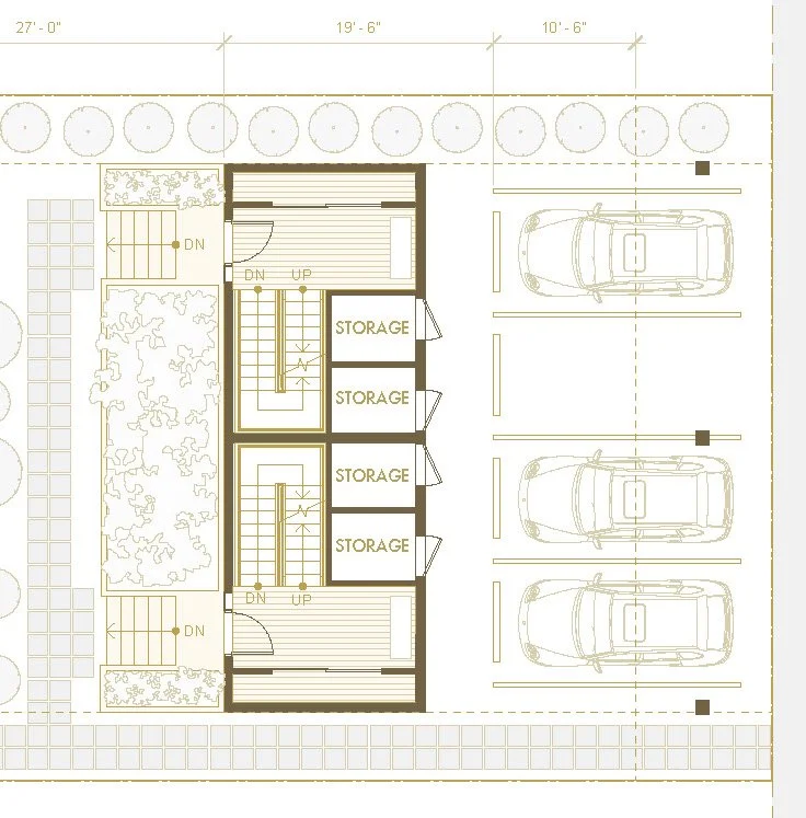
Alternative Alley Structure with Parking
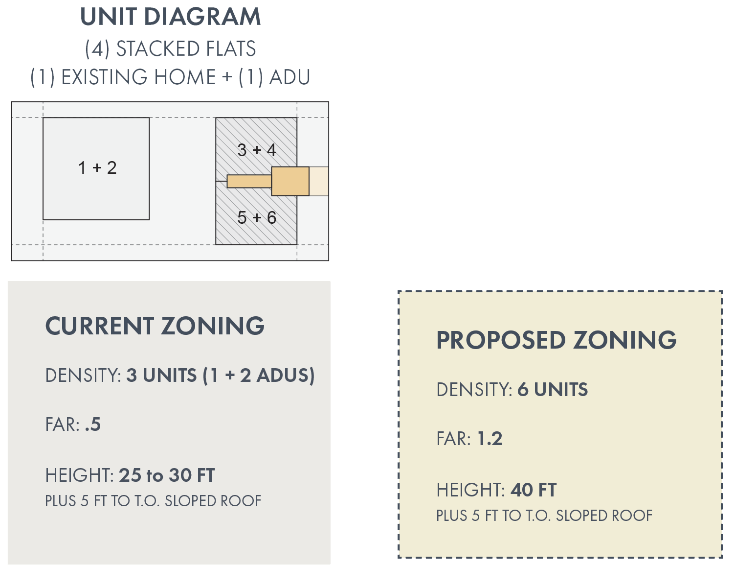
NR - MID | Midblock Infill w/ Alley | 6-UNIT
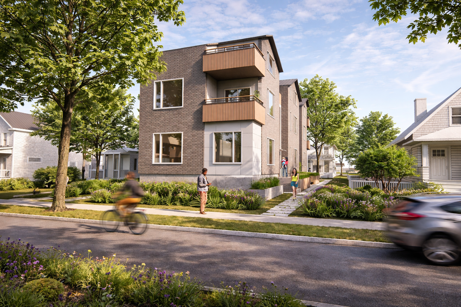
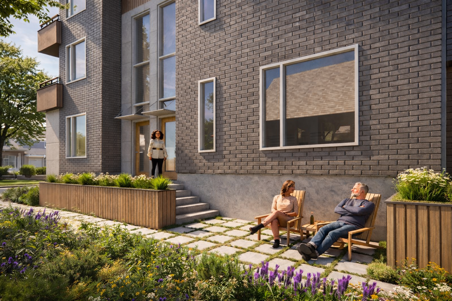
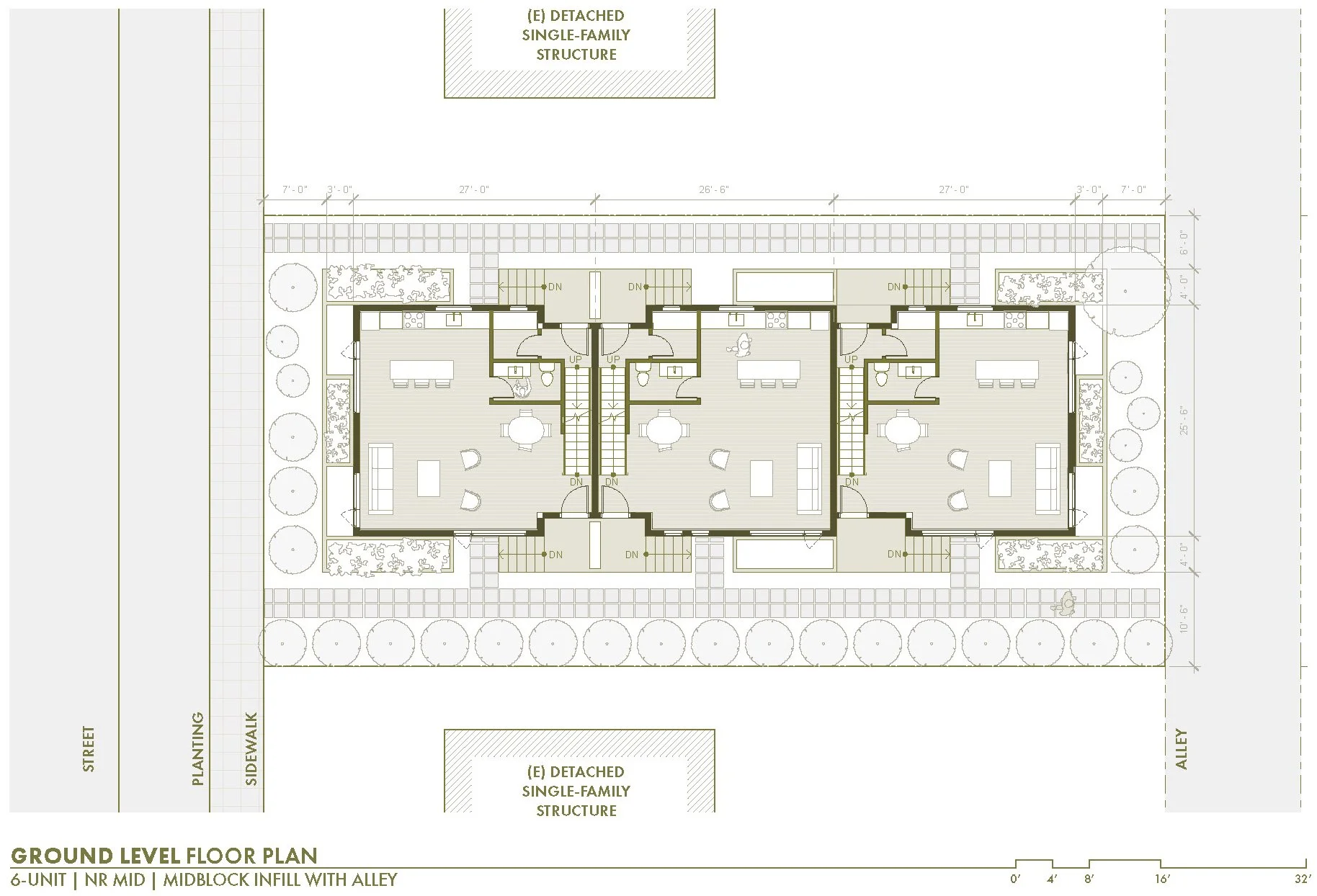
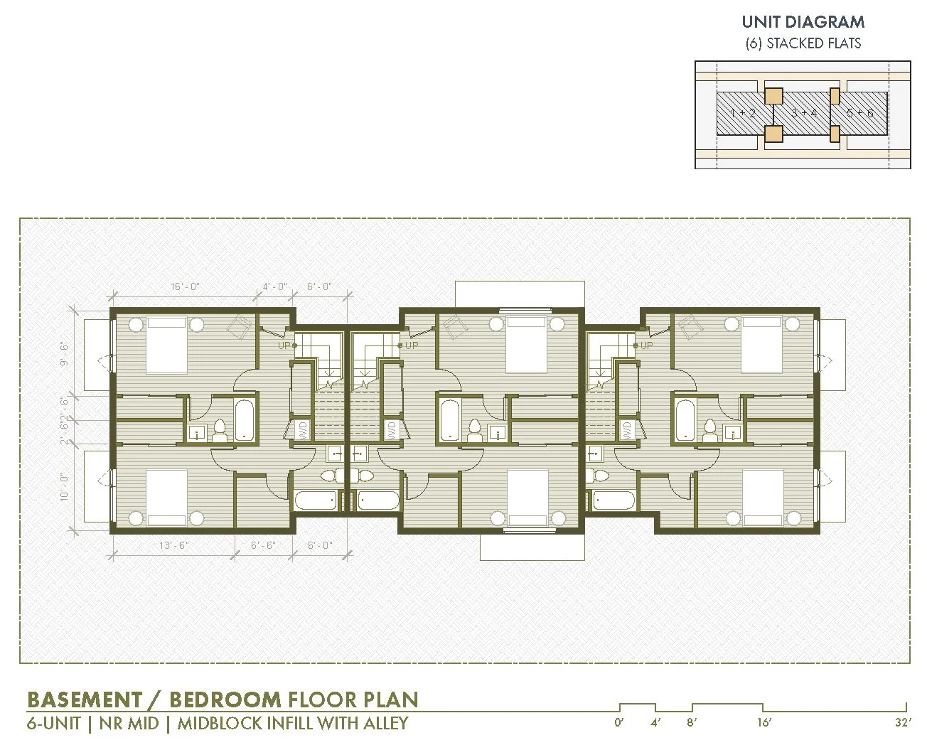
NR - MID | Midblock Infill with Alley
Keep existing housing + ADA | 6-UNIT
ADA Height Incentive
Considering incentives for ADA accessibility when developing new regulations is vital for promoting equal access and inclusivity in housing design. Developers often prioritize maximizing floor space, often leading to basement floors. This can result in non-ADA-accessible units due to the need for stairs to access the elevated ground level required to bring in daylight into the basement floor. To address the potential lack of ADA accessibility in new housing structures, it is crucial to explore ADA incentives.
One potential incentive is to allow for increased building height when the basement floor level is eliminated. This approach involves keeping the finished floor level of the ground floor at grade, making it ADA-accessible. This would work in situations where stacked flats are pursued, where the above floors would serve as a separate dwelling unit. The extra height ensures that the developer has the incentive to provide the ADA unit, as they would not lose any occupiable floor space by eliminating the basement floor plate. By introducing ADA incentives, we can ensure that new housing structures cater to all individuals, including those with mobility impairments.
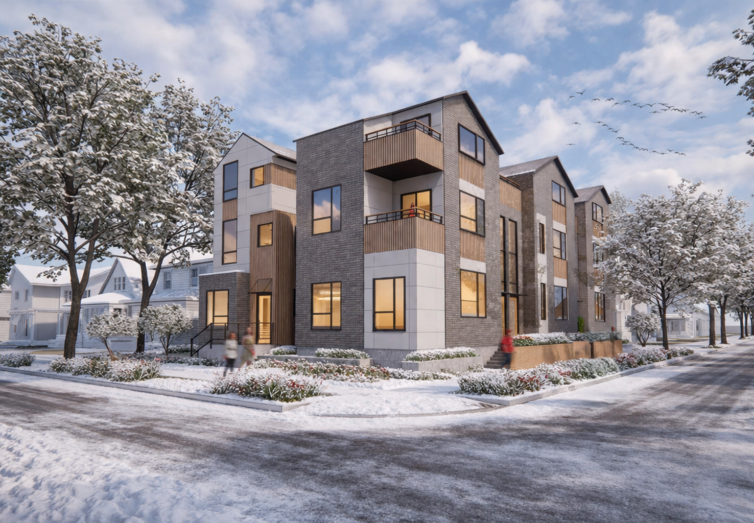
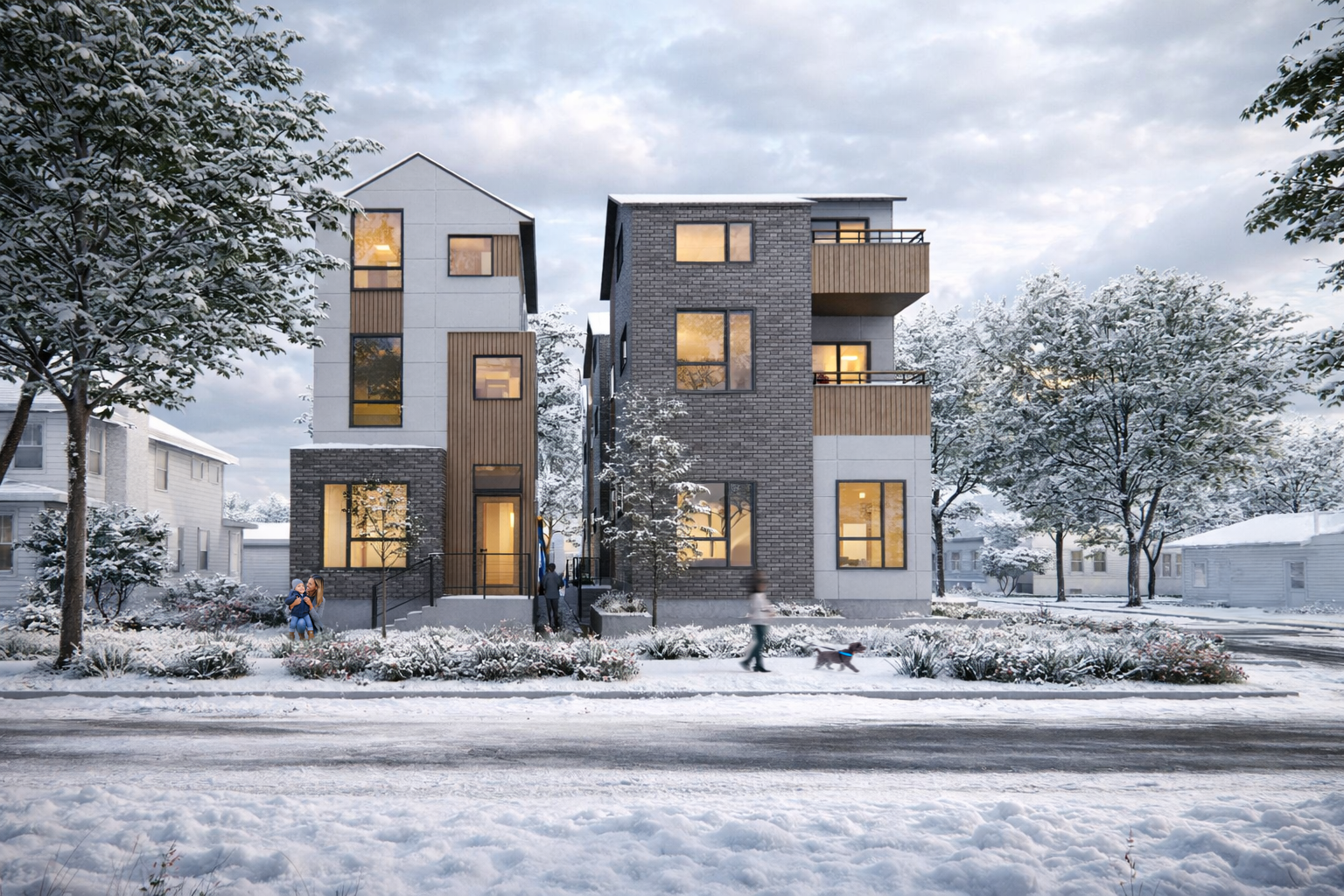
NR - MID | Corner | 8-UNIT
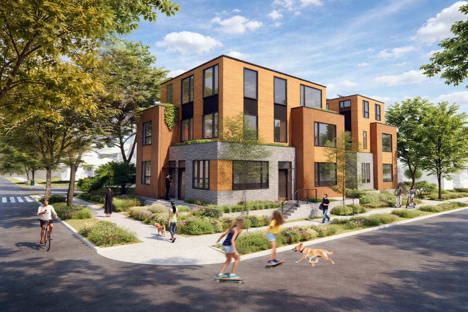
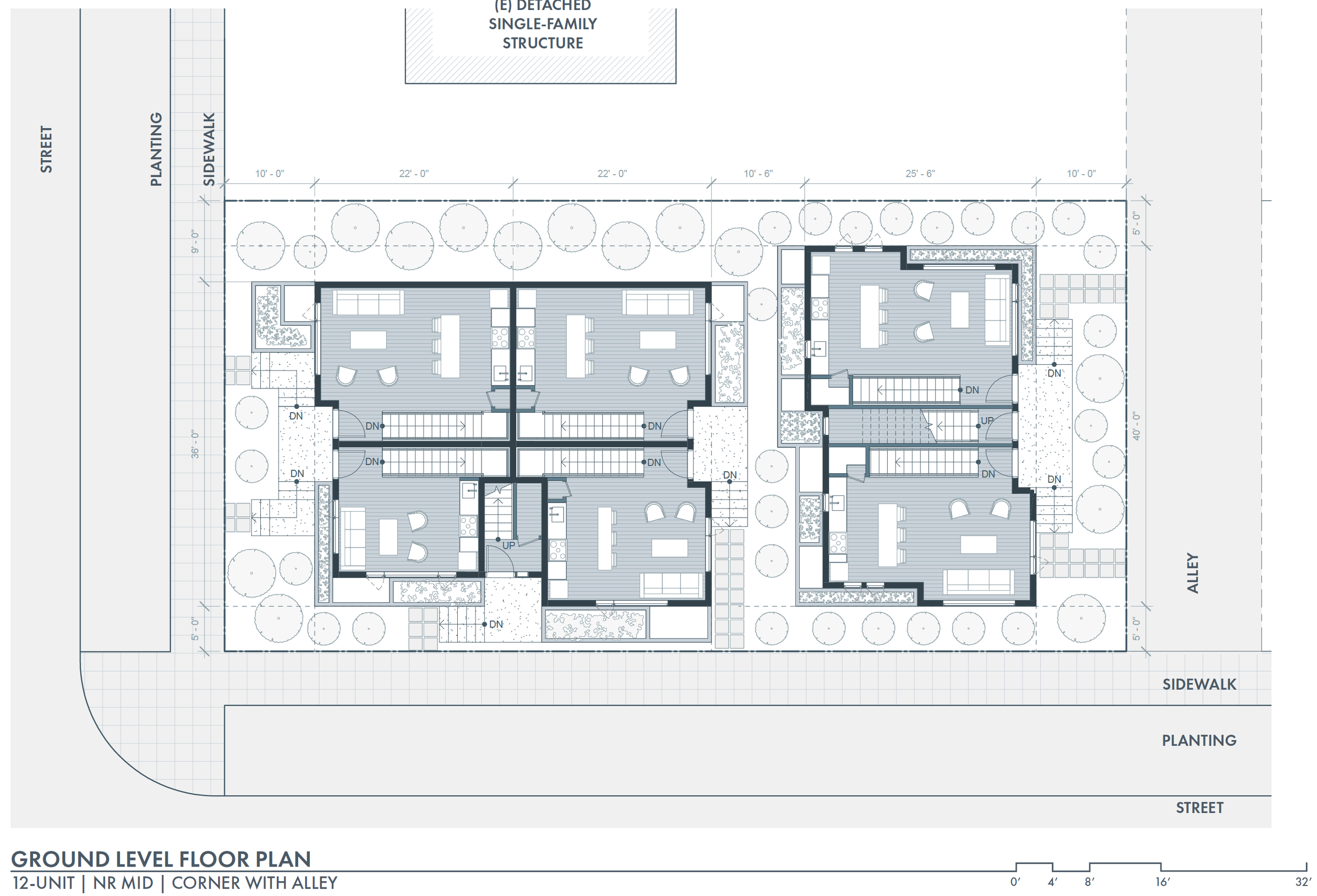
NR - HIGH | Corner with Alley | 12-UNIT
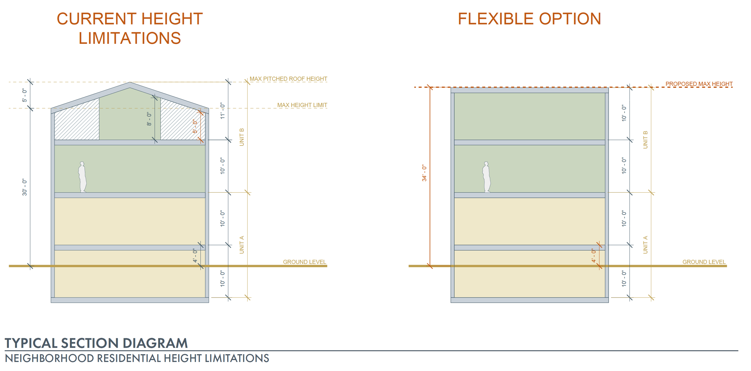
Density Height Incentive
Similar to increasing the prevalence of ADA units, high-density units may also need additional consideration to provide construction incentives. The current limitation of 30-foot maximum building height, with an additional 5 feet for pitched roofs creates a challenge when occupying the top floor. About two-thirds of the top floor in pitched roof structures is unoccupiable due to head height clearances. This restricts the usable floor area of the top floor of stacked flat units which rely on the extra height allowed by pitched roofs. Consequently, this leads to reduced livable spaces and fewer bedrooms in the upper units of stacked flats. Additionally, smaller unit sizes can pose difficulties as they may not adequately meet the needs of families.
To overcome these issues, this thesis proposes the consideration of density incentives within Neighborhood Residential (NR) zones. These incentives would allow units to reach a maximum height of 30 feet, plus the distance between the finished floor of the ground level and the average grade. In the case of this diagram, this would be a maximum of 34 feet, without a pitched roof. Eliminating the pitched roof would optimize the efficiency of stacked flat units, facilitating the inclusion of family-sized units. IT would also enable the replication of floor plans between lower and upper units, maximizing space utilization and providing for economical designs.
Additional Considerations
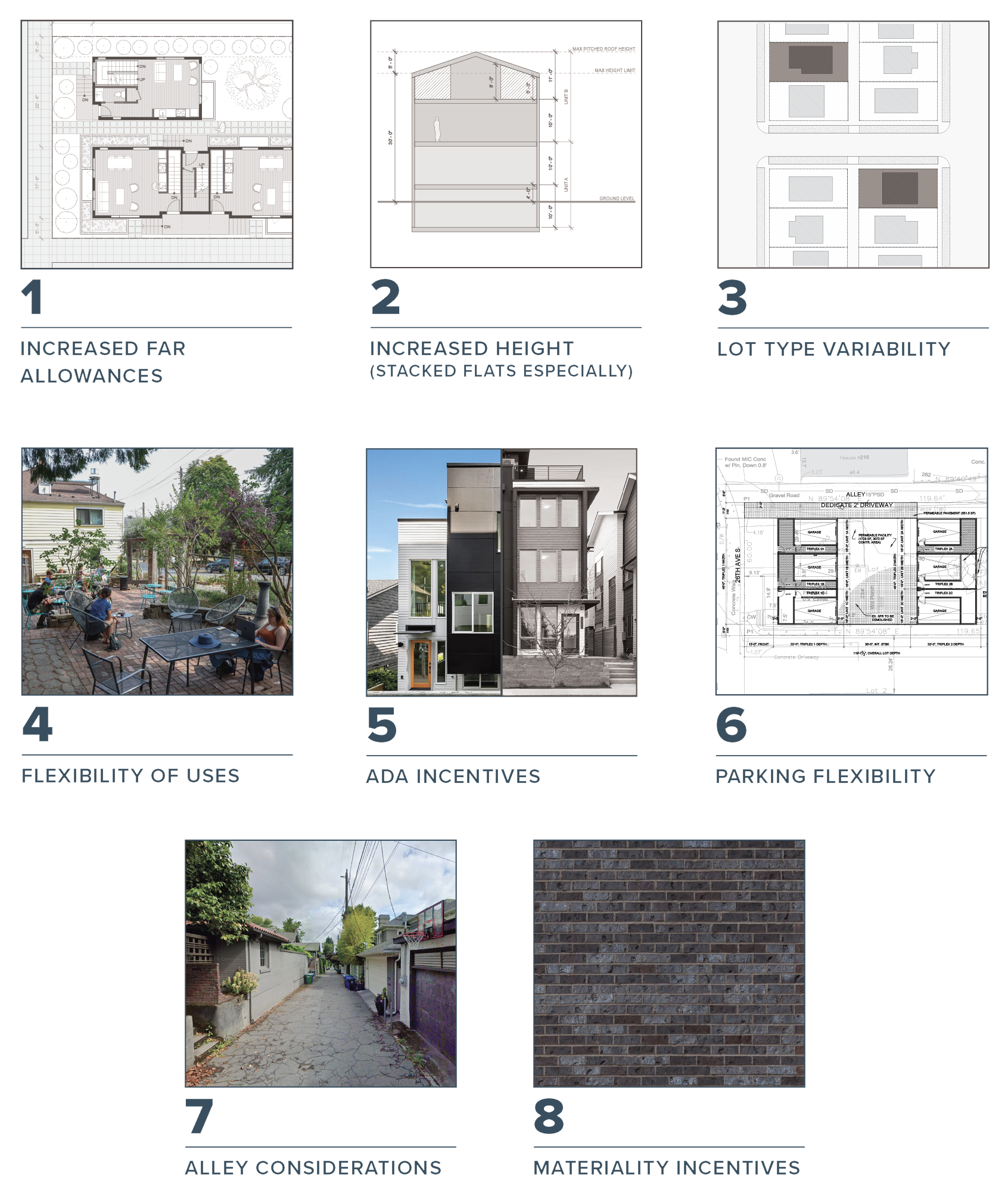
Developing a range of housing design possibilities in existing detached single-family neighborhoods is essential for envisioning the opportunities and challenges for increasing neighborhood density and providing equitable, diverse, and affordable housing choices. By exploring various design approaches, housing solutions can cater to a wider population. This ensures that housing can be more accessible. However, to achieve greater housing equity and diversity in Seattle, it is crucial to consider a wide variety of strategies. Minneapolis’ linear approach to density has limited their new housing production, and in contrast, Portland’s multi-scaled approach has seemingly been more successful. Key factors that Seattle should consider for the future of Neighborhood Residential (NR) zones include increased floor area ratios, increased height maximums, lot type variability, flexibility in ground-level uses, ADA incentives, elimination of parking requirements, alley considerations, and materiality incentives. First, allowing for higher floor area ratios can help with the construction of multi-family structures on small lots, and can help increase housing capacity. Allowing for increased height is especially important in stacked flat units, as reconsidering maximum height allowances can provide more housing options and increase the number of bedrooms in top-floor units. Lot variability can be very important when considering the opportunities that different lot types afford, and can encourage diverse housing options. Allowing flexibility in ground-level uses by incorporating small coffee shops or community spaces can enhance neighborhood vibrancy, and livability while supporting local businesses. This can bolster the idea of the 15-minute city, and provide a framework for more sustainable neighborhoods in Seattle. Reducing parking requirements can also promote alternatives to car-dependent lifestyles and enhance walkability to support sustainable urban development as well. Parking requirements often limit the amount of housing that can be constructed on a lot, so eliminating this like Portland has done can also increase the construction of new housing. Alley considerations can enhance the human experience by exploring how housing frontages adjacent to alleys can improve the vibrancy and opportunities within alleys. Lastly, materiality incentives could help the perceived impact on human scale development, and increase the visual appeal of new neighborhood development.
5 | Findings + Conclusions
Goals
The primary goals of this thesis have revolved around exploring and presenting diverse design options for housing in Seattle’s current detached single-family neighborhoods as a means to increase housing opportunities and envision Seattle’s future. The significance of this project is its potential to foster increased density, affordability, equity, and housing diversity. By embracing various designs and methods to approach increasing density, this thesis challenges conventional low-density housing development to demonstrate the possibilities of equitable neighborhoods. In doing so, housing scarcity is addressed, but also it envisions a more inclusive and socially dynamic urban housing landscape. The options and recommendations outlined in this thesis hold the possibility of offering insights to Seattle’s Office of Planning and Community Development (OPCD), which is currently engaged in the development of Seattle’s 2024 Comprehensive Plan Major Update. By considering these design explorations in their planning process, OPCD can have a better understanding of how new housing designs might unfold given the regulations outlined. OPCD has a unique opportunity to reshape historical patterns of racial inequity and segregation, and by recognizing the significance of housing equity as a central aspect of their next Comprehensive Plan Update, they can establish policies and regulations that better bolster the creation of inclusive communities. The ultimate aim of this project is to open a conversation and ongoing collaboration between academia, practitioners, and policymakers, all working together to influence the future of Seattle. By actively engaging with stakeholders, the goal is to shape the future trajectory of housing development in Seattle.
The zoning suggestions and additional recommendations outlined in this thesis are intended for Seattle’s Office of Planning and Community Development (OPCD) to consider during the city’s comprehensive plan update. It is crucial for the city to adopt an approach that takes into account a variety of elements beyond solely relying on increased density limits as the sole driver for diverse housing production in currently low-density neighborhoods. While density plays a significant role and requires increases, it is equally as important to acknowledge the influence of other factors in creating sustainable, equitable, and diverse communities.
The OPCD should prioritize the incorporation of design strategies that address quality and livability alongside increased density. This can include things outlined like increased FAR considerations, human-scaled alley considerations, and the shift away from vehicle reliance and parking minimums. By adopting a holistic approach to housing development, the city can foster vibrant neighborhoods that not only focus on maximizing density but also cultivate livability, diversity, equity, and a strong sense of place and community. By embracing these recommendations and adopting various strategies, the city can begin to mend historic patterns of segregation and inequitable planning practices in the built environment.
Sources | List of Figures
Figure A: Aerial view of downtown Seattle, looking north toward Lake Union, 1924. UW Image courtesy of University of Washington Libraries, Special Collections.
Figure 1: Graph showing National housing inventory and months of supply. Rep. The State of the Nation’s Housing. Cambridge, MA: the President and Fellows of Harvard College, 2022.
Figure 2: Graph showing Seattle’s annual new housing units lag behind annual population growth from 2005 - 2016. Seattle Planning Commission, “Neighborhoods for All: Expanding Housing Opportunity in Seattle’s Single-Family Zones, Fall 2018, 25.
Figure 3: Non-exhaustive list of effects caused by restrictive zoning polices, otherwise known as exclusionary zoning (including the protection of detached single-family neighborhoods).
Figure 4: Three-quarters of all the land that Seattleites can live on is zoned for single-family. Seattle Planning Commission, “Neighborhoods for All: Expanding Housing Opportunity in Seattle’s Single-Family Zones.” City of Seattle, 2018.
Figure 5: Households who cannot afford, or want a more affordable option are limited ot the areas of the city shaded blue-- those zoned for a mix of housing including multi-family zoning. Seattle Planning Commission, “Neighborhoods for All: Expanding Housing Opportunity in Seattle’s Single-Family Zones.” City of Seattle, 2018.
Figure 6: Households who cannot afford, or want a more affordable option are limited ot the areas of the city shaded blue-- those zoned for a mix of housing including multi-family zoning. Seattle Planning Commission, “Neighborhoods for All: Expanding Housing Opportunity in Seattle’s Single-Family Zones.” City of Seattle, 2018.
Figure 7: The type of housing a household occupies varies by race. Almost half of white non-Hispanic households live in detached one-unit structures. City of Seattle, “Accessory Dwelling Units: Final Environmental Impact Statement.” City of Seattle, 2018.
Figure 8: About 62 percent of Black residents have reported being housing cost-burdened, compared to about 30 percent of white residents. King County Department of Community and Human Services. The Regional Affordable Housing Dashboard, 2019.
Figure 9: Missing middle housing is a range of house-scale buildings with multiple dwelling units. This includes Duplexes, Triplexes, Fourplexes, Courtyard buildings, Cottage court buildings, Townhouses, Multiplexes, and Live-work units. Parolek, Daniel G. Missing Middle Housing: Thinking Big and Building Small to Respond to Today’s Housing Crisis. Amsterdam: Island Press, 2020.
Figure 10: Holmberg, John. “Car passing cacant houses on Capitol Hill.” Digital image. Mohai Museumof History & Industry, April 13 1982. Accessed June 8, 2023. https://digitalcollections.lib.washington.edu/digital/collection/imlsmohai/id/10009/rec/1
Figure 11: “Seattle, looking north.” Digital Image. University of Washington Libraries, Special Collections, [Order Number SEA1379, Negative Number UW2144], Between 1920 and 1950. Accessed June 8, 2023. https://digitalcollections.lib.washington.edu/digital/collection/seattle/id/555/rec/2
Figure 12: Heritage, Baltimore. “1885-1929: Segregation and the Fourteenth Amendment.” Baltimore’s Civil Rights Heritage. Baltimore Heritage Club, 2022. https://baltimoreheritage.github.io/civil-rights-heritage/1885-1929/.
Figure 13: Lighting Design and Application: LD and A. 16(6), Bryan, H. & Stuebing, S., Natural light as an urban amenity, 44-48, copyright 1986.
Figure 14: Detroit Publishing Co. Mulberry Street, New York City. Photograph. Library of Congress, Photochrom prints. ca. 1900. https://www.loc.gov/item/2016794146/
Figure 15: Harris, Kenneth. Aerial view of houses in Seattle, Washington, December 1947. Photograph. University of Washington Libraries, Special Collections. 1947. https://digitalcollections.lib.washington.edu/digital/collection/seattle/id/5596/rec/100
Figure 16: Graphic showing history of zoning in Seattle. Based on information from the Seattle Planning Commission’s Neighborhoods for All Report. Seattle Planning Commission, “Neighborhoods for All: Expanding Housing Opportunity in Seattle’s Single-Family Zones.” City of Seattle, 2018.
Figure 17: Seattle 1917 Building Districts Map. The Building Ordinances of the City of Seattle, the City of Seattle. The Seattle Municipal Archives. § (1917). http://clerk.seattle.gov/~F_archives/documents/Doc_18.pdf.
Figure 18: Downtown Seattle in 1911. “First Avenue, Street Scenes: Pike Street from First Avenue. The Seattle Municipal Archives. 1911.
Figure 19: Poster promoting Seattle’s original 1923 zoning ordinance and its introduction of “single-family” zoning. City of Seattle. Mohler, Rick. “A Reckoning With Single-Family Zoning’s Impact on Racial Equity—and on Architects’ Livelihood.” Architect Magazine, 2020. https://www.architectmagazine.com/practice/rick-mohler-a-reckoning-with-single-family-zonings-impact-on-racial-equityand-on-architects-livelihood_o.Figure 20: Title
Figure 20: 1916 leaflet proposes to segregate St. Louis. This measure was developed in collaboration with Harland Bartholomew. https://www.unz.com/wp-content/uploads/2015/02/ScreenShot2015-02-17at6.53.16PM-1.png
Figure 21: Seattle’s 1923 Zoning Map Key. Source: City Zoning Commission. Key Map [graphical index to zoning maps]. Seattle Municipal Archives Digital Collections. 1923. http://archives.seattle.gov/digital-collections/index.php/Detail/objects/20810
Figure 22: Seattle’s 1923 Zoning Use Map for plate 9. Source: City Zoning Commission. Plate 9 / use map [1923 zoning]. Seattle Municipal Archives Digital Collections. 1923. http://archives.seattle.gov/digital-collections/index.php/Detail/objects/20828
Figure 23: A racial restriction on the Blue Ridge neighborhood of Seattle, one of several neighborhoods developed by Bill and Bertha Boeing.. Silva, Catherine. “Racial Restrictive Covenants History.” The Seattle Civil Rights and Labor History Project. University of Washington, 2023.
Figure 24: A New World Map Shows Seattle’s “Ghetto,” 1948. Silva, Catherine. “Racial Restrictive Covenants History.” The Seattle Civil Rights and Labor History Project. University of Washington, 2023.
Figure 25: A New World Map Shows Seattle’s “Ghetto,” 1948. Silva, Catherine. “Racial Restrictive Covenants History.” The Seattle Civil Rights and Labor History Project. University of Washington, 2023.
Figure 26: 1947 Zoning Map Key. Created by the Seattle Planning Commission. http://archives.seattle.gov/digital-collections/index.php/Detail/objects/20879
Figure 27: 1947 Zoning Map of the Eastlake neighborhood in Seattle. Created by the Seattle Planning Commission. http://archives.seattle.gov/digital-collections/index.php/Detail/objects/20879
Figure 28: 1947 Zoning Map Key. Created by the Seattle Planning Commission. http://archives.seattle.gov/digital-collections/index.php/Detail/objects/20879
Figure 29: Community and Neighborhood Plan Illustration from Seattle’s 1957 Comprehensive Plan. http://clerk.seattle.gov/~archives/Resolutions/Resn_17488.pdf
Figure 30: Street Thoroughfare Plan Illustration from Seattle’s 1957 Comprehensive Plan. http://clerk.seattle.gov/~archives/Resolutions/Resn_17488.pdf
Figure 31: The Seattle Planning Commissioners creating Seattle’s first Comprehensive Plan of 1957. SOURCE: Seattle Municipal Archives, Researching Historic Land Use and Zoning (2023). City of Seattle.
Figure 32: 1957 Comprehensive Plan of Seattle. Source: Seattle City Planning Commission. Comprehensive Plan of Seattle, September 1956. Maps. Museum of History & Industry Collection. 1956. https://digitalcollections.lib.washington.edu/digital/collection/imlsmohai/id/13453/
Figure 33: 1957 Comprehensive Plan of Seattle. Source: Seattle City Planning Commission. Comprehensive Plan of Seattle, September 1956. Maps. Museum of History & Industry Collection. 1956. https://digitalcollections.lib.washington.edu/digital/collection/imlsmohai/id/13453/
Figure 34: Seattle Tenants Union Flyer, August 1978. Box 13, Folder 11, Charles T. Royer Legal Subject Files (Record Series 5274-03), Seattle Municipal Archives
Figure 35: Seattle Post-Intelligencer Article Title (published as SEATTLE Post-Intelligencer EXTRA) - July 22, 1973 - page 10.
Figure 36: 1923 Zoning of a Wallingford Block. Image Courtesy of Seattle 1923 zoning map. plate 7. from Seattle Municipal Archives Map Index.
Figure 37: 1923 Zoning of a Wallingford Block. Image Courtesy of Seattle 1923 zoning map. plate 7. from Seattle Municipal Archives Map Index.
Figure 38: 1923 Zoning of a Wallingford Block. Image Courtesy of Seattle 1923 zoning map. plate 7. from Seattle Municipal Archives Map Index.
Figure 39: Duplex at 1927 25th Ave E (1928) in Current Single-Family Zone. by King County Assessor (public domain).
Figure 40: Triplex at 1436 E Ward St (1957) in Current Single-Family Zone. by King County Assessor (public domain).
Figure 41: 5-Unit Residential Building at 943 24th Ave (1901) in Current Single-Family Zone. by King County Assessor (public domain).
Figure 42: Seattle’s 1994 Comprehensive Plan. Urban Centers, Urban Villages, Manufacturing Centers, and Neighborhood Anchors Map. Source: “The City of Seattle Comprehensive Plan: Toward a Sustainable Seattle.” (Seattle City Council, 1994).
Figure 43: Seattle’s 2015 Comprehensive Plan, “Seattle 2035,” Not much has changed since the 1994 plan in relation to growth centers. Source: “The City of Seattle Comprehensive Plan: Seattle 2035.” (Seattle Office of Planning and Community Development, 2015).
Figure 44: Bertolet, Dan. Some Neighborhoods Losing Population, Despite the Boom. Sightline Institute. 2017. https://www.sightline.org/2017/05/04/some-neighborhoods-losing-population-despite-the-boom/
Figure 45: Bertolet, Dan. Some Neighborhoods Losing Population, Despite the Boom. Sightline Institute. 2017. https://www.sightline.org/2017/05/04/some-neighborhoods-losing-population-despite-the-boom/
Figure 46: “The City of Seattle Comprehensive Plan: Seattle 2035.” (Seattle Office of Planning and Community Development, 2015).ComprehensivePlanCouncilAdopted2021.pdf
Figure 47: Henry, Nat. “Is Seattle a 15-Minute City? It Depends on Where You Want to Walk.” 2023. https://nathenry.com/writing/2023-02-07-seattle-walkability.html.
Figure 48: Henry, Nat. “Is Seattle a 15-Minute City? It Depends on Where You Want to Walk.” 2023. https://nathenry.com/writing/2023-02-07-seattle-walkability.html.
Figure 49: Henry, Nat. “Is Seattle a 15-Minute City? It Depends on Where You Want to Walk.” 2023. https://nathenry.com/writing/2023-02-07-seattle-walkability.html.
Figure 50: City of Seattle Generalized Zoning Map. 2022. City of Seattle. https://www.seattle.gov/dpd/cms/groups/pan/@pan/documents/web_informational/dpds022048.pdf
Figure 51: Office of Planning & Community Development. One Seattle Comprehensive Plan Nov 14 Poster. City of Seattle. 2023. https://www.seattle.gov/documents/Departments/OPCD/SeattlePlan/OneSeattlePlanNov14PosterENGLISH.pdf
Figure 52: Office of Planning & Community Development. One Seattle Comprehensive Plan Nov 14 Poster. City of Seattle. 2023. https://www.seattle.gov/documents/Departments/OPCD/SeattlePlan/OneSeattlePlanNov14PosterENGLISH.pdf
Figure 53: Office of Planning & Community Development. One Seattle Comprehensive Plan Nov 14 Poster. City of Seattle. 2023. https://www.seattle.gov/documents/Departments/OPCD/SeattlePlan/OneSeattlePlanNov14PosterENGLISH.pdf
Figure 54: Office of Planning & Community Development. One Seattle Comprehensive Plan EIS Scoping Fact Sheet. City of Seattle. 2023. https://www.seattle.gov/documents/Departments/OPCD/SeattlePlan/OneSeattlePlanEISScopingFactSheet.pdf
Figure 55: Office of Planning & Community Development. One Seattle Comprehensive Plan Community Meetings Report. City of Seattle. 2023. https://www.seattle.gov/documents/Departments/OPCD/SeattlePlan/OneSeattlePlanCommunityMeetingsReport.pdf
Figure 56: Puget Sound Regional Council. HB 1110 Analysis. 2023. https://www.scribd.com/document/627765265/Puget-Sound-Regional-Council-HB-1110-Analysis-February-2023#
Figure 57: McNichols, Joshua. Seattle has some middle housing, but it’s not allowed in most parts of the city. KUOW. 2023. https://www.kuow.org/stories/middle-housing-bill-passes-major-milestone-in-Olympia
Figure 58: Stanton, Melissa. A single-family home and small apartment building are neighbors along urban greenway in Providence, Rhode Island. AARP. 2020. https://www.aarp.org/livable-communities/housing/info-2020/barriers-to-missing-middle-housing.html.
Figure 59: Density restrictions written in the subdivision plat or accompanying restrictive covenant of the Broadmoor neighborhood of Seattle. Source: The Seattle Civil Rights & Labor History Project. The University of Washington. 2021. http://depts.washington.edu/civilr/covenants/Broadmoor(5).PDF
Figure 60: Badger, Emily, and Quoctrung Bui. “Cities Start to Question an American Ideal: A House With a Yard on Every Lot.” The New York Times. June 18, 2018. https://www.nytimes.com/interactive/2019/06/18/upshot/cities-across-America-question-single-family-zoning.html.
Figure 61: Mervosh, Sarah. “Minneapolis, Tackling Housing Crisis and Inequity, Votes to End Single-Family Zoning.” The New York Times, December 13, 2018. https://www.nytimes.com/2018/12/13/us/Minneapolis-single-family-zoning.html.
Figure 62: Andersen, Michael. “Portland Just Passed the Best Low-Density Zoning Reform in US History.” Sightline Institute, August 17, 2020. https://www.sightline.org/2020/08/11/on-Wednesday-Portland-will-pass-the-best-low-density-zoning-reform-in-us-history/.
Figure 63: Flynn, Evy. “Ravenna Neighborhood Website.” Windermere. 2023. Accessed June 8, 2023. https://www.801919th.com/5-east-end.
Sources | Bibliography
A Zoning Program for Seattle, Prepared by Harland Bartholomew 1921. Record Series 1651-02 Box 1, Folder 1. Seattle Municipal Archives. http://archives.seattle.gov/digital-collections/media/collectiveaccess/images/2/1/1/6/50100_ca_object_representations_media_211675_original.pdf
Andersen, Michael. “Portland Just Passed the Best Low-Density Zoning Reform in US History.” Sightline Institute, August 17, 2020. https://www.sightline.org/2020/08/11/on-wednesday-portland-will-pass-the-best-low-density-zoning-reform-in-us-history/.
Badger, Emily, and Quoctrung Bui. “Cities Start to Question an American Ideal: A House With a Yard on Every Lot.” The New York Times. June 18, 2018. https://www.nytimes.com/interactive/2019/06/18/upshot/cities-across-america-question-single-family-zoning.html.
Benson, T. B. “Segregation Ordinances.” The Virginia Law Register 1, no. 5 (1915): 330–56. https://doi.org/10.2307/1104063.
Benton, Mark. “‘Saving’ the city: Harland Bartholomew and Administrative Evil in St. Louis.” Public Integrity 20, no. 2 (2017): 194–206. https://doi.org/10.1080/10999922.2017.1306902.
Boswell, Sharon, and Lorraine McConaghy. “The Booming of the ‘Burbs.” The Seattle Times (Archive). August 18, 1996. https://special.seattletimes.com/o/special/centennial/august/burbs.html
Carl Elefante, “The Greenest Building Is ... One That Is Already Built,” Forum Journal: The Journal of the National Trustfor Historic Preservation 21, no. 4 (Summer 2007): 26.
Carlson, Lucile. “Duwamish River: Its Place in the Seattle Industrial Plan.” Economic Geography 26, no. 2 (1950): 144–54. https://doi.org/10.2307/141732.
“Centering Racial Equity in the One Seattle Comprehensive Plan.” Engage One Seattle Plan. Seattle Office of Planning & Community Development, June 24, 2022. https://engage.oneseattleplan.com/uploads/99e2eef6-665a-43c4-82ab-b4a6f954c0d5/project_file/file/05723827-7733-411b-81f6-c49e58ebd240/Centering_Racial_Equity_in_the_One_Seattle_Plan.pdf.
City of Seattle Zoning Commission Meeting Minutes, April 1920. Seattle Municipal Archives. http://archives.seattle.gov/digital-collec-tions/media/collectiveaccess/images/1/9/5/3/35241_ca_object_representations_media_195303_original.pdf.
Clifford, Catherine. “How Amazon’ Jeff Bezos went from the son of a teen mom to the richest person in the world.” CNBC. Archived from the original on March 7, 2018. Retrieved March 5, 2023.
Comprehensive Plan Resolution No. 17488. City of Seattle. (1957). http://clerk.seattle.gov/~archives/Resolutions/Resn_17488.pdf
Corrigan v. Buckley, 271 U.S. 323 (1926).
“Cost of Living in Seattle, WA.” Rentcafe, 2023. https://www.rentcafe.com/cost-of-living-calculator/us/wa/seattle/.
Du, Susan. “Plan to Build Triplexes in North Minneapolis Runs into Obstacles.” Star Tribune, April 11, 2023. https://www.startribune.com/north-minneapolis-2040-plan-triplex-rejected/600264741/.
Eliason, Mike. “This Is How You Slow-Walk into a Housing Shortage.” Sightline Institute, May 23, 2018. https://www.sightline.org/2018/05/23/this-is-how-you-slow-walk-into-a-housing-shortage/.
Findlay, John M. “Pioneers and Pandemonium: Stability and Change in Seattle History.” The Pacific Northwest Quarterly 107, no. 1 (2015): 4–23. http://www.jstor.org/stable/44790738.
Fischel, William A. “An Economic History of Zoning and a Cure for Its Exclusionary Effects.” Urban Studies 41, no. 2 (2004): 322. http://www.jstor.org/stable/43100684.
“Growth Management Acts 1990, 1991.” Oral History Resources. Washington State Legislature. Accessed March 5, 2023. https://app.leg.wa.gov/oralhistory/.
“Lesson Twenty-One: African Americans in the Modern Northwest.” Center for the Study of the Pacific Northwest. University of Washington, 2021.
“Mayor Charles Royer Addresses Housing Crisis of 1978.” Seattle: Seattle Municipal Archives, 1978. http://video.seattle.gov:8080/podcasts/CityArchive/Condo/Event_4620_MayorcharlesRoyer.mp3
“The City of Seattle Comprehensive Plan: Seattle 2035.” (Seattle Office of Planning and Community Development, 2015). https://www.seattle.gov/documents/Departments/OPCD/OngoingInitiatives/SeattlesComprehensivePlan/ComprehensivePlanCouncilAdopted2021.pdfGotham, Kevin Fox. “Urban Space, Restrictive Covenants and the Origins of Racial Residential Segregation in a US City, 1900-50.” International Journal of Urban and Regional Research 24, no. 3 (2000): 616–33. doi:10.1111/1468-2427.00268.
Grabar, Henry. “Minneapolis Confronts Its History of Housing Segregation.” Slate. 2018. https://slate.com/business/2018/12/minneapolis-single-family-zoning-housing-racism.html.
Gray, M. Nolan. “Cancel Zoning.” The Atlantic. June 21, 2022. https://www.theatlantic.com/ideas/archive/2022/06/zoning-housing-affordability-nimby-parking-houston/661289/.
Groover, Heidi. Poll Finds Nearly Half of Seattleites Support Changing Single Family Zoning. The Stranger. 2017. https://www.thestranger.com/news/2017/06/21/25230243/poll-finds-nearly-half-of-seattleites-support-changing-single-family-zoning
“Growth Management Acts 1990, 1991.” Oral History Resources. Washington State Legislature. Accessed March 5, 2023. https://app.leg.wa.gov/oralhistory/.
Henry, Nat. “Is Seattle a 15-Minute City? It Depends on Where You Want to Walk.” 2023. https://nathenry.com/writing/2023-02-07-seattle-walkability.html.
Herbert, Steve, and Katherine Beckett. “Zoning Out Disorder: Assessing Contemporary Practices of Urban Social Control.” Special Issue New Perspectives on Crime and Criminal Justice 47 (2009): 1–25. doi:10.1108/S1059-4337(2009)0000047004; Klimberg, Toni. “Excluding the Commune from Suburbia—The Use of Zoning for Social Control.” The Hastings Law Journal 23 (1971):1459--.
Historic Districts, Seattle Department of Neighborhoods (2023). City of Seattle.
Ingram, Thomas O., & Stocker, Allison. (2018). Zoning for Civil Rights. Planning, 84(5), 13–13.
Kazis, Noah. Rep. Ending Exclusionary Zoning in New York City’s Suburbs. NYU Furman Center, November 9, 2020. https://furmancenter.org/files/Ending_Exclusionary_Zoning_in_New_York_Citys_Suburbs.pdf.
Kim, Michael. “Exclusionary Economic Zoning: How The United States Government Circumvented Prohibitions On Racial Zoning Through The Standard State Zoning Enabling Act.” Journal of Legislation 48, no. 1 (2021): 126.
“Lesson Twenty-One: African Americans in the Modern Northwest.” Center for the Study of the Pacific Northwest. University of Washington, 2021.
Lind, Carolyn, Karen Oliver, Pauline Chardoul-Sutter, Susan Griffith, Dien Luu, and Doug Marcoux. “Racial Restrictive Covenants Neighborhood by Neighborhood Restrictions across King County.” The Seattle Civil Rights and Labor History Project. University of Washington, 2023. http://depts.washington.edu/civilr/covenants.htm.
“Mayor Charles Royer Addresses Housing Crisis of 1978.” Seattle: Seattle Municipal Archives, 1978. http://video.seattle.gov:8080/podcasts/CityArchive/Condo/Event_4620_MayorcharlesRoyer.mp3
Mervosh, Sarah. “Minneapolis, Tackling Housing Crisis and Inequity, Votes to End Single-Family Zoning.” The New York Times, December 13, 2018. https://www.nytimes.com/2018/12/13/us/minneapolis-single-family-zoning.html.
Middle Housing Bill, H.B. 1110, 68th Legislature, (2023).
Minneapolis 2040. Land Use Rezoning Study, 2023. https://minneapolis2040.com/implementation/land-use-rezoning-study/.
Morales, Margaret. “Returning Seattle to Its Roots in Diverse Housing Types.” Sightline Institute. Sight-line Institute, March 1, 2017. https://www.sightline.org/2017/03/01/returning-seattle-to-its-roots-in-diverse-housing-types/.
Mullins, William H. “The Persistence of Progressivism James Ellis and the Forward Thrust Campaign.” Center for the Study of the Pacific Northwest. the University of Washington, 2022. https://www.washington.edu/uwired/outreach/cspn/Website/Articles/Mullins/ForwardThrust.html.
“New York City Planning History.” New York City Department of City Planning. City of New York, 2023. https://www.nyc.gov/site/planning/about/city-planning-history.page#:~:text=In%201916%2C%20New%20York%20City%20enacted%20the%20Nation’s%20first%20comprehensive,%2C%20environmental%2C%20and%20physical%20realities.
Ochsner, Jeffrey Karl, and Dennis Alan Andersen. “Meeting the Danger of Fire: Design and Construction in Seattle after 1889.” Pacific Northwest Quarterly 93, no. 3 (2002): 115–26.
Ochsner, Jeffrey. “Preservation and Urban Design, 1960-1990.” Architecture 452: Architecture of Seattle and Environments. Class lecture at the University of Washington, Seattle, WA. February 28, 2023.
Office of Planning & Community Development, One Seattle Comprehensive Plan Poster § (2022). https://www.seattle.gov/documents/Departments/OPCD/SeattlePlan/OneSeattlePlanNov14PosterENGLISH.pdf
Office of Planning & Community Development, Racial Equity Analysis § (2021).
Office of Planning & Community Development. One Seattle Comprehensive Plan Community Engagement. City of Seattle. 2022. https://www.seattle.gov/documents/Departments/OPCD/SeattlePlan/2022.05.11CompPlanEngagement_LUCommittee.pdf
Office of Planning & Community Development. One Seattle Comprehensive Plan Community Meetings Report. City of Seattle. 2023. https://www.seattle.gov/documents/Departments/OPCD/SeattlePlan/OneSeattlePlanCommunityMeetingsReport.
“Paul Allen’s Life and Legacy: Microsoft.” Paul Allen. The Paul G. Allen Estate and Trust, 2023. https://paulallen.com/Futurist/Microsoft.aspx.
Portland. “Residential Infill - How Does Floor Area Ratio (FAR) Affect Your Project?” City of Portland, 2023. https://www.portland.gov/bds/zoning-land-use/residential-infill-project/residential-floor-area-ratio.
Prosch, Thomas W. “A Chronological History of Seattle from 1850 to 1897 Prepared in 1900 and 1901.” Seattle Public Library, 1901. https://spl.contentdm.oclc.org/digital/api/collection/p15015coll6/id/1392/download
Real Change. Real Change Alternative 6: Social Communities For All. City of Seattle. 2022. https://engage.oneseattleplan.com/en/ideas/real-change-alternative-6-social-communities-for-all.
Rothstein, R. (2017). The color of law: a forgotten history of how our government segregated America (First edition.). Liveright Publishing Corporation, a division of W.W. Norton & Company.
Rouse, Cecilia, Jared Bernstein, Helen Knudsen, and Jeffery Zhang. “Exclusionary Zoning: Its Effect on Racial Discrimination in the Housing Market.” The White House. The United States Government, June 17, 2021. https://www.whitehouse.gov/cea/written-materials/2021/06/17/exclusionary-zoning-its-effect-on-racial-discrimination-in-the-housing-market/.
Sale, Roger, and Knute Berger. Seattle: Past to Present. Seattle, WA: University of Washington Press, 2019.
Schindler, Sarah. “Architectural Exclusion: Discrimination and Segregation Through Physical Design of the Built Environment.” The Yale Law Journal vol. 124, no. 6 (2015): 1934–2024. http://www.jstor.org/stable/43617074.
Seattle City Planning Commission. Comprehensive Plan of Seattle, September 1956. Seattle, 1956. Museum of History & Industry, Seattle (MOHAI). https://digitalcollections.lib.washington.edu/digital/collection/imlsmohai/id/13453/
“Seattle’s Neighborhood Residential Zones.” (Seattle Office of Planning and Community Development, 2019). https://www.seattle.gov/documents/Departments/SDCI/Codes/NeighborhoodResidentialZoningSummary.pdf
Seattle Municipal Archives, Guide to the Comprehensive Plan in Seattle (2023). City of Seattle.
Seattle Municipal Archives, Researching Historic Land Use and Zoning (2023). City of Seattle.
Seattle Municipal Archives, Urban Refugees The 1978 Housing Crisis (2023). City of Seattle. https://www.seattle.gov/cityarchives/exhibits-and-education/online-exhibits/urban-refugees-the-1978-housing-crisis.67
Seattle Planning Commission Annual Reports, 1928-2016. Seattle (Wash.). City Clerk. Archives West, Orbis Cascade Alliance, Seattle, WA. https://archiveswest.orbiscascade.org/ark:/80444/xv42074
Seattle, WA., Ordinance No. 40407. § 1. (1920). Seattle Municipal Archives. http://clerk.seattle.gov/~archives/Ordinances/Ord_40407.pdf
Seattle, WA., Ordinance No. 45382. § 1. (1923). Seattle Municipal Archives. http://clerk.seattle.gov/~archives/Ordinances/Ord_45382.pdf
Seattle, WA., Ordinance No. 59625. § 1. (1920). Seattle Municipal Archives. http://clerk.seattle.gov/~archives/Ordinances/Ord_59625.pdf
Serkin, Christopher. “Capitalization and Exclusionary Zoning.” In Measuring the Effectiveness of Real Estate Regulation, 15–31. Cham: Springer International Publishing, 2020, 19.
Sethi, Meera Lee. Alternative 6: A Real Plan to Solve the Housing Crisis. Comment on the Environmental Review of the One Seattle Plan. City of Seattle. 2022. https://engage.oneseattleplan.com/en/ideas/alternative-6-a-real-plan-to-solve-the-housing-crisis
Silva, Catherine. “Racial Restrictive Covenants History.” The Seattle Civil Rights and Labor History Project. University of Washington, 2023. https://depts.washington.edu/civilr/covenants_report.htm
Silver, Christopher. “Zoning in 20th-Century American Cities.” Oxford Research Encyclopedia of American History, May 9, 2016. https://doi.org/10.1093/acrefore/9780199329175.013.209.
Sisolak, Joel, and Kate Spataro. “Toward Net Zero Water: Best Management Practices for Decentralized ...” Cascadia Green Building Council. Compton Foundation, March 2011. https://www.architecturalrecord.com/ext/resources/Issues/2017/March/continuing-education/Toward_Net-Zero_Water.pdf.
“Standard State Zoning Enabling Act and Standard City Planning Enabling Act.” American Planning Association. American Planning Association, 2022. https://www.planning.org/growingsmart/enablingacts/#:~:text=A%20Standard%20State%20Zoning%20Enabling%20Act%20(SZEA)&text=It%20included%20a%20grant%20of,and%20amending%20the%20zoning%20regulations.
The Building Code of the City of Seattle, the City of Seattle. The Seattle Municipal Archives § (1917). http://clerk.seattle.gov/~F_archives/documents/Doc_18.pdf
The Building Ordinances of the City of Seattle, the City of Seattle. The Seattle Municipal Archives. § (1909). http://clerk.seattle.gov/~F_archives/documents/Doc_15.pdf
“The City of Seattle Comprehensive Plan: Seattle 2035.” (Seattle Office of Planning and Community Development, 2015). https://www.seattle.gov/documents/Departments/OPCD/OngoingInitiatives/SeattlesComprehensivePlan/ComprehensivePlanCouncilAdopted2021.pdf
“The City of Seattle Comprehensive Plan: Toward a Sustainable Seattle.” (Seattle City Council, 1994). http://archives.seattle.gov/digital-collec-tions/media/collectiveaccess/images/1/6/6/0/47293_ca_object_representations_media_166095_original.pdf
The Seattle Civil Rights & Labor History Project. The University of Washington. 2021. http://depts.washington.edu/civilr/covenants/Broadmoor(5).PDF
Twinam, Tate. “The Long-Run Impact of Zoning: Institutional Hysteresis and Durable Capital in Seattle, 1920–2015.” Regional Science and Urban Economics 73 (2018): 155–69. https://doi.org/10.1016/j.regsciurbeco.2018.08.004.
Venditti, Bruno. “This Chart Shows the Impact Rising Urbanization Will Have on the World.” World Economic Forum. Visual Capitalist, April 26, 2022. https://www.weforum.org/agenda/2022/04/global-urbanization-material-consumption/.
Webster, and Stevens. Clarance B. Blethen Residence, Seattle, Ca. 1912. Photograph. Seattle, Museum of History & Industry, Seattle (MOHAI).
Whittemore, Andrew H. “Exclusionary Zoning: Origins, Open Suburbs, and Contemporary Debates.” Journal of the American Planning Association 87, no. 2 (2021): 167–80.
Whittemore, Andrew H. “The Role of Racial Bias in Exclusionary Zoning: The Case of Durham, North Carolina, 1945–2014.” Environment and Planning. A 50, no. 4 (2018): 826–47.