Part I | Thesis Research
GRADUATE THESIS | WINTER + SPRING 2023
A City for Everyone Promoting Housing Diversity
Committee: Rick Mohler (University of Washington) and Brad Khouri (B9 Architects)
Like many U.S. cities, Seattle’s built environment has been shaped by both public policy and market forces which have created a racially and economically segregated city. Up to 70 percent of land zoned for residential use is set aside for detached single-family structures. This has artificially limited the housing supply which has exacerbated the increasing demand for housing and has driven up the cost of living. Those most affected and facing displacement by these issues include long-term residents, low-income communities, and communities of color. The harms of overly restrictive zoning can be categorized using six main issues: 1) affects affordability, 2) racial and economic inequalities, 3) environmental impacts, 4) economic impacts, 5) limits housing choices and diversity, and 6) contributes to homelessness. Yet, exclusionary zoning laws and practices like minimum lot size requirements, parking minimums, and restrictions on density continue to exist. Thus, restructuring zoning policies is both a racial justice and a climate justice issue. By examining Seattle, this thesis aims to provide an examination of increasing housing density and diversity as a means to increase housing accessibility and affordability. This thesis will examine the current state of Seattle’s housing crisis, dive into Seattle’s land-use history, outline current proposed solutions, review case studies, and explore what densifying Seattle could look like with a series of recommendations for the city of Seattle to consider.
“History has shown that passively waiting for gradual change towards integration is not —and never will be— enough.
De jure segregation can only be rectified through de jure integration, and a great deal remains to be done.”
Kim, Michael.
“Exclusionary Economic Zoning: How The United States Government Circumvented Prohibitions On Racial Zoning Through The Standard State Zoning Enabling Act.” 2021.The United States has been grappling with a long-standing housing crisis for many years. According to Harvard University’s 2022 State of the Nation’s Housing report, the U.S. has a current deficit of 3.8 million homes, with the greatest supply shortages affecting low- to middle-income families (Rep. The State of the Nation’s Housing, 2022). This shortage is a result of various factors, including rising demand for housing, and a lack of new construction (See Figure #1 and #2 showing housing supply and demand). The shortage has also led to significant consequences for individuals, families, and communities as it drives up costs, exacerbates inequities, and limits access to housing. Despite the increased need for housing around the country, there continues to be debate over densification. Some cities are beginning to embrace policies that encourage densification, while others continue to reject them. Understanding the root causes and implications of the housing shortage is critical for developing effective and urgent solutions.
Like many U.S. cities, Seattle’s built environment has been shaped by both public policy and market forces which have created a racially and economically segregated city. Up to 70 percent of land zoned for residential use is set aside for detached single-family structures (now allowing a maximum of 2 accessory dwelling units) (Seattle Planning Commission Neighborhoods For All, 2018). This has artificially limited the housing supply which has exacerbated the increasing demand for housing and has driven up the cost of living. Currently, Seattle’s housing is about 111 percent more expensive than the U.S. average. (Rentcafe, 2023). This has also contributed to the ongoing separation of Seattle’s neighborhoods in which some have better access to transit, schools, and open spaces, while others do not. Those most affected and facing displacement by these issues include long-term residents, small businesses, low-income communities, and communities of color (Ibid).
The harms of overly restrictive zoning can be categorized using five main issues: 1) makes housing less affordable, 2) make the economy less productive, 3) exacerbates income and racial inequities, 4) imposes increased environmental harms, and 5) limits the types of housing available for different living arrangements, including different stages of life” (Kazis, 2020). Yet, exclusionary zoning laws and practices like minimum lot size requirements, excessive parking requirements, and restrictions on density continue to exist. Thus, restructuring zoning policies is both a racial justice and a climate justice issue. By examining Seattle, this thesis aims to provide an examination of increasing housing density as a means to increase housing accessibility and affordability. This thesis will examine the currently state of Seattle’s housing crisis, dive into Seattle’s land-use history, outline current proposed solutions, review case studies, and explore what densifying Seattle could look like.
1 Introduction
Figure 1: Supply of Homes on the Market has Reached New Lows 1999-2021
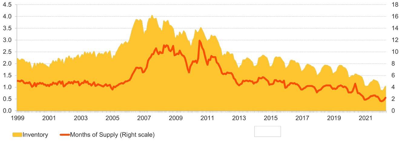
Figure #1. Graph showing National housing inventory and months of supply. Rep. The State of the Nation’s Housing. Cambridge, MA: the President and Fellows of Harvard College, 2022.
Figure 2: Annual Population + Housing Growth 2005 - 2016
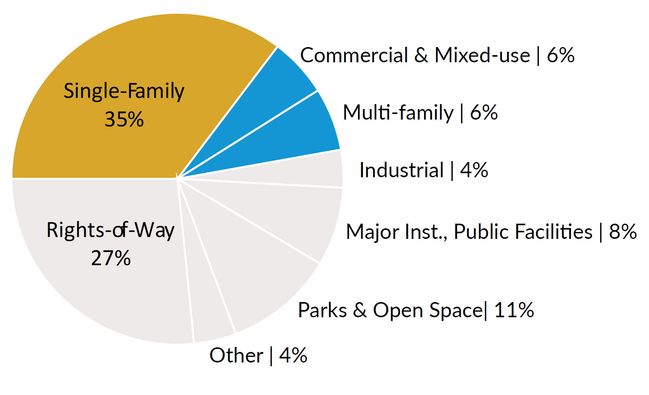
Figure #2. Graph showing Seattle’s annual new housing units lag behind annual population growth from 2005 - 2016. Seattle Planning Commission, “Neighborhoods for All: Expanding Housing Opportunity in Seattle’s Single-Family Zones, Fall 2018, 25.Figure 6: Distribution of Gross Acres by Land Use, City of Seattle 2018
-
According to Seattle’s Office of Planning & Community Development (OPCD), Seattle is currently experiencing a severe housing shortage (One Seattle Comprehensive Plan, 2021). This is a complex issue and can be attributed to many different factors. For the sake of this paper, the examination will focus on housing density as a means to increase supply. Due to Seattle’s restrictive zoning policies which only allow multi-family housing density in about one-third of residentially zoned land, affordability has become a huge issue (See Figure #4 and #5). To understand Seattle’s housing crisis, this section will follow the structure of a six-part analysis of the harms of its anti-density policies:
1. Affordability
2. Racial and economic inequities
3. Environmental impacts
4. Economic impacts
5. Limits housing choices and diversity
6. Contributes to homelessness
One of the major problems Seattle has been dealing with is that both the ownership market and the rental market of housing supply are not keeping up with demand (See Figure #2). Although the rate of housing construction has increased in the last few years, Seattle’s production of new jobs has triggered an increase in its population. “Between 2005 and 2019, Seattle would have needed to produce an additional 9,000 housing units to maintain its baseline ratio of jobs to housing units” (Ramsey et. al., 2021). Additionally, the Puget Sound Regional Council projects that the region will need an additional 810,000 housing units to accommodate the growing population in the next 20 years (Regional Housing Strategy, 2022). This unbalanced relationship creates competition and drives up costs. In the last decade, “Seattle’s median home values have increased by 80% compared to only a 55% increase in the country median family income” (Ibid).
The lack of housing supply due to regulations that limit density throughout the entire city have also contributed to the exclusion of both low-income communities and communities of color. First, the lack of affordability has contributed to the growing homelessness crisis and exacerbated the city’s social and economic challenges. Unlike people who are displaced by natural disasters and who are typically seen as victims, people who are forced into homelessness due to a lack of housing affordability are typically blamed for their hardships. Lower-income households, younger households, and Black households are disproportionately affected by the housing affordability crisis as well. About 62 percent of Black residents have reported being housing cost-burdened, compared to about 30 percent of white residents (See Figure #8) (King County Department of Community and Human Services, The Regional Affordable Housing Dashboard, 2019). This leads to housing landscapes which detached single-family dwellings are dominated by white residents, contributing to contemporary segregation (See Figure #7). As prices of housing continue to rise, many middle and low income households are being displaced and forced to move away from the city.
According to the Puget Sound Regional Council, one in three residents live and work in different counties, which means that many of the region’s residents commute long distances to get to work (Ibid). This has both negative individual health and environmental implications. Longer commutes contribute to increased air pollution and greenhouse gas emissions (Kazis, 2020). Anti-density policies can also lead to higher rates of energy usage. The detached single-family typology is exposed to a higher degree of exterior walls which increases its heating and cooling loads. Water quality can also become an issue in low-density development. The sprawl required to develop detached single-family neighborhoods require increased paving, which has negative effects on pollutants carried by stormwater runoff and has implications on natural habitats (Ibid). Additionally, the average size of newly constructed detached houses have been growing in size, which has intensified the environmental issues (Seattle Planning Commission Neighborhoods For All, 2018).
Regulations favoring low-density development in Seattle can have implications on the local economy as well. Following concepts of mixed-use urban development and city vitality discussed by Jane Jacobs in her book “The Death and Life of Great American Cities,” the integration of different building types and uses promotes successful and more productive cities (Jacobs, 1961). By reserving the majority of its residential land for the detached housing typology, the city has created distance from residential and commercial uses. As a result, commercial spaces in certain areas have seen high levels of vacancy rates due to a lack of foot traffic and potential customers (Baragona, 2022). Lack of density and mixed-use development has made it challenging for small businesses to thrive, as they often rely on nearby residents to function. This argument is often made by advocating for a 15-minute city: a place where residents can access all their daily needs within a 15-minute walk or bike ride from their homes. Exacerbated by the COVID-19 pandemic, the result of current policy is that many neighborhoods in Seattle lack the vibrancy and economic activity that comes with mixed-use development which can be detrimental to both local cultures, and the wider economy.
Lastly, Seattle’s anti-density policies artificially limit the creation of diverse housing options to accommodate different living arrangements, including different stages of life. This issue is often referred to as missing middle housing (See Figure #9 illustrating missing middle housing). Due to the restriction on housing density in the majority of the city, Seattle is prohibited from building housing types like duplexes, fourplexes, cottages, and small apartment buildings in single-family zones. Although non-conforming housing structures which fall into the missing middle typology exist as artifacts from previous—more flexible—zoning codes, Seattle’s current regulations forbid the new construction of these types of units. Seattle’s current housing supply mainly occupies two typologies: expensive detached single-family structures in low-density neighborhoods, and very dense apartment buildings along urban hubs and corridors (Seattle Planning Commission “Neighborhoods For All,” 2018). This is particularly difficult for older households who want to remain in their communities, but can no longer live in multi-story units or keep up with the maintenance of large properties. This can lead to social isolation, reduced access to services and amenities, and a decreased quality of life.
-
While zoning reform is one approach to addressing Seattle’s housing crisis, it is important to note that it is not sufficient on its own. There are many limitations to what zoning reform can achieve. Zoning reform may allow for increased density and flexibility in land use, but it does not necessarily address the underlying economic factors that drive housing affordability issues such as housing commodofication, income inequality, and the high cost of construction. Although zoning reform is necessary for the effort to address Seattle’s housing crisis, it must be part of a broader strategy to address issues of equity.
To fully understand the limitations of relying solely on zoning reform to address Seattle’s housing crisis, it is necessary to examine the history of zoning policies in the city. Zoning has played a significant role in shaping the development of Seattle, determining where and how different land uses and building types are allowed, and contributing to current housing affordability and supply challenges. The city has a long-standing tradition of downzoning its neighborhoods in an attempt to preserve the character of single-family communities, despite the growing demand for housing (Morales, 2017). Understanding the origins and evolution of Seattle’s zoning policies can provide valuable insights into the current state of housing in the city and inform future strategies for addressing these issues.
Figure #6. “Land use” refers to how land is currently being used, while “zoning describes the range of uses that are allowed. If all of Seattle’s land is considered, including rights-of-way, parks, and industrial lands, over a third is in use as single-family parcels. Only 6% is multifamily (lowrise, midrise, highrise) and 6% is commercial or mixed-use. Seattle Planning Commission, “Neighborhoods for All: Expanding Housing Opportunity in Seattle’s Single-Family Zones.” City of Seattle, 2018Figure 4 & 5: Distribution of Residential Zones City of Seattle, 2018
Neighborhood Residential Zoning (Single-Family)
Multifamily
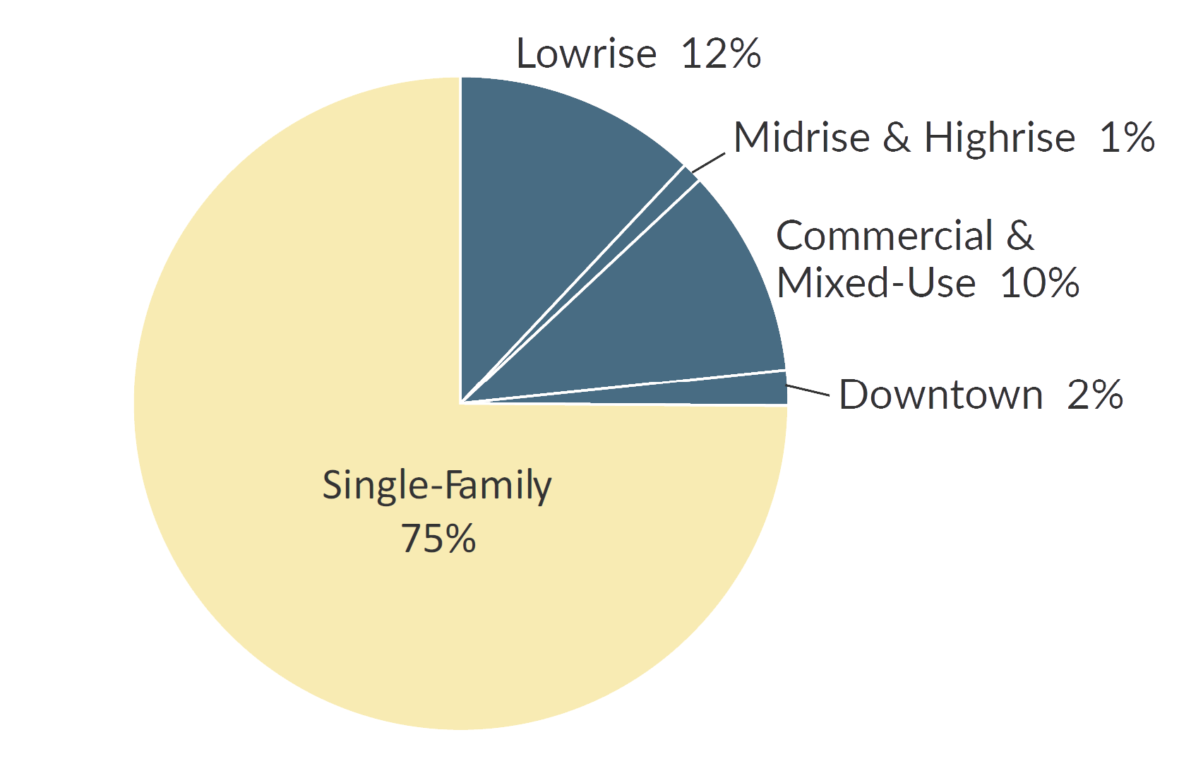
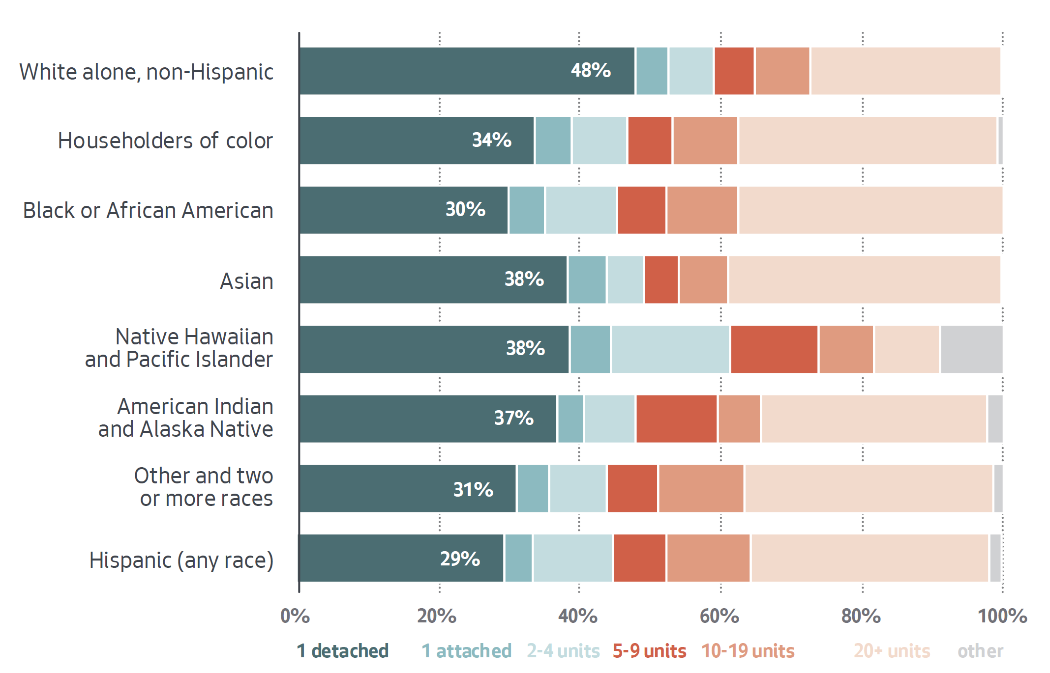
Figure 7: Race/Ethnicity of Householder per Housing Density, City of Seattle 2018
Figure #7. The type of housing a household occupies varies by race. Almost half of white non-Hispanic households live in detached one-unit structures. City of Seattle, “Accessory Dwelling Units: Final Environmental Impact Statement.” City of Seattle, 2018.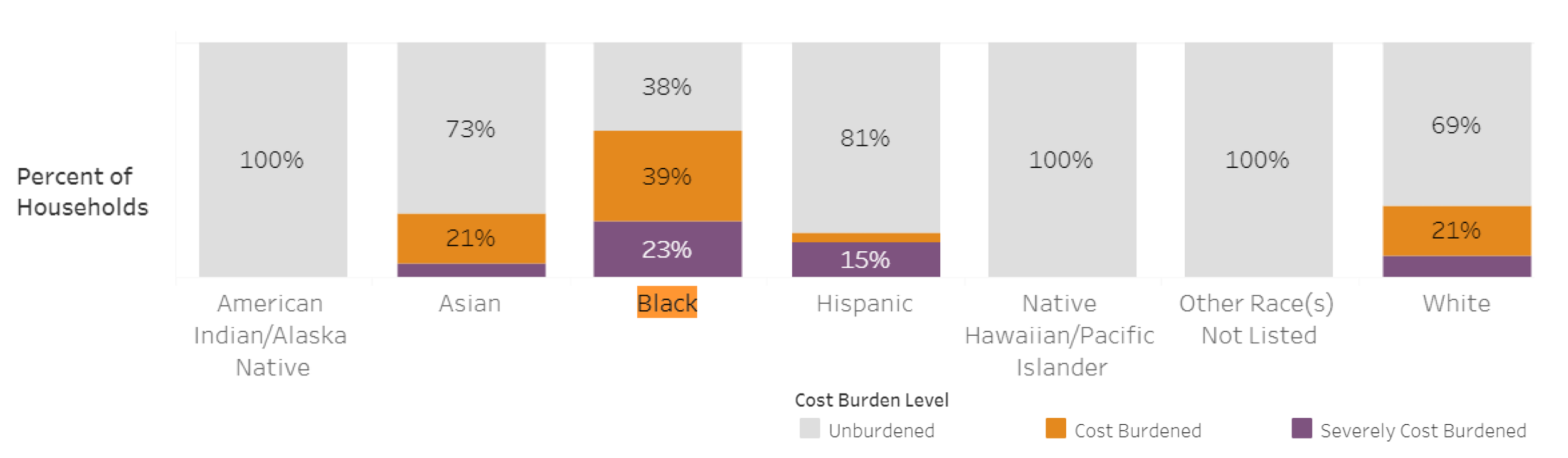
Figure 8: Housing Cost Burdened by Race/Ethnicity King County, CHAS 2015-2019
Figure #8. About 62 percent of Black residents have reported being housing cost-burdened, compared to about 30 percent of white residents. King County Department of Community and Human Services. The Regional Affordable Housing Dashboard, 2019.Figure 9: Middle Housing Typologies
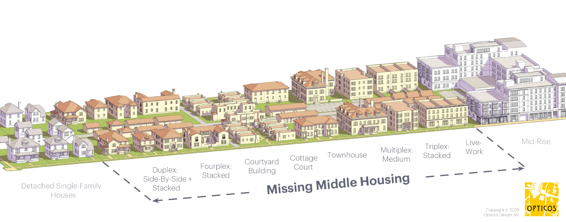
Figure #9. Missing middle housing is a range of house-scale buildings with multiple dwelling units. This includes Duplexes, Triplexes, Fourplexes, Courtyard buildings, Cottage court buildings, Townhouses, Multiplexes, and Live-work units. Parolek, Daniel G. Missing Middle Housing: Thinking Big and Building Small to Respond to Today’s Housing Crisis. Amsterdam: Island Press, 2020.2 Analysis
Seattle’s Land-Use History
Zoning is a critical component of urban planning, functioning as a tool to regulate the built environment and has been referred to as a tool for social control. At a basic level, zoning refers to municipal laws or regulations that govern how property can be used. Zoning typically defines and dictates a piece of land’s permissible use, density, and form of development through the enforcement of a zoning ordinance. Zoning ordinances typically state regulations in written text with an accompanying map that divides a municipality into zones. The fundamental goal of zoning is to manage the physical and environmental development of communities. Without it, many fear that uncontrolled growth would lead to incompatibility of new development with existing buildings and uses, loss of community character due to unregulated form and size of buildings, and ultimately lower property value. Simultaneously, scholars have demonstrated that excessive land restrictions can “1) make housing less affordable, 2) make the economy less productive, 3) exacerbate income and racial inequalities, 4) impose increased environmental harms, and 5) limit the types of housing available for different living arrangements, including at different stages of life.” Incompatibility of uses, however, was a very pertinent issue in the early 20th century, as urban centers were responding to industrialization, the growth of cities, and wider access to the automobile. Early zoning codes across the United States sought to address a variety of different issues including race, public health, safety, and perceived welfare of the community. Zoning quickly spread throughout the United States. Over time, zoning has evolved to encompass a wide range of uses and regulations including height and density restrictions, environmental protections, the promotion of affordable housing, protection of historic districts, and much more. Despite its evolution, zoning remains a foundation of land use planning, as it—somewhat silently— seeks to shape the built environment and influence the lives of urban residents.
With growing urban populations, some say that outdated zoning ordinances may now be artificially limiting the housing supply, affecting housing availability and affordability within urban settings. Despite the COVID-19 pandemic, cities across the globe have seen a boom in population, with the current 55% of the world’s population living in urban settings expected to rise to 80% by 2050. However, upzoning historically low-density neighborhoods in urban settings has proved to be a contentious issue, with many residents opposing upzones.
In light of the recent debate over upzoning as means of expanding housing opportunities, this paper will briefly examine the origins of zoning in the United States and explore the history of zoning in Seattle since 1919. Then, it will discuss the relationships between zoning policy and redlining, racial covenants, and deed restrictions, to understand the link between equity and different forms of land use regulations to demonstrate the urgency of this issue. This paper will end with discussing how the City of Seattle is addressing the consequences of inequitable policies, and how it plans to address them with the upcoming comprehensive plan update.
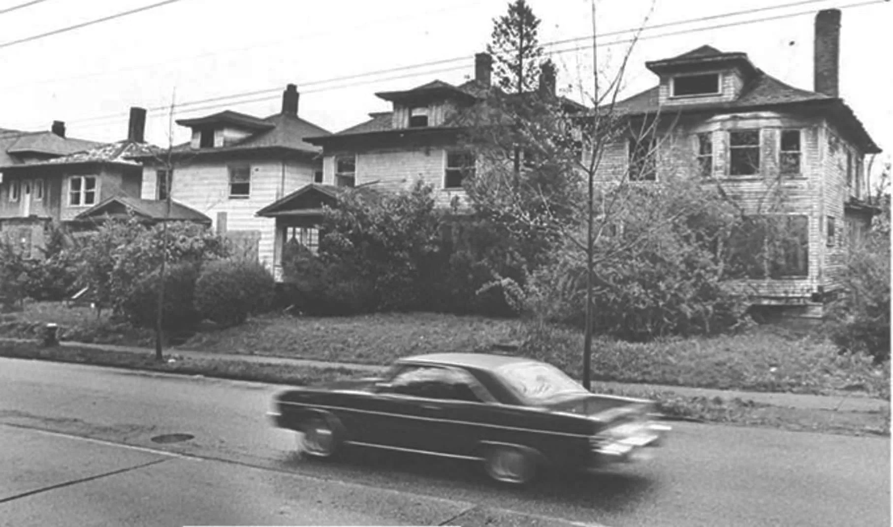
Figure #10. Holmberg, John. “Car passing cacant houses on Capitol Hill.” Digital image. Mohai Museumof History & Industry, April 13 1982. Accessed June 8, 2023. https://digitalcollections.lib.washington.edu/digital/collection/imlsmohai/id/10009/rec/1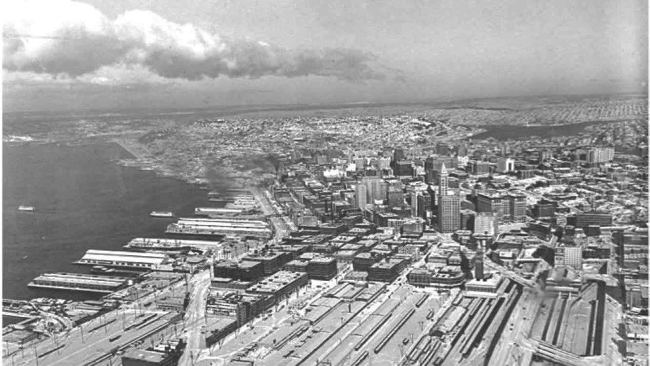
Figure #11. “Seattle, looking north.” Digital Image. University of Washington Libraries, Special Collections, [Order Number SEA1379, Negative Number UW2144], Between 1920 and 1950. Accessed June 8, 2023. https://digitalcollections.lib.washington.edu/digital/collection/seattle/id/555/rec/2Zoning in the United States
The origin of zoning in the United States was prompted by two main issues: the relationship between industrialization and health, as well as the demand for regulating racial and economic diversity in white neighborhoods (Rothstein 2017). One of the earliest zoning ordinances was passed in Baltimore in 1910, enforcing racial segregation, by maintaining separation between white and minority neighborhoods (Schindler, 2015). The Baltimore ordinance served as a model for exclusionary regulations in many Southern cities. Atlanta enacted a racial zoning ordinance three years later in which “its mayor stated that ‘[B]lacks should be quarantined in isolated slums in order to reduce the incidents of civil disturbance, to prevent the spread of communicable disease into the nearby white neighborhoods, and to protect property values among the white majority’” (Schindler, 2015). By 1917, the U.S. Supreme Court rejected the constitutionality of racial zoning, noting that it violated the due process clause of the 14th amendment, in Buchanan v. Warley (1917). However, this precedent did not entirely stop regulatory discrimination, and many Southern cities continued enacting and enforcing racial zoning ordinances through 1950 (Wittemore, 2021). Additionally, cities began to develop alternative ways to maintain racial and economic segregation in cities. The impetus behind the creation of many exclusionary policies restricting property focused around maintaining property values and neighborhood stability (Gotham, 2000). In an effort to exclude minority and low-income families, land-use policies began to regulate property value by controlling minimum lot size requirements, maximum density, height restrictions, and more (Wittemore, 2021). This has now been coined as exclusionary zoning. Scholars note that “in its most traditional incarnation, exclusionary zoning involves seeking to exclude poor and minority residents by adopting measures designed to drive up land prices. Traditional land use barriers restricting supply include, for example, large minimum lot sizes, off-street parking requirements, density limits, and prohibitions on multi-family housings” (Serkin, 2020). By decreasing affordability through form, those not part of the wealthy elite are subsequently excluded from regulated areas.
New York City is a good example form-based regulation which achieved industrial, racial, and economic separation in land-use. New York City had been experiencing problems related to the loss of light and air, as well as industrial uses encroaching along prominent retail districts since the late 19th century (New York City Planning History, 2023). Rapid urbanization and severe congestion were believed to have caused major disease outbreaks in the city. In response, NYC enacted its first comprehensive zoning ordinance in 1916, separating land uses into three categories: residential, commercial, and unrestricted (otherwise understood as industrial), as well as establishing height and setback requirements for buildings (Silver, 2016). “Zoning advocates early on noted how height and bulk restrictions could effectively shut immigrant-packed tenements out of single-family districts, whether in New York City or suburban Boston” (Wittemore, 2021). This is often incorrectly regarded as the nation’s first zoning ordinance in an American city. As a leading American city, NYC’s zoning ordinance set the stage for widespread zoning adoption across the country.
It is important to understand that although NYC’s 1916 comprehensive zoning ordinance did not explicitly address race and class in its language, the context and environment at that time was still deeply racist and prejudice against immigrant communities. It was the era of segregation, the Great Migration, and the Great Wave of Immigration, and these regulations were not being developed in a vacuum. Although NYC’s zoning did not directly govern neighborhoods by race like other American cities had, it still achieved social segregation through sorting regulating land use, building height, bulk, and density in an attempt to protect property values for wealthy landowners (Ingram, 2018). One of the goals of zoning advocates was to protect and cater to the wealthy elite of NYC which feared that the proximity to manufacturing lofts and the immigrant workforce might affect the value of their properties (Ingram, 2018). Besides explicit forms of land-use discrimination like redlining and racially restrictive covenants, it was common for cities to use more covert language restricting properties development rights to maintain property values through zoning, while still under the umbrella of exclusionary practices.
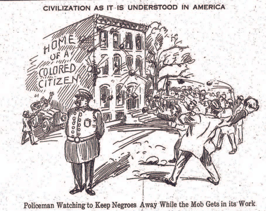
Figure #12. A comic from the 1913 Afro-American newspaper showing a group of white Americans in Baltimore throwing stones at a rowhouse labeled “Home of a Colored citizen” while a police offer stands by ignoring the crowd. This shows attitudes towards Black Americans and their neighborhoods at the time. Heritage, Baltimore. “1885-1929: Segregation and the Fourteenth Amendment.” Baltimore’s Civil Rights Heritage. Baltimore Heritage Club, 2022. https://baltimoreheritage.github.io/civil-rights-heritage/1885-1929/.
Figure #13. New York City 1916 Zoning Ordinance prescribing street wall height and sky exposure plan to allow daylight into the street and buildings. Source: Lighting Design and Application: LD and A. 16(6), Bryan, H. & Stuebing, S., Natural light as an urban amenity, 44-48, copyright 1986.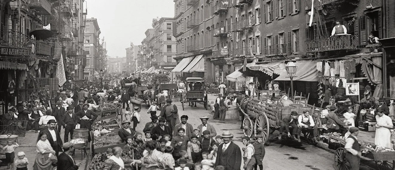
Figure #14. High density living in tenement housing in New York City. Source: Detroit Publishing Co. Mulberry Street, New York City. Photograph. Library of Congress, Photochrom prints. ca. 1900. https://www.loc.gov/item/2016794146/History of Land-use in Seattle: A Focus on Zoning
It is evident that exclusionary land-use practices do not necessarily require explicit racist language to assure the segregation of a city. Much like New York, Seattle’s history of land-use and zoning refrained from using racial language but achieved outcomes similar to cities which had explicitly outlined racially discriminatory zoning. Seattle’s early zoning codes relied heavily on fire prevention but evolved into form-based regulations which helped ensure that property values remained high, which effectively excluded low-income and minority communities from most of its residential landscape. Understanding Seattle’s zoning history is crucial for developing future growth proposals that aim to promote equitable policies. The city’s past demonstrates how policies, even when not explicitly discriminatory, can perpetuate segregation and inequity. Examining how zoning laws have been used to create and preserve segregation can help designers and policymakers identify the underlying causes of economic and social disparities and develop strategies to address them.
1917 Building Districts Map City of Seattle
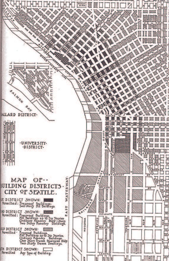
Figure #17. Seattle 1917 Building Districts Map. The Building Ordinances of the City of Seattle, the City of Seattle. The Seattle Municipal Archives. § (1917). http://clerk.seattle.gov/~F_archives/documents/Doc_18.pdf.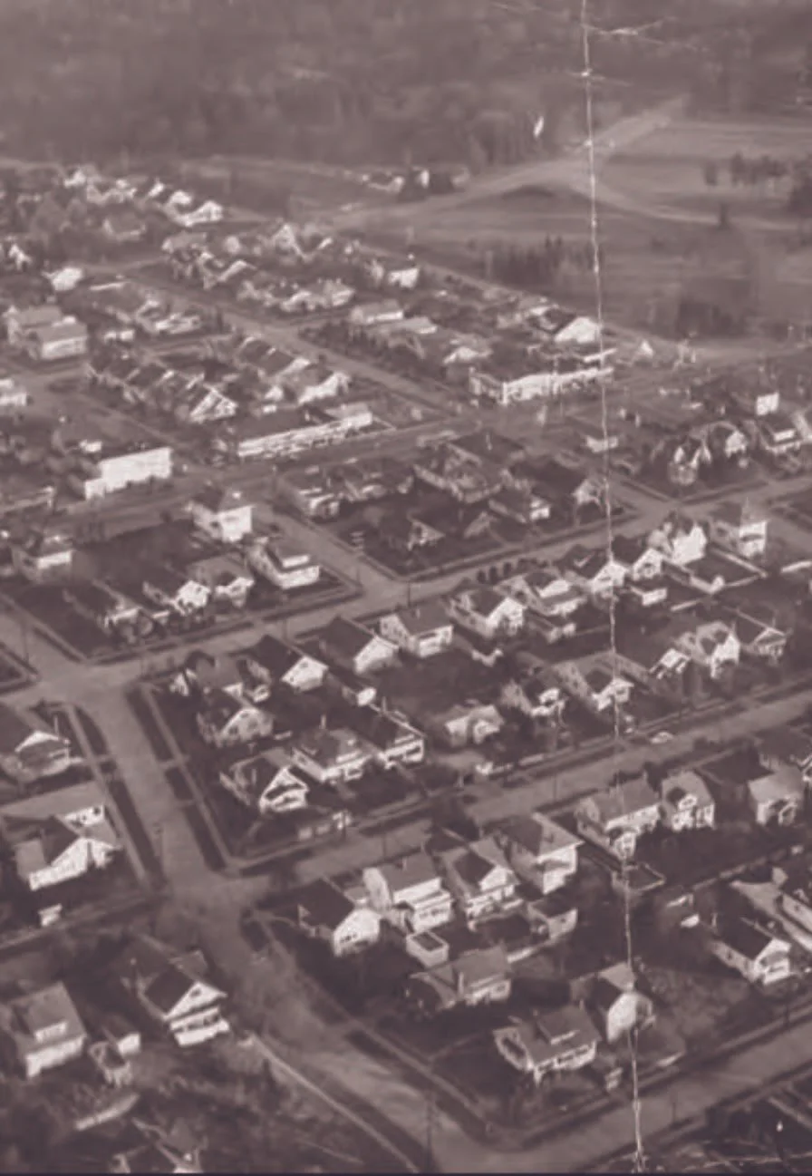
Figure #15. Residential development in Seattle in 1947. Source: Harris, Kenneth. Aerial view of houses in Seattle, Washington, December 1947. Photograph. University of Washington Libraries, Special Collections. 1947. https://digitalcollections.lib.washington.edu/digital/collection/seattle/id/5596/rec/100Seattle Pre-1920
In comparison to many other cities in the United States, Seattle is fairly young. Originally home to the Duwamish people, amongst other indigenous tribes, the city was officially founded by early settler-colonists in 1851 (Sale, 2019). Seattle’s location and resources demonstrated its potential to become a prosperous city, despite slow growth during its first three decades. Its proximity to the Puget Sound harbor made Seattle an ideal location for shipping, and the city’s abundant timber resources combined with a growing population helped it develop into a major economic center focused on logging, milling, and fishing (Findlay, 2015). Early land use regulations were written as building ordinances, revised every couple of years (Ochsner, 2002). These ordinances included passing early municipal taxes, regulations on liquor sales, regulations on nuisances, and to prevent fires (Prosch, 1901). In 1865, the city passed Ordinance No. 5 which barred indigenous people from residing in Seattle. In 1909 the first building ordinances were published, and compiled together as a city-wide building code, which was then updated every two to five years (Seattle Municipal Archives, 2023). This early building-code document regulated things like construction materials, fire prevention strategies, height limits, and a very early rendition of building districts (The Building Ordinances of the City of Seattle, 1909). These districts specified what types of materials could be used to construct buildings in certain areas. Closer to the city’s downtown core, fireproofing standards were more stringent, while areas farther away from downtown had more lenient requirements. These early regulations echoed the fear that the city had following the years of the Great Fire (1889).
The city updated the building code in 1917, changing the building district boundaries, and added regulations such as allowable lot coverage, yard variances, and setbacks (The Building Code of the City of Seattle, 1917). Despite these early district designations based on fire safety, the city did not have any formal zoning regulations in place (Seattle Municipal Archives, 2023). Locations of industry, for the most part, had been heavily influenced by modes of transportation. In Seattle, this meant that the majority of its industry was conducted along its waterfronts (Carlson, 1950). This was dictated by the technology available at the time and meant that other uses were naturally able to distance themselves from industry. The 1917 building code, thus, had no restrictions on where different types of homes (apartments, detached single-family residences, hotels, dormitories), and commercial space could be located (Eliason, 2018). This is why we often see non-conforming (duplex, triplex, and apartment) residential structures in single-family zones today. However, as the city continued to grow, and the rise of the automobile detached the reliance of industrial transportation from the waterfront and the railroad, industrial uses starting having the ability to appear closer to previously residential and commercial areas. As many other cities across the United States began adopted zoning codes, Seattle’s new mix of uses, and lack of regulations on where things could be built triggered the beginning of regulatory change.
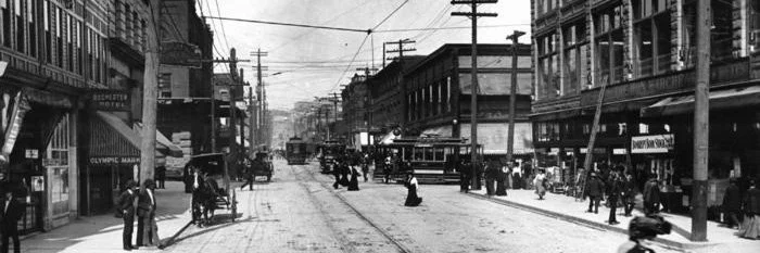
Figure #18. Downtown Seattle in 1911. “First Avenue, Street Scenes: Pike Street from First Avenue. The Seattle Municipal Archives. 1911.-
1909
The first Building Ordinance in Seattle is published.
The city is divided into “districts” to specify construction type, but not uses.
-
1920
Racially Restrictive Covenants
Residential areas begin establishing racially discriminatory covenants to exclude people of color and other groups.
The Supreme Court validates these in 1926, increasing their use.
-
1923
First Zoning Ordinance
Seattle establishes two residential zones: one for detached homes and one allowing apartments and other housing types.
No minimum lot size required.
-
1934
Redlining Established
The Federal Housing Authority introduces redlining, denying mortgages in neighborhoods with predominantly non-white residents.
This reinforces racial segregation and depresses property values.
-
1957
New Zoning Ordinance
Introduces single-family, duplex, and multifamily zones with stricter development standards.
Imposes a 5,000 sq ft minimum lot size and downzones many duplex areas.
-
1960s–1970s
Downzoning Continues
Land use changes reduce multifamily and duplex zoning, expanding exclusionary single-family areas.
-
1994
ADUs & Urban Villages
Accessory dwelling units (ADUs) are legalized.
The Urban Village Strategy concentrates growth into designated areas.
-
2009
ADUs Expanded
Detached ADUs are allowed on lots over 4,000 sq ft, though regulations limit feasibility.
-
2011
Lowrise Zoning
Duplex zones are replaced with lowrise zoning, allowing townhouses and apartments and shifting to floor area ratio controls.
-
2018
MHA Established
Mandatory Housing Affordability (MHA) increases density in some areas in exchange for contributions to affordable housing.
Raises concerns about displacement.
-
2023
HB 1110 Passed
Washington requires “middle housing” in residential zones, allowing duplexes to sixplexes.
Minimum 4 units per lot, or 6 near transit/with affordability, with reduced parking mandates and streamlined approvals.
-
2024
Comprehensive Plan Update
King County adopts its 10-year update aligning with new laws, expanding housing strategies, addressing past inequities, and advancing climate goals.
Seattle 1920-1923
Discussion of Seattle’s first zoning ordinance began in 1919. By 1920, Seattle passed Ordinance 40407 which established the Seattle Zoning Commission (Seattle Municipal Archives, 2023). The ordinance sought to “make a survey of the City of Seattle with a view of dividing [it] into zones or districts, and report to the City Council a zoning or districting ordinance which shall specify the uses to which property in each district may be devoted . . . for the promotion of the public peace, health, convenience and welfare” (Seattle Ordinance No. 40407, 1920). This language can be compared to language used in Baltimore’s “Segregation Ordinance” in 1911, which also expressed the need to preserve the peace to prevent conflict in order to achieve racial segregation (Benson, 1915). Addressing issues of an increasing mix of uses and largely unregulated city, the Zoning Commission began “restricting the location of trades and industries; regulating and limiting the use of buildings and premises and the heights and size of buildings; providing for yards, courts or other open spaces; establishing districts for the said purposes; defining offenses; prescribing penalties and repealing all ordinances or parts of ordinances in conflict therewithin” (Seattle Ordinance No. 45382, 1923). Part of the motivation for the Seattle Zoning Commission was to begin to regulate housing density. This is seen on a flier promoting the Seattle Zoning Commission (Figure #19 which illustrates “eight cottages on one 60 ft lot” and asks “would you like this condition next to your home? Zoning would prevent it.” As the newly established Zoning Commission began to work on the new zoning policy, they consulted with Harlan Bartholomew, a then influential urban planner from St. Louis. Bartholomew assisted Seattle’s Zoning Commission with its work, creating a “Zoning Program for Seattle” where he advised the city to create a “residential use map,” dividing residential neighborhoods by density (Seattle Municipal Archives, Zoning Commission: A Zoning Program for Seattle prepared by Harland Bartholomew, 1921). Having made his mark as an urban planner, Bartholomew had been hired by many cities across the country to help develop zoning and comprehensive plans. “Bartholomew advocated for racial segregation to preserve neighborhood property values” (Benton, 2017). It is unclear the depth of Bartholomew’s involvement in creating Seattle’s first zoning ordinance. Evidence indicates Seattle’s early planners saw zoning as a tool to “preserve the more desirable residential neighborhoods” and prevent movement into “finer residential districts by colored people” (Rothstein, 2017).
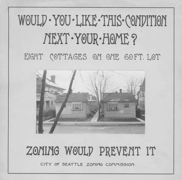
Figure #19. Poster promoting Seattle’s original 1923 zoning ordinance and its introduction of “single-family” zoning. City of Seattle. Mohler, Rick. “A Reckoning With Single-Family Zoning’s Impact on Racial Equity—and on Architects’ Livelihood.” Architect Magazine, 2020. https://www.architectmagazine.com/practice/rick-mohler-a-reckoning-with-single-family-zonings-impact-on-racial-equityand-on-architects-livelihood_o.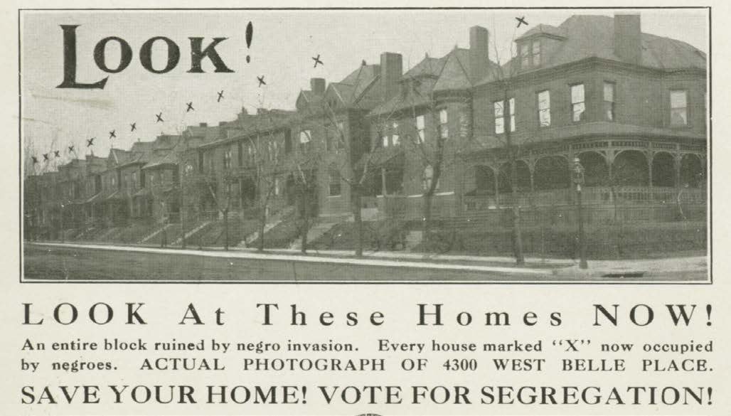
Figure #20. 1916 leaflet proposes to segregate St. Louis. This measure was developed in collaboration with Harland Bartholomew. https://www.unz.com/wp-content/uploads/2015/02/ScreenShot2015-02-17at6.53.16PM-1.pngIn 1923, after many public meetings, the proposed zoning ordinance was finalized by city staff, was presented to City Council, and became a law (Seattle Municipal Archives, 2023). The new zoning ordinance included a written document explaining regulations, as well as many zoning maps which illustrated Seattle’s new zones. At this point, virtually all of Seattle was subdivided—regardless of whether it had been developed or not. The majority of Seattle’s street pattern had existed prior to the passing of the 1923 zoning ordinance which effectively codified it. These papers were available for the public to access, as a standard for future development. Previously, building code regulations in Seattle had been centered around fire-prevention strategies. With a growing city that had concerns related to industry and urbanization, the new zoning ordinance addressed new issues associated with building use and size. The new ordinance abandoned the previously established districts based on fire-safety level, and instead organized zones based on six use districts: first residence (primarily SF), second residence (SF and MF), business, commercial, manufacturing, and industrial (Seattle Ordinance No. 45382, 1923). Additionally, the new ordinance also established building height maximums, lot coverage maximums, and setbacks based on the new district areas. The new code essentially analyzed existing land-use patterns in Seattle and ratified what had historically existed. This was the first time that the city of Seattle began to see regulations on preserving and promoting the concept of the single-family neighborhood. Previously, a mixture of residential density development was allowed to coexist throughout the city; detached single-family homes had been allowed to exist alongside multi-family buildings. Although the separation of density through zoning may have been due to Bartholomew’s influence of racial prejudice, nearly all whites at that time shared the belief that cities had to restrict the growth of minority populations to preserve the city’s white neighborhoods (or “public safety and order”). Some argue that the preservation of detached single-family structures was a response to the increasing demand for this housing typology, and was meant to provide residents with more privacy and space, based on contemporary planning theories which emphasized the importance of separating land uses. Regardless of the motivations behind the ordinance, research conducted by scholars have found that areas which had greater Black or Chinese American populations in Seattle were disproportionately likely to receive commercial zoning, and thus were isolated in undesirable neighborhoods. (Rouse et al., 2021).
1923 Zoning Map City of Seattle
Figure #21. Seattle’s 1923 Zoning Map Key. Source: City Zoning Commission. Key Map [graphical index to zoning maps]. Seattle Municipal Archives Digital Collections. 1923. http://archives.seattle.gov/digital-collections/index.php/Detail/objects/208101923 Zoning Map, Plate 9, City of Seattle
Figure #22. Seattle’s 1923 Zoning Use Map for plate 9. Source: City Zoning Commission. Plate 9 / use map [1923 zoning]. Seattle Municipal Archives Digital Collections. 1923. http://archives.seattle.gov/digital-collections/index.php/Detail/objects/20828It is important to note that there was no explicit language within public policy which excluded people of color from living in certain areas in Seattle’s at this point. Racial restrictions exclusively existed within private agreements. At this time, Seattle’s Black population was growing quickly. Seattle’s 400 Black residents in 1900 grew to about 2,300 in 1910; “African Americans found it impossible to rent or buy housing outside [the International District, Capitol Hill, and the Central District], and in many parts of the city they were not allowed in theaters, nightclubs, and restaurants” (Lesson Twenty-One, 2021). Additionally, those who held positions of power in the 1920 Zoning Commission directly benefited from other forms of exclusionary land-use practices. For example, Clarance B. Blethen, the permanent president and member of the commission lived in a home within a restricted subdivision which noted “property herein described shall not be sold, conveyed, leased or given to any person or persons other than that of the Caucasian race” (City of Seattle Zoning Commission Meeting Minutes, April 1920)
Seattle 1923-1957
After the Supreme Court found that segregation through city ordinances was illegal in Buchanan v. Warley (1917), the use of racially restrictive covenants emerged. Not only was this method of racial discrimination permissible, but it allowed cities to continue segregation without placing any blame on municipal leaders (Silva, 2023). Private agreements in the form of covenants that prohibited the sale, lease, or occupancy of a piece of land by individuals of a specific race gained popularity after Corrigan v. Buckley (1926), ruled that racially restrictive covenants were legal (Corrigan v. Buckley, 1926). Private covenants are often referred to as deed restrictions and are tied to the land. When a property was sold or transferred, the covenants were included in the deed and became a binding agreement between the property owners and the buyer. The implementation of racial restrictions in these private agreements helped perpetuate racial segregation and discrimination in housing around Seattle (Silva, 2023). Typically, land developers and real estate companies would write the racially restrictive covenants before the parcels were sold and developed (Silva, 2023). The government would not directly enforce private agreements, but violating the covenants usually resulted in legal actions from real estate boards and neighborhood associations. Discrimination from banks, insurance companies, and the federal government through the denial of financial services such as loans or insurance to minority communities also became a popular way to ensure segregation in the late 1930’s. This has become a topic of conversation amongst contemporary proposals for change, noting that private covenants may be a barrier and used as a tool to contest future proposals for increasing density.
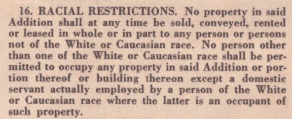
Figure #23. A racial restriction on the Blue Ridge neighborhood of Seattle, one of several neighborhoods developed by Bill and Bertha Boeing.. Silva, Catherine. “Racial Restrictive Covenants History.” The Seattle Civil Rights and Labor History Project. University of Washington, 2023.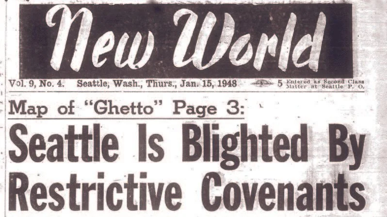
Figure #24. A New World Map Shows Seattle’s “Ghetto,” 1948. Silva, Catherine. “Racial Restrictive Covenants History.” The Seattle Civil Rights and Labor History Project. University of Washington, 2023.1947 Zoning Map City of Seattle
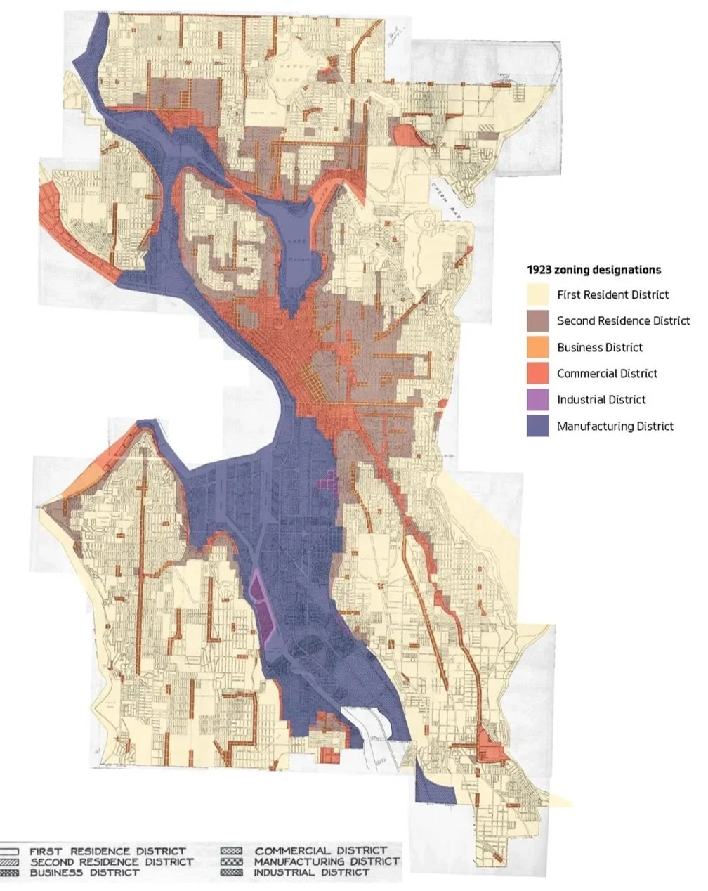
Figure #26. 1947 Zoning Map Key. Created by the Seattle Planning Commission. http://
archives.seattle.gov/digital-collections/index.php/Detail/objects/20879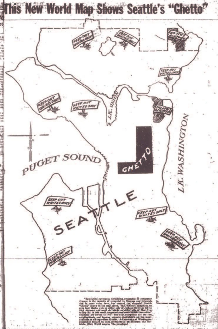
Figure #25. A New World Map Shows Seattle’s “Ghetto,” 1948. Silva, Catherine. “Racial Restrictive Covenants History.” The Seattle Civil Rights and Labor History Project. University of Washington, 2023.A year following the first zoning ordinance, the city of Seattle decided to replace the Zoning Commission with a City Planning Commission (1924) to adopt a more comprehensive and coordinated approach to urban planning that could go beyond the limited scope of zoning regulations (Seattle Planning Commission Annual Reports, 1928-2016). At this time, the federal government had organized an Advisory Committee on Zoning which developed the Standard State Zoning Enabling Act (SZEA), establishing a model for planning and zoning statues that could later be adopted by states (Standard State Zoning Enabling Act, 2022). This was developed by the Secretary of Commerce Herbert Hoover, as “a concerted effort by the federal government officials to effectively achieve racial segregation by circumventing Buchanan’s prohibition on explicit racial zoning ordinances through economic zoning measures” (Kim, 2021). The newly formed City Planning Commission had broader powers to consult the City Council on the physical development of the city, including transportation, public utilities, parks, and housing, civic improvements, in addition to zoning (Seattle Ordinance No. 59625, 1920).
By 1929, the Planning Commission grew to 25 members and consisted of “the city engineer, a Councilmember, and other officials and business leaders” (Seattle Municipal Archives, 2023). In 1930, there were concerns that Planning Commission was too large and influenced by special interests, leading to its reduction in size to just nine members (Seattle Municipal Archives, 2023). This refined group included “five community members, the City Engineer, Superintendent of Buildings, President of Park Board and a member of City Council” (Seattle Municipal Archives, 2023). During this time, the city began developing zoning maps which organized the city into section grids, otherwise known as plates, and established eight use districts and four area districts, among other regulations. The use districts included R1 (first residence), 2F (two family residence), R2 (second residence), B (business), C (commercial), 1M (first manufacturing), 2M (second manufacturing), and I (industrial). This furthered the separation of uses, by classifying levels of intensity. By 1947, the city had directed more funds towards the Planning Commission (Seattle Municipal Archives, 2023). A set of zoning maps were developed soon after the city hired its first director of planning. These new zoning maps further separated the 1923 residential zones; what used to be called the “second residence district” had now been split into two separate categories: “two family district” and the “second residence district.” The creation of the two-family district offered a middle ground between the city’s multi-family and single-family areas, thereby providing a way to gradually rezone large areas of Seattle’s multi-family zones. This meant that significant downzones occurred in the city during this time, taking areas which had previously allowed multi-family buildings and limiting them to a maximum of duplex-triplex buildings. As city planning became more complex, Seattle turned its attention to comprehensive planning. With plans to develop a coordinated approach to planning, the city hired a planner to lead the development of an all-encompassing plan for the city, which was eventually approved as the Comprehensive Plan in 1957 (Seattle Municipal Archives, 2023).
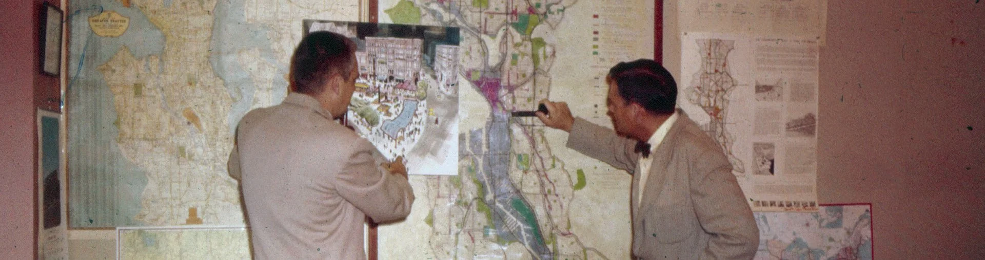
Figure #31. The Seattle Planning Commissioners creating Seattle’s first Comprehensive Plan of 1957. SOURCE: Seattle Municipal Archives, Researching Historic Land Use and Zoning (2023). City of Seattle.Seattle 1957-1980
From 1957 there is a distinction between Seattle’s zoning ordinance and the comprehensive plan. After 1957 these became two different planning tools serving different purposes in Seattle. The zoning ordinance strictly regulates land use and development in the city, whereas the comprehensive plan outlines broader goals for the city’s development. The idea was that the comprehensive plan would inform subsequent zoning ordinances, and thus, courts would only enforce the latter. The development of Seattle’s first comprehensive plan represented a shift from a narrow emphasis on zoning to a more general strategic framework to guide decision-making about future growth and development in the city. In 1957, Seattle’s Planning Commission adopted its first Comprehensive Plan which sought to enhance “present desirable qualities of Seattle, improve the environment for living and working, relate private and public facilities for maximum economy and service, and coordinate the development of the city with that of the metropolitan area and the Puget Sound region” (Comprehensive Plan Resolution No. 17488, 1957). According to the plan, it would serve as a basis for ordinances that guide the development of both public and private land, including zoning subdivision regulations, and the official street plan.
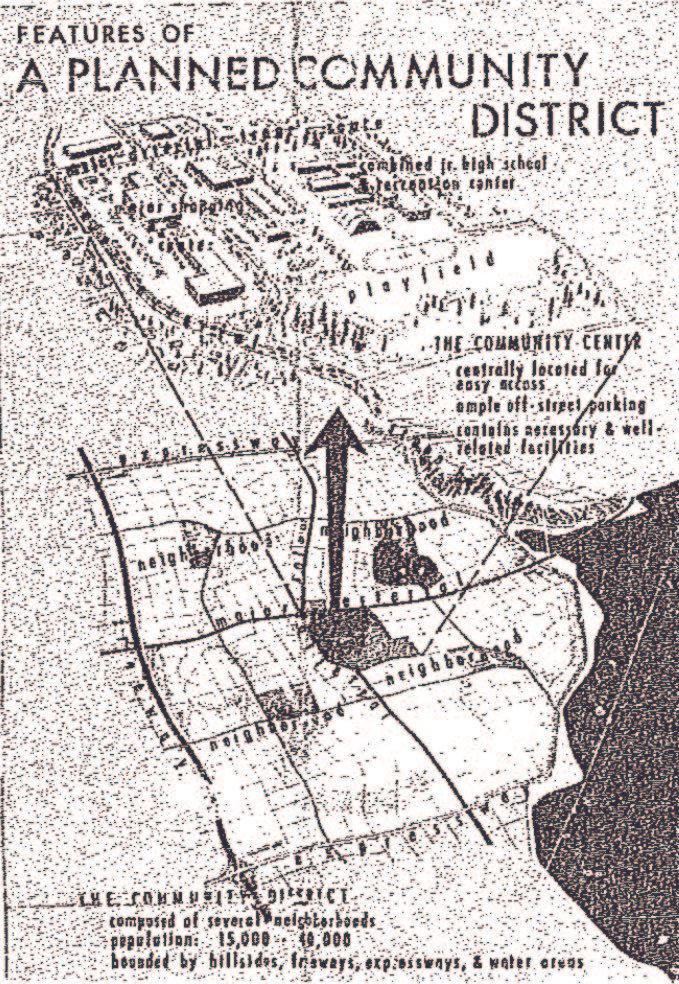
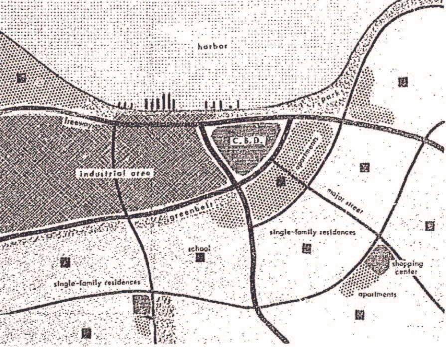
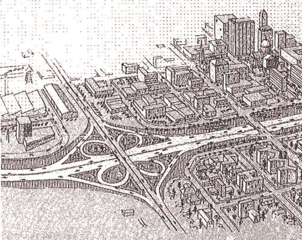
Figure #29-31. Community and Neighborhood Plan Illustration from Seattle’s 1957 Comprehensive Plan. http://clerk.seattle.gov/~archives/Resolutions/Resn_17488.pdfThe three main elements of the plan were, (1) the Land Use Plan, (2) the Arterial Thoroughfare Plan, and (3) the Community and Neighborhood Plan (Comprehensive Plan Resolution No. 17488, 1957). The Land Use Plan effectively advised future zoning codes by outlining suggested uses of both private and public land (Figure #29) (Comprehensive Plan Resolution No. 17488, 1957). The Arterial Thoroughfare plan outlined the location of “a network of freeways, expressways, and major streets, to accommodate future traffic volumes without congestion, (Figure #30). As suburban communities became more accessible, the city started to see many of its urban residents move to the surrounding suburbs (Boswell & McConaghy, 1996). The urban sprawl resulted in increased traffic congestion, and as the city dealt with issues of decentralization and urban decline, the Comprehensive Plan sought to address congestion through more effective urban arterial streets. Lastly, the Community and Neighborhood Plan provided organization of the residential areas of the city based on size and population. It effectively managed the location of public facilities such as schools, playgrounds, parks, and other amenities, (Figure #30). The plan manifested itself in the form of a singular map which outlined all three elements coordinated together, (Figure #32 and #33). In the map, the commission proposed seven areas, in which the zoning code could then outline associated regulations. These areas included low-density residential, high-density residential, major business centers, commercial areas, industrial areas, future industrial areas, and public or semi-public areas. Other elements of the plan included a guide for “future development of urban renewal studies aimed at preserving the quality of Seattle’s residential areas.” Similar to the 1947 plan, the 1957 plan also made reductions in the amount of land available for multi-family buildings. By this point, multi-family housing options (except for duplexes) were “outlawed in over half the city” (Eliason, 2018).
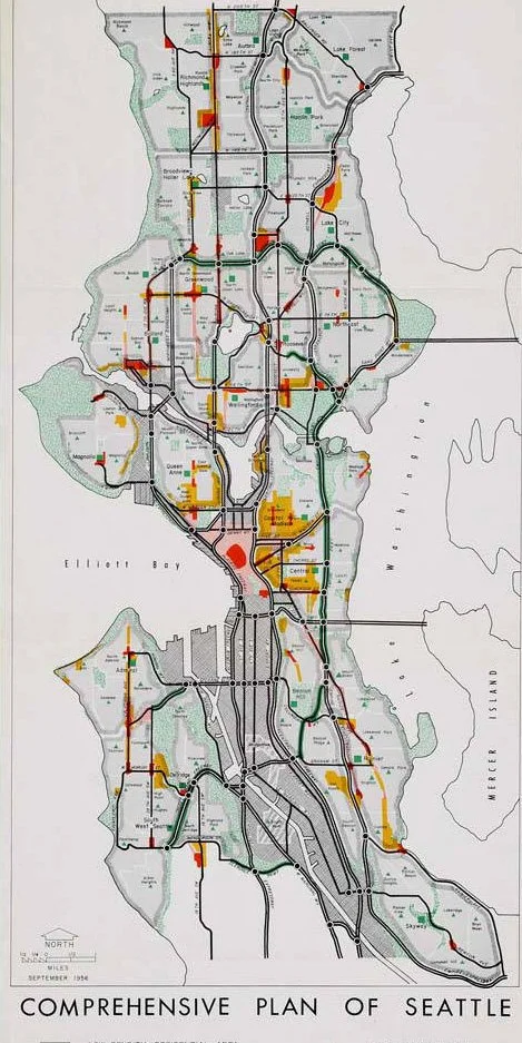
1956 Seattle Comprehensive Plan
Figure #32 (top) and #33 (bottom), Comprehensive Plan of Seattle. Source: Seattle City Planning Commission. Comprehensive Plan of Seattle, September 1956. Maps. Museum of History & Industry Collection. 1956. https://digitalcollections.lib.washington.edu/digital/collection/imlsmohai/id/13453/A year after the creation of the Comprehensive Plan in 1958, the city codified and published its ordinances as the Seattle Municipal Code (SMC), and Ordinance 86300, the Zoning Ordinance was placed in Title 26, the Zoning Code (Seattle Municipal Archives, 2023). The idea was that the zoning ordinance was to be updated based on the new comprehensive plan (Seattle City Planning Commission, 1956). Seattle experienced many changes in the years that followed. The city created the Department of Community Development (DCD) in 1969 and merged the Planning Commission into the new department. First addressing issues of city vibrancy and growth, and then tackling historic preservation, the city created an urban investment program titled Forward Thrust in 1968 (Mullins, 2022). The program undertook the task of urban reform in Seattle by investing in public works including the construction of the King Dome, various arterial highways, youth centers, recreation facilities, parks, fire stations, and sewer systems (Ochsner, 2023). However, not all proposals within this program moved forward including a proposed rapid transit system, county stormwater upgrades, and low-income housing proposals. As a response to growing urban renewal proposals including projects which would have demolished Pike Place Market, and parts of Pioneer Square, the city began delineating special districts in 1970. This included historic districts and landmark districts which helped protect historically relevant areas (Seattle’s Historic Districts, 2023). In the mist of the creation of historic districts, the city created the Office of Urban Conservation to help manage and administer these programs (Seattle Planning Commission Annual Reports, 1928-2016). Critics note that although the Forward Thrust program produced a large number of public projects benefiting the city, their position had a distinctly “middle-class (really, upper-middle-class) focus,” and failed to sponsor the creation of social programs or address urban poverty (Mullins, 2022). Like many publicly funded projects, Forward Thrust was aimed at handling predicted growth, rather than addressing existing issues of the underclass already residing in the region. Growth continued for a while, and both the zoning code (now part of the SMC) and the city’s Comprehensive Plan continued to receive updates until 1978 when the city began to rely on land use policies instead of issuing their own comprehensive plan (Seattle Municipal Archives, 2023). While departmental change was occurring within city organizations, its residents were dealing with the beginnings of a major housing crisis. Because of the Boeing Bust (1970) and a global oil crisis (1973), Seattle began to see an “overall downturn in investment and construction” in housing (Seattle Municipal Archives, 2023). Many of its multi-family rental units were being converted to condominiums; and because the majority of the city had been zoned exclusively for single family and duplex residential buildings, many residents were displaced and had nowhere to go. Tenants began to protest the lack of affordable housing in the city; however, they were met with pushback from homeowners, builders, and rental owners who were in favor of “free-market economics” (Seattle Municipal Archives, 2023). Seemingly reflecting issues we still see today, the Mayor’s office addressed the housing crisis in 1978 by stating that “Seattle is thought of as being a city of single-family houses, but the fact is, that nearly a third of our people are tenants in multi-family housing” (Mayor Charles Royer, 1978). By acknowledging that Seattle’s residential landscape had been dominated by single-family houses despite the need for denser and more affordable housing options, it appears that city leaders and policymakers were aware of the issues that zoning was having on housing supply.

Figure #35. Seattle Post-Intelligencer Article Title (published as SEATTLE Post-Intelligencer EXTRA) - July 22, 1973 - page 10.Seattle 1980-1994
The 1980s and 1990s brought significant change. As the city phased away from issuing its own comprehensive plan in the late 1970s, land use regulations continued to influence the adoption of new zoning policies, “including regulations that supported mixed-use development through the 1980s.” Dating back to the 1920s, many modernist planners had previously thought the separation of uses and creation of exclusive residential sectors would create successful cities. Under the influence of writers like Jane Jacobs and others, Seattle architects and planners began to challenge this. Seattle’s regulations began to partially turn away from the enforced separation of uses through the support of mixed-use development in new zones designated Neighborhood Commercial (NC), as well as through the development of a new Downtown Land Use and Transportation Plan.
However, despite the new interest in mixed-use development, new zoning policies refrained from encroaching on single-family neighborhoods with multi-family housing. Instead, the opposite occurred. In a research article by Sightline Institute, author Margaret Morales notes the consecutive downzoning of a Wallingford block, typical of its neighborhood, beginning from the 1923 zoning designation of multi-family to the 1960s zoning designation of residential duplex, to finally, the 1980s designation of single-family residential (Figures #36, #37, and #38) (Morales, 2017). The preservation and protection of single-family residential zoning remained a priority for policymakers through the 1980s. Figures #39 through #41 show the type of structures residual from a more flexible building code, no longer allowed due to downzones. The 1980s also brought major zoning changes to commercial zones, creating the designation of “the High Rise” (later Downtown) zone in the city through several ordinances. Under the authority of the City Council, the Planning Commission became an independent entity again, “no longer review[ing] site-specific land use applications and permits” (Seattle Planning Commission Annual Reports, 1928-2016).
1923 Zoning: Multi-Family
Figure #36. 1923 Zoning of a Wallingford Block. Image Courtesy of Seattle 1923 zoning map. plate 7. from Seattle Municipal Archives Map Index.1960 Zoning: Duplex Residential
Figure #37. 1960 Zoning of a Wallingford Block. Image Courtesy of Seattle 1960 zoning map. plate 22E. from Seattle Municipal Archives Map Index.1980 Zoning: Single-Family
Figure #38. 1980 Zoning of a Wallingford Block. Image Courtesy of Seattle 1980 zoning map. plate 22E. from Seattle Municipal Archives Map Index.Previously having been dominated economically by Boeing, Seattle began to see a resurgence in economic stability due to the growing technology industries beginning in the 1980s. Microsoft emerged as a leading tech company in Seattle after Bill Gates and Paul Allen moved its headquarters from New Mexico to Bellevue (a Seattle suburb) in 1979 (Paul Allen’s Life and Legacy, 2023). Other globally known companies such as Starbucks (1971), Nordstrom (1973), and Costco (1983) also contributed to the ongoing growth in the city. In 1994, Jeff Bezos founded Amazon from his garage in Bellevue, and later expanded to Seattle (Clifford, 2018). The region’s post-industrial success helped put Seattle on the map as a hub for technology and innovation and contributed to the city’s growth and wealth.
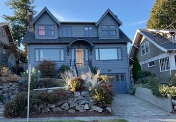
Figure #39. Duplex at 1927 25th Ave E (1928) in Current Single-Family Zone. by King County Assessor (public domain).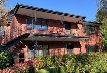
Figure #40 Triplex at 1436 E Ward St (1957) in Current Single-Family Zone. by King County Assessor (public domain).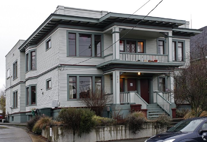
Figure #41. 5-Unit Residential Building at 943 24th Ave (1901) in Current Single-Family Zone. by King County Assessor (public domain).Seattle 1994 and later
The State of Washington passed its Growth Management Act (GMA) in 1990, which required the city to develop a new 10-year comprehensive plan. The GMA required all cities and counties in Washington to designate and protect wetlands and critical areas, designate agricultural, forest, and other natural resource lands, require evidence of potable water before issuing permits, and determine if new residential developments have appropriate provisions for public services and facilities (Growth Management Acts 1990, 1991). Their objective was essentially to provide set of guidelines for approximately 20 years of growth and development needs for a particular area. The GMA noted that the comprehensive plan needed to “protect forested areas and create density policies in urban areas based on neighborhood plans” (Seattle Municipal Archives, 2023). In 1994 Seattle established their new Comprehensive Plan and titled it “Toward a Sustainable Seattle” (City of Seattle Comprehensive Plan, 1994). The new plan established Seattle’s general goals for the city and organized itself into several elements including: land use, transportation, housing, capital facilities, utilities, economic development, and neighborhood planning. The most notable idea in the plan was the emphasis on an “urban village strategy” to accommodate the expected population growth of the city, while also preserving what they call “sustainable development.” The urban village strategy aimed to create self-sustaining, mixed-use communities that encourage walking, biking, and public transportation. At this time, policymakers were worried that the city infrastructure could not handle more traffic, so new zones were adopted to promote areas which could rely less on the automobile—transit and land-use were intended to work together. It focused concentrated density of housing and commercial development, or “growth centers,” in about 30 locations land throughout the city (Centering Racial Equity in the One Seattle Plan, 2022). Although the idea of tying density to public transit has value, today this approach to density is contested. The strategy has led to all new housing occurring in small pockets of the city, while the majority of residential zones have seen little growth. The city acknowledges that the strategy has led to patterns of segregation, artificial constraints on affordability and housing diversity, and fueled displacement by concentrating new housing in limited areas (Centering Racial Equity in the One Seattle Plan, 2022). The plan states that it “retains Seattle’s commitment to preserve the character of its many, diverse neighborhoods, [and] its strong single-family areas” (Centering Racial Equity in the One Seattle Plan, 2022). Arguments on protecting “neighborhood character” in this context may refer to “white” and “affluent” neighborhoods and must be questioned for their potential to perpetuate systemic inequalities and exclusionary practices. After the approval of the Comprehensive Plan, the city established a Neighborhood Planning Office which addressed issues and impacts of the urban village strategy on neighborhoods. Seattle has been developing a Comprehensive Plan ever seven to ten years ever since the re-implementation in 1994. (Seattle Municipal Archives, 2023). The city typically updates and amends their zoning ordinance to match the Comprehensive Plan soon after any updated plan is proposed.
1994: Seattle Comprehensive Plan
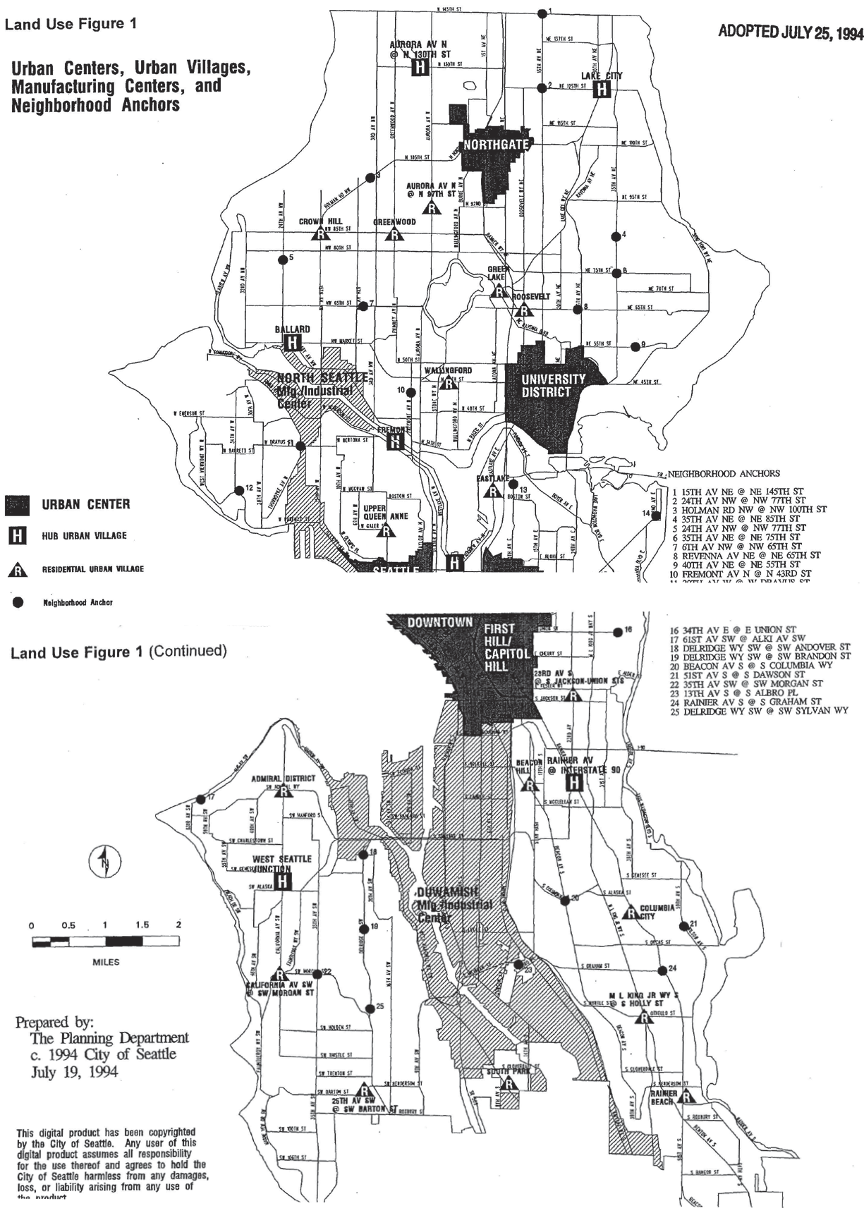
Figure #42. Seattle’s 1994 Comprehensive Plan. Urban Centers, Urban Villages, Manufacturing Centers, and Neighborhood Anchors Map. Source: “The City of Seattle Comprehensive Plan: Toward a Sustainable Seattle.” (Seattle City Council, 1994).2015: Seattle Comprehensive Plan
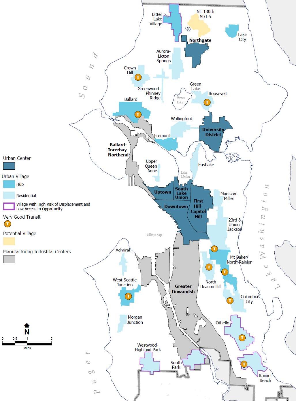
Figure #43. Seattle’s 2015 Comprehensive Plan, “Seattle 2035,” Not much has changed since the 1994 plan in relation to growth centers. Source: “The City of Seattle Comprehensive Plan: Seattle 2035.” (Seattle Office of Planning and Community Development, 2015).2017: Seattle Neighborhood Population Loss
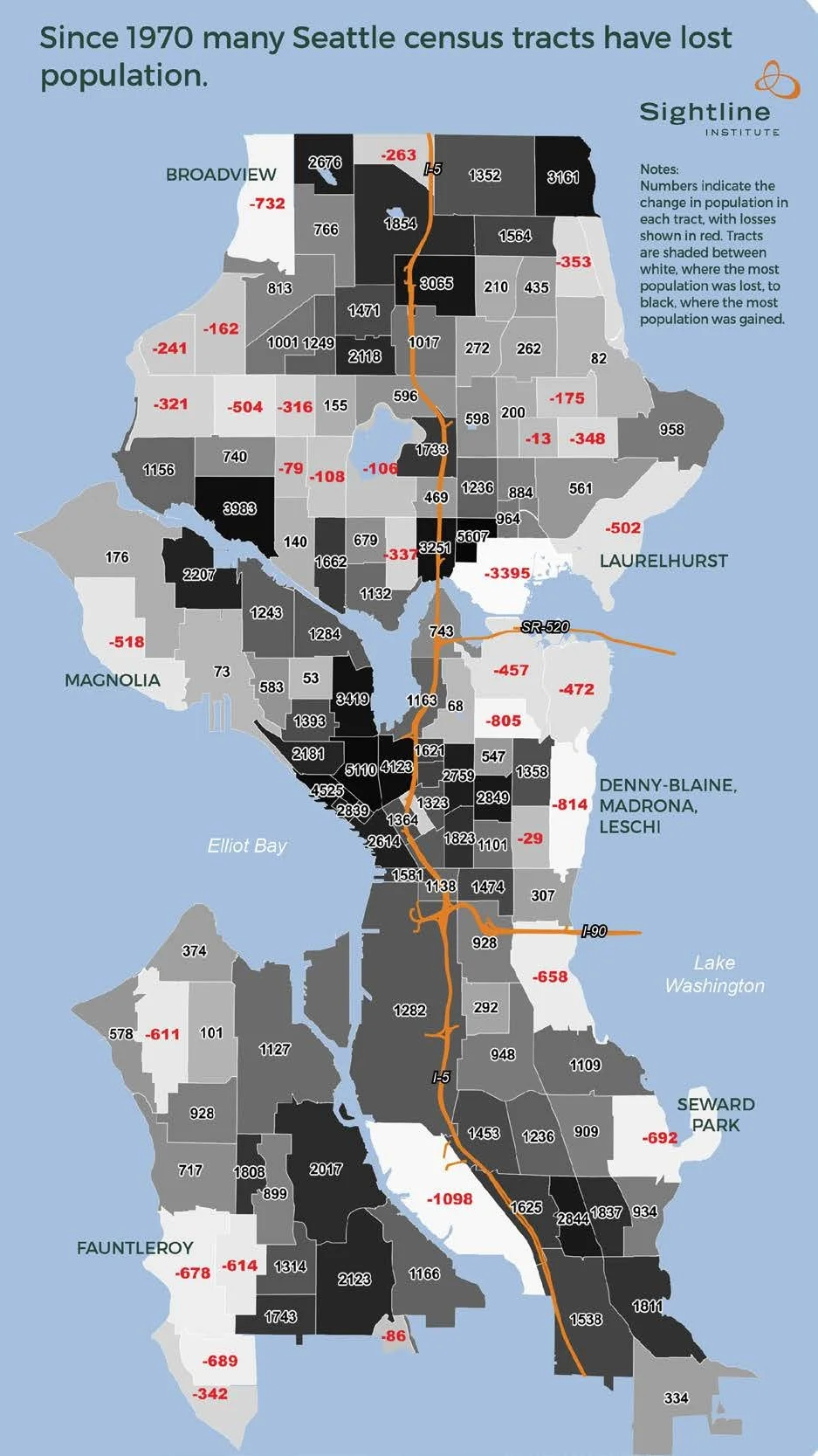
Figure #44. Bertolet, Dan. Some Neighborhoods Losing Population, Despite the Boom. Sightline Institute. 2017. https://www.sightline.org/2017/05/04/some-neighborhoods-losing-population-despite-the-boom/The last major comprehensive plan update occurred in 2015 and was titled “Seattle 2035” (City of Seattle Comprehensive Plan, 2015). As the previous Comprehensive Plan of 1994 centered much of its strategies on sustainability and environmental design, the 2015 plan focused on race and social justice as a primary focus (Seattle Municipal Archives, 2023). Despite this, the urban village strategy remained. “Since 2012, more than 80 percent of new housing has gone to these compact, mixed-use areas near transit and services. That also means that, despite rapid population growth in recent years, many areas outside urban villages have fewer residents today than they did decades ago” (City of Seattle Comprehensive Plan, 2015). See, for example, Figure #44, which notes the population loss in neighborhoods noted in white, and population gain in neighborhoods noted in dark gray and black. The neighborhoods which have seen the most amount of population loss are those without affordable and diverse housing options due to their zoning designation. In Figure 45, we see an overlay in red which represents multi-family zones as of 2017. It’s seemingly obvious that neighborhoods with denser zoning allowances would see an increase in population, but policy that has historically protected the detached single-family typology has created an imbalance. Additionally, due to the small amount of area allocated for population growth in the city, when development occurs, it risks existing affordable housing options in older buildings. The justification for isolating density into small areas in the city typically has to do with available resources and infrastructure. However, a new study conducted by Nat Henry analyzed Seattle’s walkability in terms of proximity to bus stops, parks, and restaurants. He found that nearly all of Seattle can access these elements within a 5-minute walk, arguing that Seattle already has the infrastructure to be a 15-minute city (Henry, 2023).
2015: Comprehensive Plan, Note Urban Centers + Urban Villages
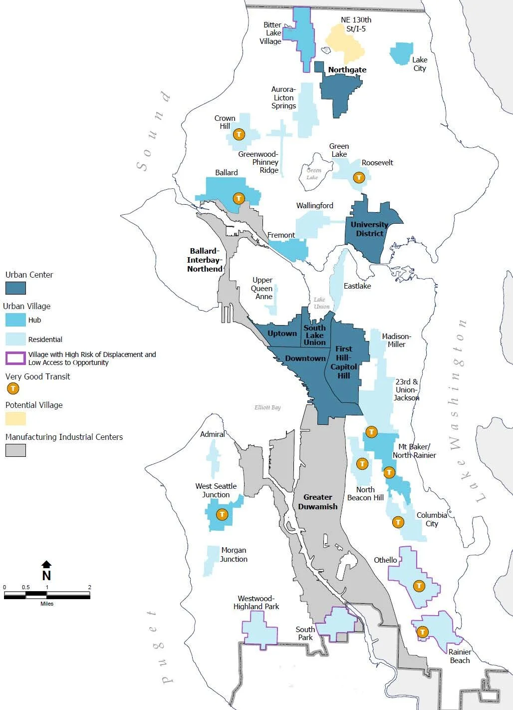
Figure #46. “The City of Seattle Comprehensive Plan: Seattle 2035.” (Seattle Office of Planning and Community Development, 2015).ComprehensivePlanCouncilAdopted2021.pdf2017: Population Loss Less in Multifamily
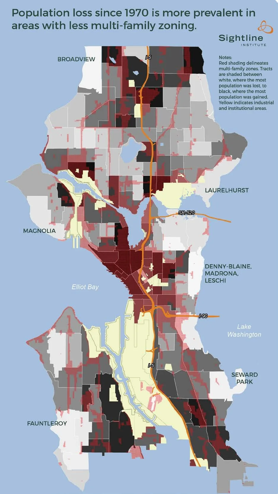
Figure #45.Bertolet, Dan. Some Neighborhoods Losing Population, Despite the Boom. Sightline Institute. 2017. https://www.sightline.org/2017/05/04/some-neighborhoods-losing-population-despite-the-boom/2023: Walking Time to Bus Stops accessing Downtown Seattle
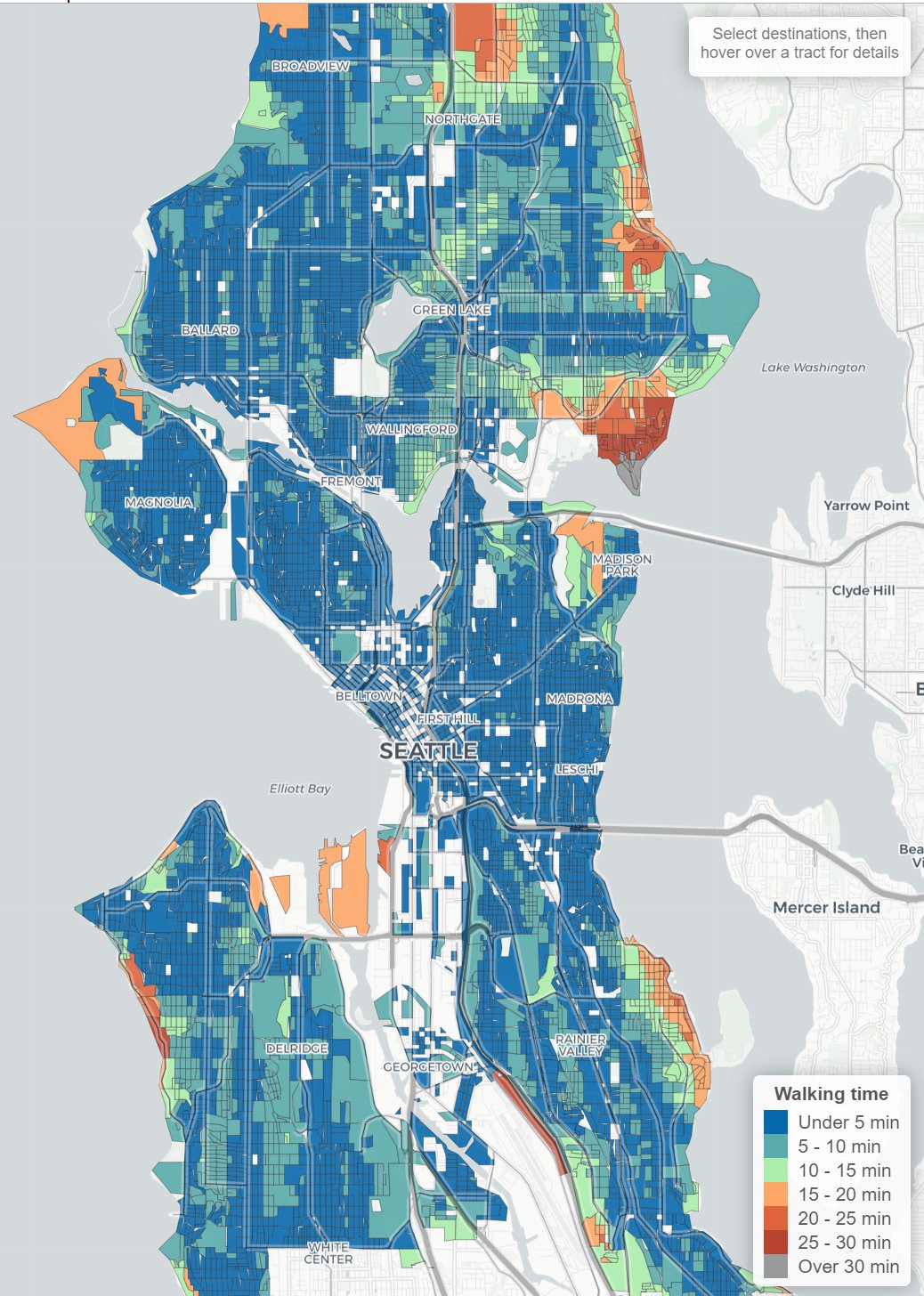
Figure #47. Henry, Nat. “Is Seattle a 15-Minute City? It Depends on Where You Want to Walk.” 2023. https://nathenry.com/writing/2023-02-07-seattle-walkability.html.This is demonstrated in Figures #47, #48, and #49. In comparison, Figure #46 shows the current Comprehensive Plan’s urban village strategy isolated areas of growth and density in small pockets of the city, with the justification that these areas “can better accept growth” (City of Seattle Comprehensive Plan, 2015). According to Henry’s study, over 99% of Seattle’s residents have walking access to parks, and 97% have walking access to bus stops which access the city’s downtown core (Henry, 2023). It is important to note that in relation to transit, this study only highlights the accessibility to transit stops, and does not address travel time or service frequency. This highlights that these systems are deeply reliant on integration between one another, and investment in improving public transit and other infrastructure is integral to arguing for successful cities. It’s clear that the city of Seattle is on its way to accommodate growth in more areas of the city than those outlined by previous zoning and comprehensive plans. “Blocks with 15-minute walking access to basic amenities extend far beyond the boundaries of the urban villages targeted in Seattle’s previous Comprehensive Plan. These [neighborhoods] of walkability could be the starting point for targeting more inclusive growth across the city” (Henry, 2023).
2023: Walking Time to Parks
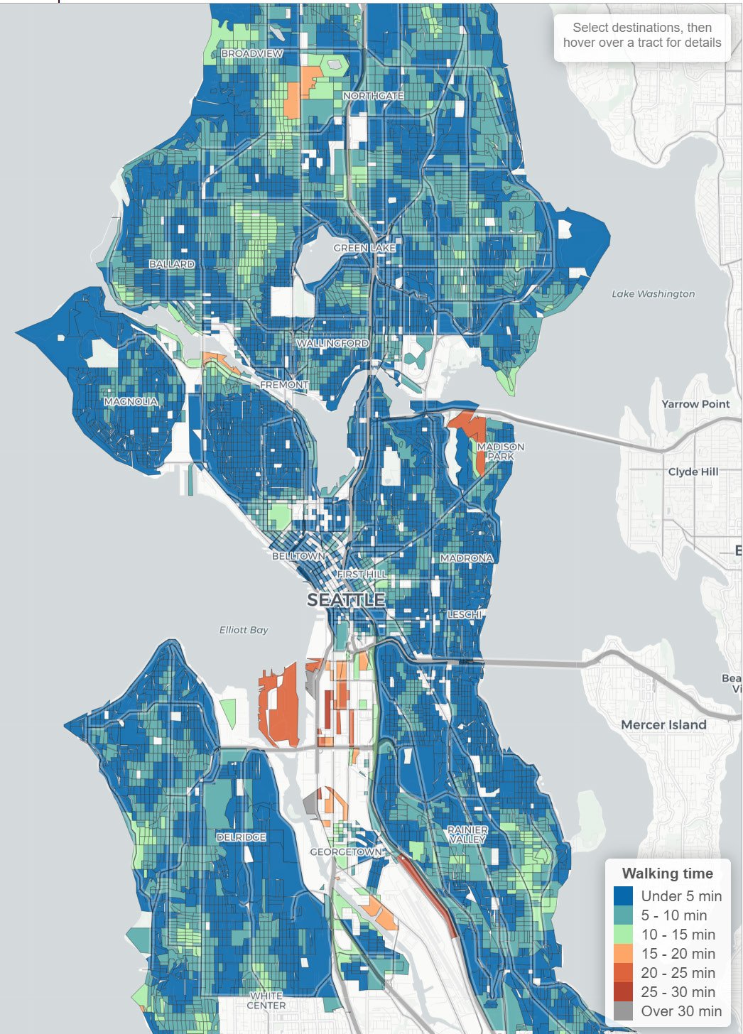
Figure #48. Henry, Nat. “Is Seattle a 15-Minute City? It Depends on Where You Want to Walk.” 2023. https://nathenry.com/writing/2023-02-07-seattle-walkability.html.2023: Walking Time to Restaurants
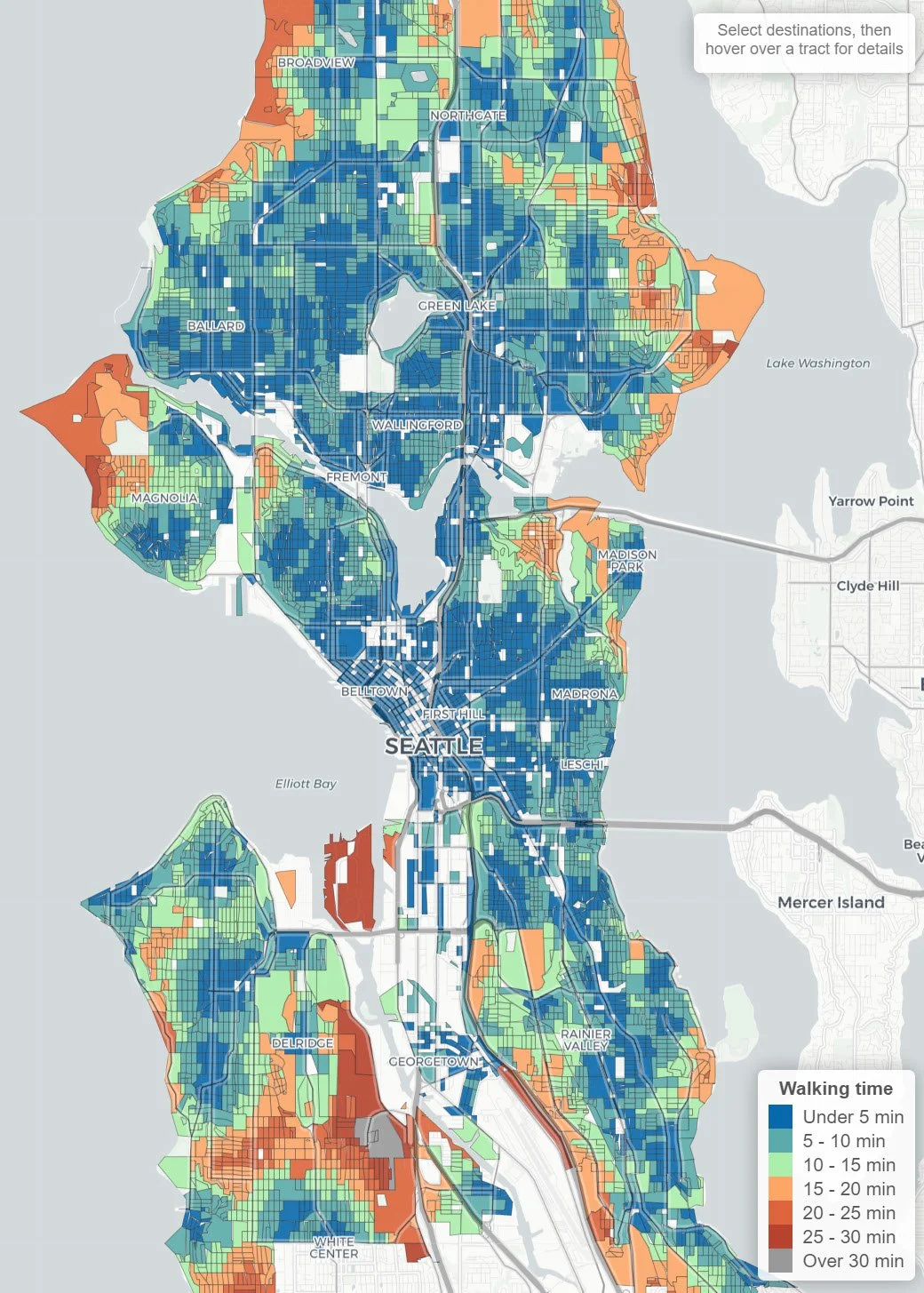
Figure #49. Henry, Nat. “Is Seattle a 15-Minute City? It Depends on Where You Want to Walk.” 2023. https://nathenry.com/writing/2023-02-07-seattle-walkability.html.In terms of zoning, classifications have evolved. There are more zoning designations than previous codes, with 10 residential categories, 3 neighborhood commercial categories, various mixed, commercial, downtown classifications, and 4 industrial categories (Table #1). Out of the current residential zoning designations, NR-1 -2 and -3 (Neighborhood Residential, previously single-family residential) allow for only 1 single-family dwelling unit per lot, and two accessory dwelling units (ADUs). Between the three NR designations, they vary in the minimum lot size required for each dwelling unit. These zones also have FAR, lot coverage, height limit, setbacks, and parking requirements (Seattle’s Neighborhood Residential Zones, 2019). RSL (Neighborhood Residential Small Lot) are zones that allow for the development of one or more dwelling units in small-scale structures in urban villages. Density restrictions in this zone is based on 1 dwelling unit per 2,000 sf, and looks towards attached housing, cottage style housing, and stacked flats as housing typologies. The rest of the residential zones including residential multifamily and residential commercial zones allow for more density but are limited to only one-quarter of residential land (See Figure #50). Current zoning policies are limiting Seattle’s potential to address issues of equity and affordability. Currently, its restrictive zoning creates economic incentives to demolish smaller and relatively affordable units to build larger and more expensive structures leading to a lack of economic diversity. With increasing demand and growing pressures from parts of the community, it’s essential to re-examine historic and existing zoning policies to understand their flaws. Different levels of the government have been doing just this with both the 2024 Comprehensive Plan update, as well as the Middle Housing Bill (HB 1110) at the state level.
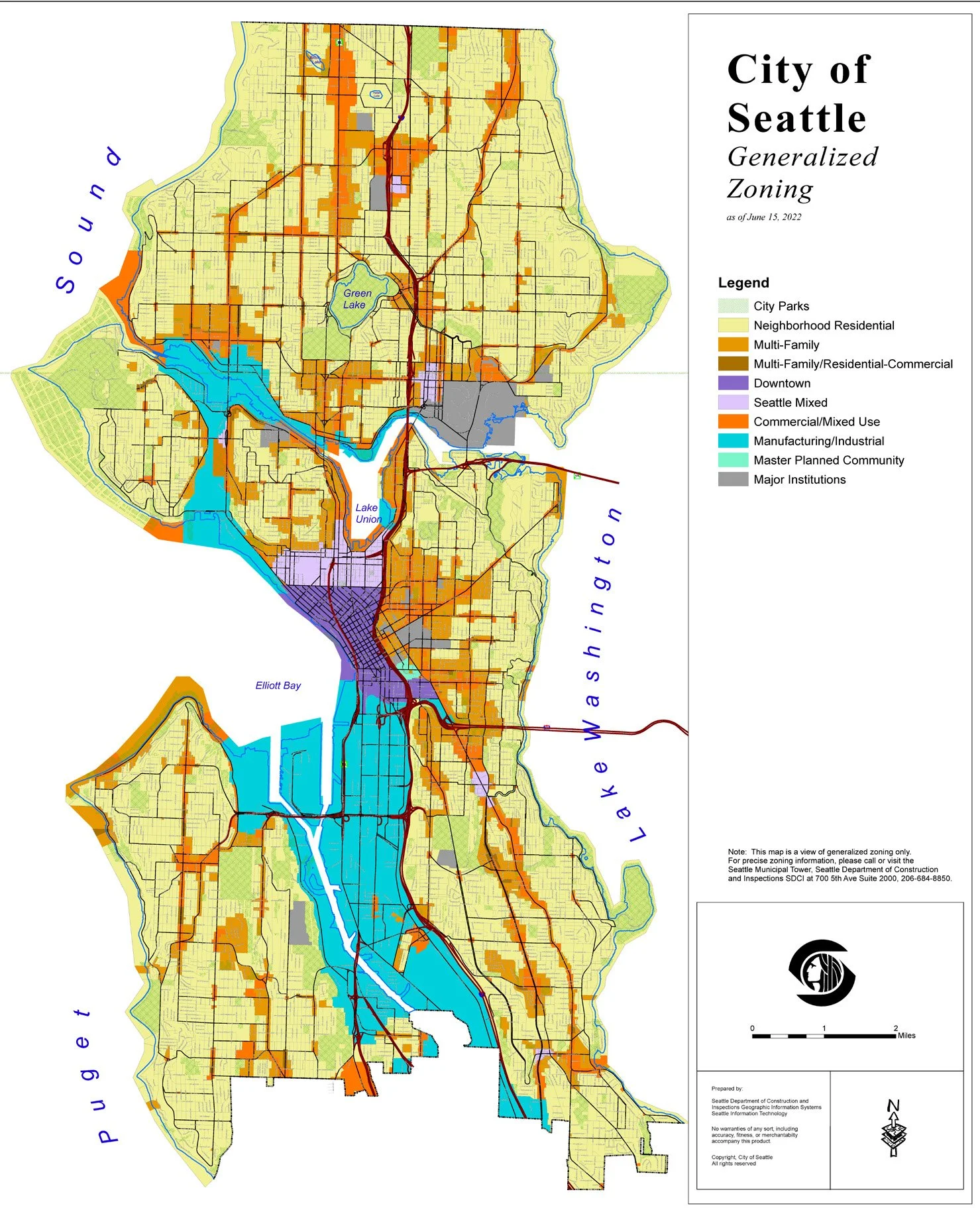
2022: City of Seattle Generalized Zoning Map
Figure #50. City of Seattle Generalized Zoning Map. 2022. City of Seattle. https://www.seattle.gov/dpd/cms/groups/pan/@pan/documents/web_informational/dpds022048.pdf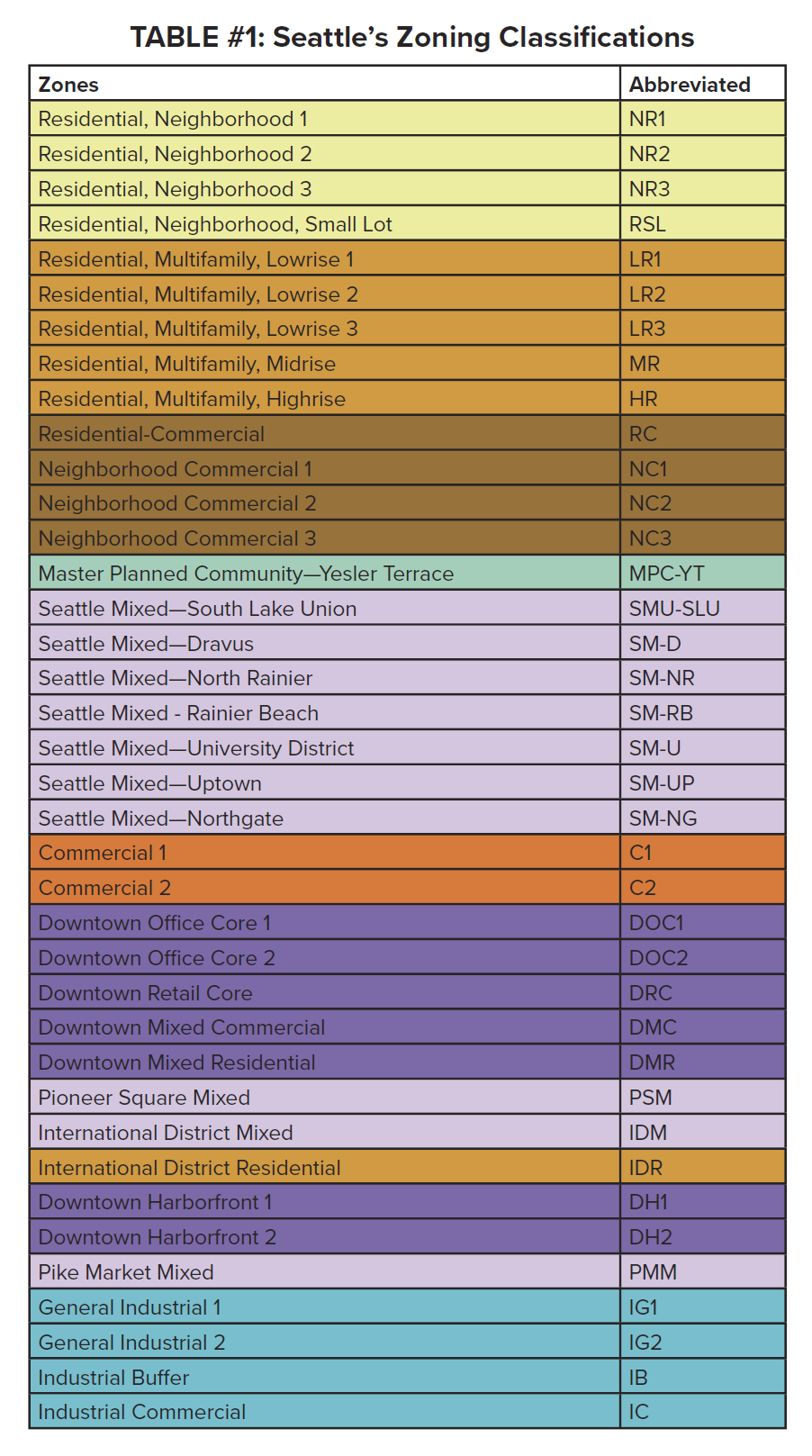
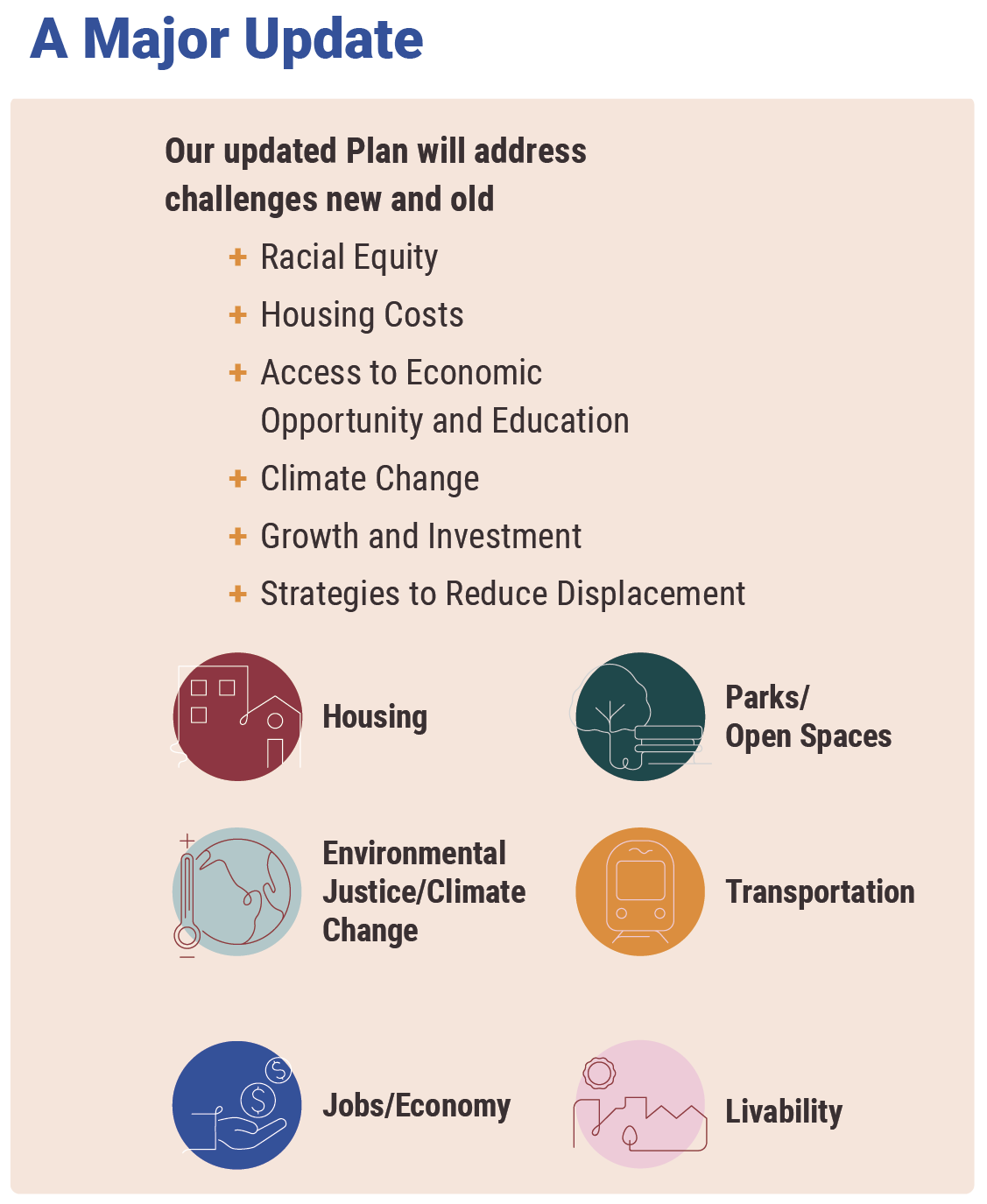
Figure #51. Office of Planning & Community Development. One Seattle Comprehensive Plan Nov 14 Poster. City of Seattle. 2023. https://www.seattle.gov/documents/Departments/OPCD/
SeattlePlan/OneSeattlePlanNov14PosterENGLISH.pdf
Looking Forward
2024 Comprehensive Plan Update
Looking forward, Seattle’s Office of Planning & Community Development (OPCD) is currently in the process of updating its comprehensive plan once more. The city has an opportunity to re-imagine what policy might look like if it finally embraced density in its urban neighborhoods. The new plan is titled the “One Seattle Plan,” and is scheduled to be completed in 2024. OPCD has conducted several public engagement sessions to gather community input since early 2022 (See Figure #52). Like previous comprehensive plans, it intends to guide the city on growth strategies, land use, transportation, housing, capital facilities, utilities, economic development, shorelines, container ports, environmental concerns, parks and open space, arts and culture, community well-being, and community involvement (Office of Planning & Community Development, 2022).
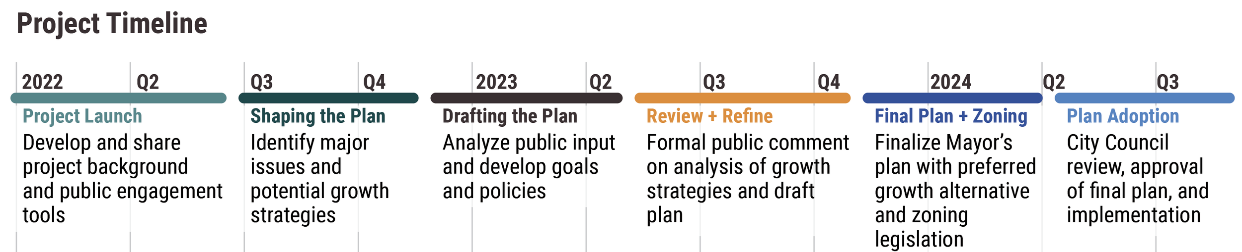
Figure #52. Office of Planning & Community Development. One Seattle Comprehensive Plan Nov 14 Poster. City of Seattle. 2023. https://www.seattle.gov/documents/Departments/OPCD/SeattlePlan/OneSeattlePlanNov14PosterENGLISH.pdfThe plan is driven by four core values: community, environmental stewardship, economic opportunity and security, and race and social equity (Office of Planning & Community Development, 2022). It hopes to address both new and old challenges relating to racial equity, housing costs, access to economic opportunities and education, climate change, growth and investment, and strategies to reduce investment (Office of Planning & Community Development, 2022). It’s also updating the urban village strategy, attempting to address issues of affordability and housing diversity. The city conducted a racial equity analysis and found “that the Urban Village Strategy perpetuates a historical pattern of exclusion and increases displacement pressures on communities of color,” and is expecting that various proposed growth alternatives will allow for more housing supply and choices across the city (Office of Planning & Community Development, 2021). Given this, the city has offered 5 potential growth models as alternatives to the urban village strategy and part of their Environmental Impact Statement (EIS) and will be studying their effects on the city. Those 5 alternatives include Alternative 1: No Action, Alternative 2: Focused, Alternative 3: Broad, Alternative 4: Corridors, and Alternative 5: Combined (See Figures #53 and #54) (Office of Planning & Community Development, 2022). Their plan is to choose a final growth strategy by 2024, likely being a “hybrid approach that draws from the strategies and locations in the alternatives” (Office of Planning & Community Development, 2022). Each alternative offers a different approach to growth locations, scale, and density. This has implications on both housing and jobs. Through community engagement outreach, OPCD has found that community members have increasingly supported the idea of increasing density everywhere (see Figure #55). Community members acknowledge that “historically marginalized communities should not bear all the expanded development and associated burden” which comes from the urban village strategy (Office of Planning & Community Development, 2022). Organizations like Share the Cities and Real Change have challenged the proposed alternatives, and expressed the need for a more radical approach, recognizing the need for innovative options. They’ve called this Alternative 6, posing the idea that Seattle must rezone “for denser housing throughout the city, not just in nodes or corridors” (Sethi, 2022). Alternative 6 also calls for investment in permanently affordable housing options, eliminating parking mandates for both business and residential developments, support for anti-displacement policy through community leadership, utilizing surplus urban land, expanding protected bike lanes and public transportation options, and supporting concepts of the 15-minute city (Real Change, 2022). In light of OPCD’s developments in the comprehensive plan update, Real Change has urged them to focus on allowing more housing outside of just urban villages, and increase density in neighborhoods where typically only single-family homes are available.
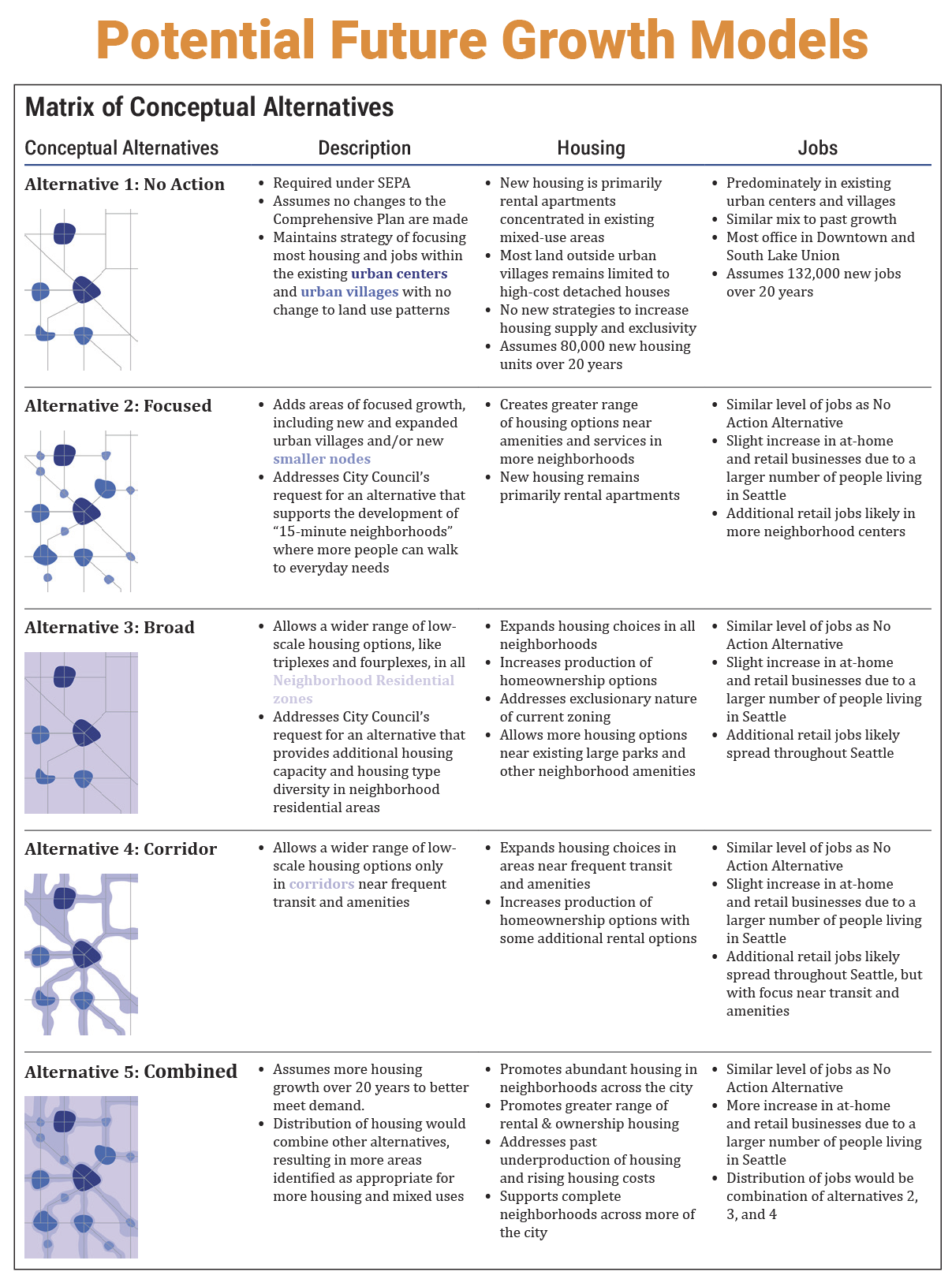
Figure #53. Office of Planning & Community Development. One Seattle Comprehensive
Plan Nov 14 Poster. City of Seattle. 2023. https://www.seattle.gov/documents/
Departments/OPCD/SeattlePlan/OneSeattlePlanNov14PosterENGLISH.pdf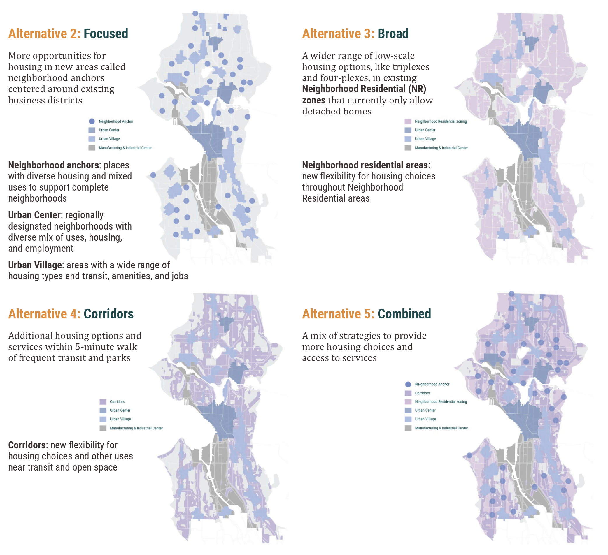
Figure #54. Office of Planning & Community Development. One Seattle Comprehensive Plan EIS Scoping Fact Sheet. City of Seattle. 2023. https://www.seattle.gov/documents/Departments/OPCD/SeattlePlan/OneSeattlePlanEISScopingFactSheet.pdfHB 1110 Middle Housing Bill
Washington has been trying to address these issues at the State level as well. The state of Washington recently passed the Middle Housing Bill HB 1110 - 2023-24 which aims to increase affordable and diverse housing options by allowing the development of missing-middle housing city-wide. This includes duplexes, triplexes, quadplexes, townhomes, and small apartment buildings, in all residential areas—including those currently zoned for detached single-family homes. The bill has undergone various changes due to pressures from state legislators and other local interests. Currently, for cities with at least 25,000 residents but less than 75,000 residents, the bill proposes setting a minimum of two homes per lot on every residentially zoned lot, and four homes per lot on every residentially zoned lot if one home is affordable or the property is within a half-mile of a major transit stop or community amenity (H.B. 1110, 2023). For cities with at least 75,000 residents or any city in a contiguous urban growth area with a city above 200,000 residents, a minimum of four homes per lot on all residentially zoned lots, and six homes per lot on all residentially zoned lots if two homes are affordable or if the property is within a half-mile of a major transit stop or community amenities (H.B. 1110, 2023). Additionally, this bill addresses off-street parking requirements, a very contested issue within growth management proposals. Starting with a more radical approach, this section has de-radicalized from its original suggestion that for middle housing, off-street parking shall not be required within a half-mile of a major transit stop, and that no more than one off-street parking spot shall be required per lot on lots smaller than 6,000 sf, and no more than two off-street parking spaces shall be required per lot on lots greater than 6,000 sf (H.B. 1110, 2023). The bill has been amended, and now notes that the original suggestion only applies if a professional study with empirical evidence that demonstrates that less off-street parking in a defined area would make on-street parking unfeasible or significantly unsafe for middle housing (H.B. 1110, 2023). As a whole, this bill has re-legalized denser housing options amongst larger cities across the state. According to an analysis conducted by the Puget Sound Regional Council, the bill will create approximately 200,000 additional dwelling units categorized as middle housing within the next 20 years (Puget Sound Regional Council HB 1110 Analysis, 2023). This bill is setting a statewide baseline for housing density policies, requiring cities to comply. Cities, such as Seattle, could then expand upon this baseline, but could not enforce or enact zoning policies less dense than the bill outlines. The will take effect six months after the 2024 major comprehensive plan update.
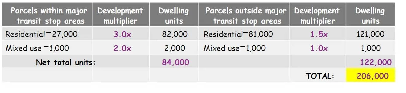
Development Estimate of Middle Housing Production, Puget Sound Regional Council HB 1110 Analysis
Figure #56. Puget Sound Regional Council. HB 1110 Analysis. 2023. https://www.scribd.com/document/627765265/Puget-Sound-Regional-Council-HB-1110-Analysis-February-2023#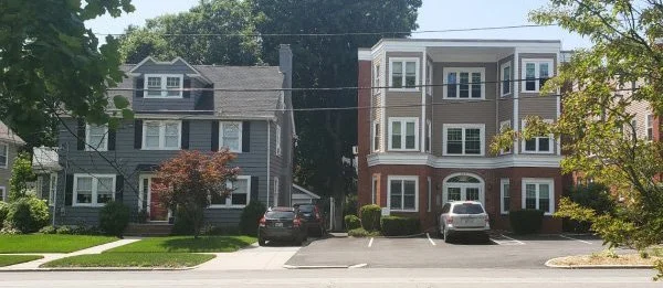
Figure #58 Stanton, Melissa. A single-family home and small apartment building are neighbors along urban greenway in Providence, Rhode Island. AARP. 2020. https://www.aarp.org/livable-communities/housing/info-2020/barriers-to-missing-middle-housing.html.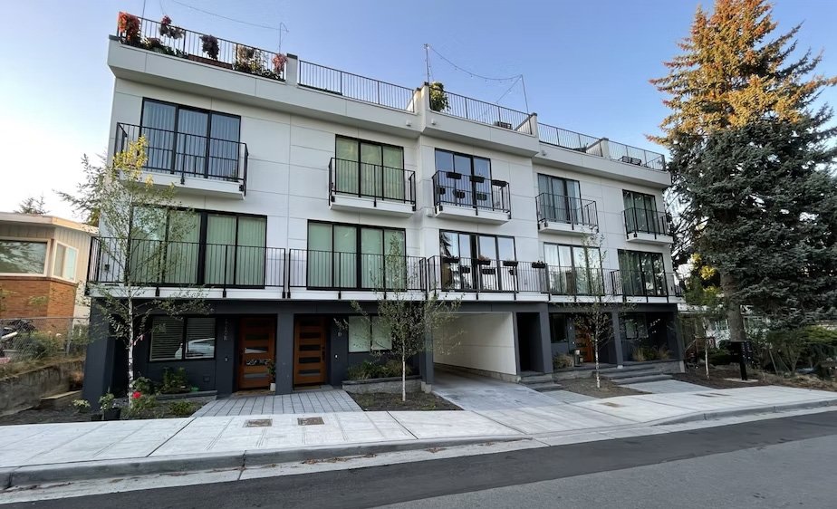
Figure #57 McNichols, Joshua. Seattle has some middle housing, but it’s not allowed in most parts of the city. KUOW. 2023. https://www.kuow.org/stories/middle-housing-bill-passes-major-milestone-in-OlympiaLimitations
As cities continue to densify, more people have chosen to live in urban areas versus rural ones—and “for the first time in history, more humans live in cities than outside” them (Sisolak, 2011). Issues of urban density are both a racial equity issue, as well as an environmental one. Initially, the purpose of zoning aimed to separate incompatible uses and to preserve and protect property values as a method to protect certain neighborhoods. Zoning evolved into a tool to discriminate both economically and racially (Schindler, 2015). There are disagreements around the question of whether Seattle’s zoning and planning history was intended to be racially discriminatory. Regardless of intent, it’s clear that Seattle’s land-use policies have produced issues of equity and both racial and economic discrimination. Access to homeownership and in turn generational wealth has affected marginalized communities, particularly communities of color. With policies that did not address issues of housing access, and instead, downzoned many neighborhoods and exacerbated housing affordability, Seattle’s zoning laws have been highly criticized for perpetuating economic and racial segregation. While single-family zoning only covered roughly one-third of Seattle’s 1923 landscape, today they take up about 70 percent of the city’s residentially zoned land (Seattle Ordinance No. 45382, 1923). The legacy of inequitable land-use policy has recently been acknowledged, as the city notes they’re “now looking at how [the urban village strategy] has benefited some people and bordered others in inequitable ways and [they’re now] exploring new ways to grow that achieve more equitable and affordable housing and neighborhood choice for all” (Centering Racial Equity in the One Seattle Comprehensive Plan, 2022). Currently, these issues are being addressed at both the city-scale through the “One Seattle” Comprehensive Plan Update of 2024, as well as at the state level through the Middle Housing Bill HB 1110. Both approaches have the opportunity to encourage the development of missing-middle housing to increase density as a means to increase housing affordability. However, these proposed changes face limitations, particularly in the realm of private covenants that may be enforced to resist change. Private covenants, as mentioned previously, are deed restrictions that are tied to the land. Some private covenants in largely white affluent neighborhoods in Seattle contain language which restricts density. For example, the Broadmoor neighborhood of Seattle still contains a restrictive covenant that states its properties “will not use or permit such dwelling house to be used except as the home of only one family” (See Figure #59) (The Seattle Civil Rights & Labor History Project, 2021). Private land use controls may pose a threat to policies which increase density because they may be used as legal justification to maintain the status quo. SHB 1110, begins to address this issue in Sections 13 and 14, which prohibits new private covenants that do not allow middle housing densities (H.B. 1110, 2023). Additionally, some legislators have discussed adding an amendment that would retroactively invalidate any private covenant that prohibits middle housing, but there are probably not enough votes to adopt that amendment (H.B. 1110, 2023). It is unclear whether private covenants are a significant barrier to both the missing middle bill, as well as Seattle’s developing comprehensive update. If they prove to be a major barrier, passing a state law invalidating them may be the safest solution.
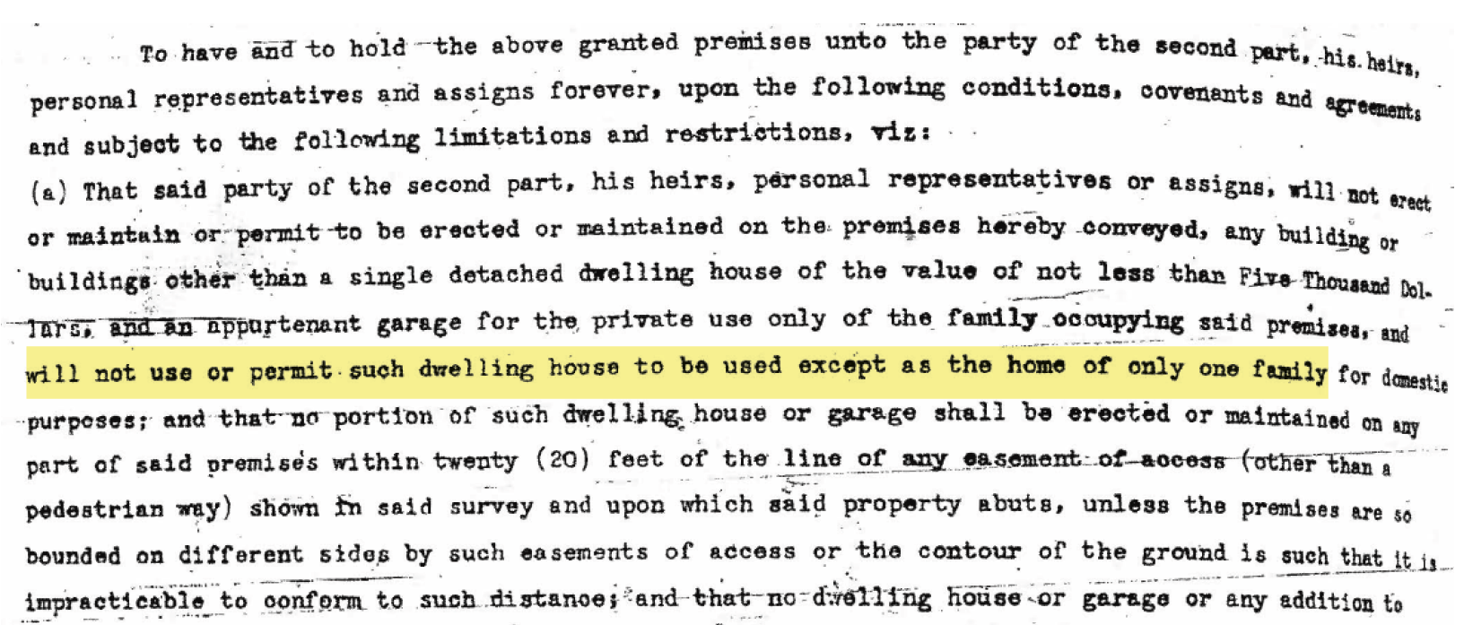
Figure #59 Density restrictions written in the subdivision plat or accompanying restrictive covenant of the Broadmoor neighborhood of Seattle. Source: The Seattle Civil Rights & Labor History Project. The University of Washington. 2021. http://depts.washington.edu/civilr/covenants/Broadmoor(5).PDFRegardless of the potential limitations in current proposals that increase density in Seattle, more than half of the city’s residents support rezones which would place multi-family homes in historically single-family neighborhoods (Groover, 2017). Additionally, other arguments against increasing density include the need to protect a neighborhood’s aesthetic character. However, no action does not prevent a neighborhood’s character from erosion, as new construction—even if it maintains single-family densities—will disrupt form, size, and aesthetic qualities. The need for increased density is apparent, and zoning has a complex and nuanced history that reflects the social and political climate of the city over the past century. Despite an increased understanding of land-use inequities, and some recent proposals towards more equitable and inclusive zoning policies, there is still much work that needs to be done to address historic land-use discrimination and to promote more affordable and diverse housing options throughout the city. Seattle must aim to correct policies that perpetuate segregation. “History has shown that passively waiting for gradual change towards integration is not—and never will be—enough. De jure segregation can only be rectified through de jure integration, and a great deal remains to be done” (Kim, 2021).